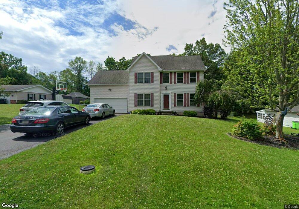
129 Forest Rd Mountain Top, PA 18707
Estimated Value: $301,000 - $436,000
4
Beds
3
Baths
2,388
Sq Ft
$163/Sq Ft
Est. Value
About This Home
This home is located at 129 Forest Rd, Mountain Top, PA 18707 and is currently estimated at $388,098, approximately $162 per square foot. 129 Forest Rd is a home located in Luzerne County with nearby schools including Crestwood Secondary Campus (Crestwood High School) and St Jude School.
Ownership History
Date
Name
Owned For
Owner Type
Purchase Details
Closed on
Oct 31, 2022
Sold by
Bhatti Vipander and Bhatti Sandhya Dahal
Bought by
Bhatti Vipander and Bhatti Sandhya Dahal
Current Estimated Value
Purchase Details
Closed on
Feb 21, 2017
Sold by
Smith David L and Smith Erica M
Bought by
Bhatti Vipander
Home Financials for this Owner
Home Financials are based on the most recent Mortgage that was taken out on this home.
Original Mortgage
$274,928
Interest Rate
4.4%
Mortgage Type
FHA
Purchase Details
Closed on
Apr 15, 2010
Sold by
Bertram David and Mirra Michael
Bought by
Smith David L and Smith Erica M
Home Financials for this Owner
Home Financials are based on the most recent Mortgage that was taken out on this home.
Original Mortgage
$274,928
Interest Rate
5.5%
Mortgage Type
FHA
Purchase Details
Closed on
Jan 24, 2006
Sold by
Raineri Kenneth and Raineri Andrea
Bought by
Bertram David and Mirra Michael
Create a Home Valuation Report for This Property
The Home Valuation Report is an in-depth analysis detailing your home's value as well as a comparison with similar homes in the area
Home Values in the Area
Average Home Value in this Area
Purchase History
| Date | Buyer | Sale Price | Title Company |
|---|---|---|---|
| Bhatti Vipander | -- | -- | |
| Bhatti Vipander | -- | None Listed On Document | |
| Bhatti Vipander | $280,000 | None Available | |
| Smith David L | $280,000 | None Available | |
| Bertram David | $51,500 | None Available |
Source: Public Records
Mortgage History
| Date | Status | Borrower | Loan Amount |
|---|---|---|---|
| Previous Owner | Bhatti Vipander | $274,928 | |
| Previous Owner | Smith David L | $274,928 |
Source: Public Records
Tax History Compared to Growth
Tax History
| Year | Tax Paid | Tax Assessment Tax Assessment Total Assessment is a certain percentage of the fair market value that is determined by local assessors to be the total taxable value of land and additions on the property. | Land | Improvement |
|---|---|---|---|---|
| 2025 | $6,091 | $292,200 | $32,500 | $259,700 |
| 2024 | $5,989 | $292,200 | $32,500 | $259,700 |
| 2023 | $5,801 | $292,200 | $32,500 | $259,700 |
| 2022 | $5,747 | $292,200 | $32,500 | $259,700 |
| 2021 | $5,625 | $292,200 | $32,500 | $259,700 |
| 2020 | $5,281 | $292,200 | $32,500 | $259,700 |
| 2019 | $5,030 | $292,200 | $32,500 | $259,700 |
| 2018 | $4,872 | $292,200 | $32,500 | $259,700 |
| 2017 | $4,872 | $292,200 | $32,500 | $259,700 |
| 2016 | -- | $292,200 | $32,500 | $259,700 |
| 2015 | $3,847 | $292,200 | $32,500 | $259,700 |
| 2014 | $3,847 | $292,200 | $32,500 | $259,700 |
Source: Public Records
Map
Nearby Homes
- 314 Hemlock Terrace
- 45 Fieldstone Way
- 8 Hazlenut Dr
- 11 Valley Ln
- 289 Hemlock Terrace
- 64 Valley View Dr
- 1 Taylor Cir
- 5 Taylor Cir
- 2 Taylor Cir
- 11 Oaklawn Ave
- 263 S Mountain Blvd
- 129 Timberwood Dr
- 3 Oak Dr
- 0 Sterling St
- 19 Regina Dr
- 38 Terrace Dr
- 0 Aleksander Blvd
- 14 Basswood Dr
- 1012 Woodberry Dr
- 116 Jennifer's Way