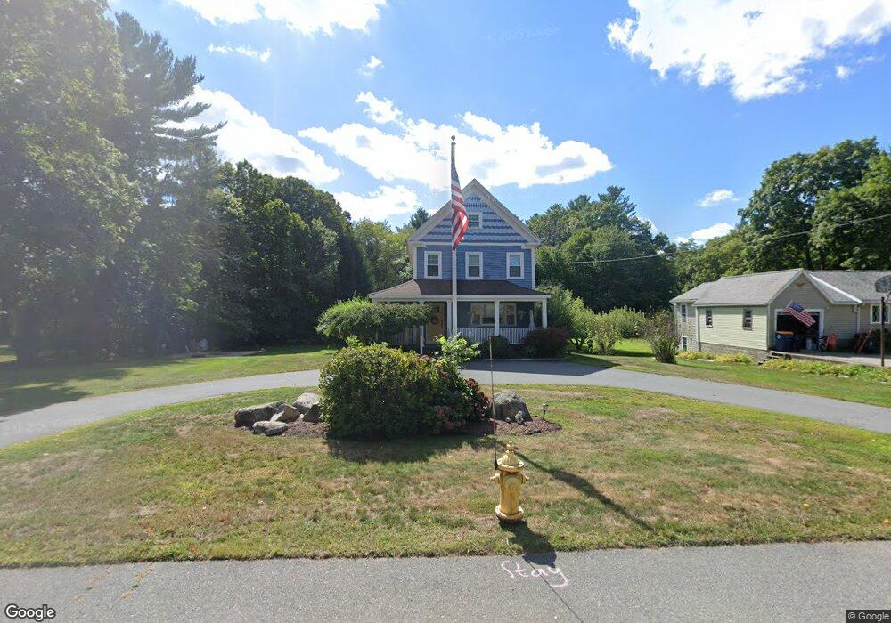
129 High St Norwell, MA 02061
Estimated Value: $686,000 - $856,836
4
Beds
3
Baths
2,658
Sq Ft
$298/Sq Ft
Est. Value
About This Home
This home is located at 129 High St, Norwell, MA 02061 and is currently estimated at $791,209, approximately $297 per square foot. 129 High St is a home located in Plymouth County with nearby schools including Grace Farrar Cole Elementary School, Norwell Middle School, and Norwell High School.
Ownership History
Date
Name
Owned For
Owner Type
Purchase Details
Closed on
Nov 20, 2006
Sold by
Zieper Matthew and Zieper Debra Wein
Bought by
Decouto Anthony and Decouto Kelly A
Current Estimated Value
Home Financials for this Owner
Home Financials are based on the most recent Mortgage that was taken out on this home.
Original Mortgage
$355,500
Interest Rate
6.33%
Mortgage Type
Purchase Money Mortgage
Purchase Details
Closed on
Jul 16, 2001
Sold by
Manwill Aaron W and Manwill Ann S
Bought by
Zieper Matthew and Zieper Debra W
Purchase Details
Closed on
Aug 23, 1999
Sold by
Putnam Gloria
Bought by
Manwill Aaron and Manwill Ann S
Create a Home Valuation Report for This Property
The Home Valuation Report is an in-depth analysis detailing your home's value as well as a comparison with similar homes in the area
Home Values in the Area
Average Home Value in this Area
Purchase History
| Date | Buyer | Sale Price | Title Company |
|---|---|---|---|
| Decouto Anthony | $444,375 | -- | |
| Decouto Anthony | $444,375 | -- | |
| Zieper Matthew | $363,000 | -- | |
| Zieper Matthew | $363,000 | -- | |
| Manwill Aaron | $175,000 | -- | |
| Manwill Aaron | $175,000 | -- |
Source: Public Records
Mortgage History
| Date | Status | Borrower | Loan Amount |
|---|---|---|---|
| Open | Manwill Aaron | $400,800 | |
| Closed | Manwill Aaron | $355,500 |
Source: Public Records
Tax History
| Year | Tax Paid | Tax Assessment Tax Assessment Total Assessment is a certain percentage of the fair market value that is determined by local assessors to be the total taxable value of land and additions on the property. | Land | Improvement |
|---|---|---|---|---|
| 2025 | $9,257 | $708,300 | $355,400 | $352,900 |
| 2024 | $9,104 | $676,400 | $354,000 | $322,400 |
| 2023 | $8,856 | $579,200 | $315,200 | $264,000 |
| 2022 | $8,528 | $513,100 | $249,100 | $264,000 |
| 2021 | $8,421 | $497,100 | $262,200 | $234,900 |
| 2020 | $7,859 | $472,600 | $262,200 | $210,400 |
| 2019 | $7,287 | $444,300 | $256,900 | $187,400 |
| 2018 | $6,899 | $422,200 | $262,200 | $160,000 |
| 2017 | $6,945 | $422,200 | $262,200 | $160,000 |
| 2016 | $6,734 | $408,100 | $262,200 | $145,900 |
| 2015 | $6,625 | $401,500 | $262,200 | $139,300 |
| 2014 | $6,306 | $385,200 | $247,700 | $137,500 |
Source: Public Records
Map
Nearby Homes
- 214 Washington St Unit 24
- 214 Washington St Unit 28
- 8 Blueberry Ct
- 18 Colby St
- 303 Pond St
- 18 Winterberry Ln
- 55 Turner Rd
- 49 Washington Park Dr
- 17 Pine Haven Cir
- 738 Whiting St
- 108 Deerfield Ln
- 100 Whiting St
- 46 Brookwood Rd
- 535 Webster St
- 26 Hobart Ln Unit 26,C
- 251 Prospect St
- 225 Prospect St
- 183 Gardner St
- 4 Kerri Ln
- 1 Kerri Ln
Your Personal Tour Guide
Ask me questions while you tour the home.