
Seller's Agent in 2026
Sara Marie Brenner
Axen Realty LLC
(740) 816-9339
68 Total Sales


Estimated Value: $288,259 - $327,000
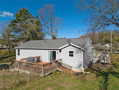
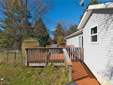
Welcome to this stunning 3-bedroom 2.5-bathroom home built in 2019, offering a perfect blend of modern design and thoughtful features throughout. Step inside to find a spacious open-concept floor plan with sleek Corian counter-tops and wood-surfaced, quiet-close cabinets in the kitchen. A standout feature is the Lazy Susan cabinet, providing easy access to your kitchen essentials. The large kitchen island serves as both a functional prep area and a gathering space. The master suite boasts an en-suite bathroom with an extra storage closet for added convenience. The two additional bedrooms are decently sized and share a beautifully designed full bathroom. Step outside to the back porch, perfect for enjoying your morning coffee or evening relaxation. The basement is a true gem- featuring a bar area and a half bath, plus plumbing already in place for a potential shower addition, making it a versatile space for any need. Whether it's a game room, home theater, or additional living area, the basement offers endless possibilities. This meticulously maintained home is move-in ready and ready to welcome its next owners. Seller is related to Agent.
Last Agent to Sell the Property
Axen Realty LLC Brokerage Email: sara@saramariebrenner.com, 740-816-9339 License #2019004969 Listed on: 11/07/2025
Co-Listed By
LPT Realty Brokerage Email: sara@saramariebrenner.com, 740-816-9339 License #2022004068
We collect this data history from publicly available records. To have your information removed, we recommend requesting removal directly through your county’s website.
| Date | Buyer | Sale Price | Title Company |
|---|---|---|---|
| Wilhelm Deanna Gail | -- | None Listed On Document | |
| Hart Christopher | $80,000 | None Available | |
| Hart Marlana | -- | -- | |
| Lucas Angela M | -- | -- | |
| Lucas Angela M | -- | -- | |
| Lucas Angela M | $27,700 | -- | |
| Lucas Angela M | $21,500 | -- | |
| Lucas Angela M | $19,000 | -- |
We collect this data history from publicly available records. To have your information removed, we recommend requesting removal directly through your county’s website.
| Date | Status | Borrower | Loan Amount |
|---|---|---|---|
| Previous Owner | Lucas Angela M | $20,000 |
| Date | Event | Price | List to Sale | Price per Sq Ft |
|---|---|---|---|---|
| 01/07/2026 01/07/26 | Sold | $310,000 | +3.3% | $224 / Sq Ft |
| 11/07/2025 11/07/25 | For Sale | $300,000 | -- | $216 / Sq Ft |
| Year | Tax Paid | Tax Assessment Tax Assessment Total Assessment is a certain percentage of the fair market value that is determined by local assessors to be the total taxable value of land and additions on the property. | Land | Improvement |
|---|---|---|---|---|
| 2025 | $2,086 | $67,900 | $6,470 | $61,430 |
| 2024 | $1,786 | $56,580 | $5,390 | $51,190 |
| 2023 | $1,619 | $56,580 | $5,390 | $51,190 |
| 2022 | $1,468 | $51,530 | $5,390 | $46,140 |
| 2021 | $1,432 | $49,770 | $4,790 | $44,980 |
| 2020 | $1,433 | $49,770 | $4,790 | $44,980 |
| 2019 | $417 | $14,480 | $4,790 | $9,690 |
| 2018 | $445 | $14,880 | $5,650 | $9,230 |
| 2017 | $446 | $14,880 | $5,650 | $9,230 |
| 2016 | $453 | $14,880 | $5,650 | $9,230 |
| 2015 | $412 | $12,800 | $4,540 | $8,260 |
| 2014 | $412 | $12,800 | $4,540 | $8,260 |
| 2013 | $430 | $12,420 | $4,400 | $8,020 |
Seller's Agent in 2026
Sara Marie Brenner
Axen Realty LLC
(740) 816-9339
68 Total Sales
Seller Co-Listing Agent in 2026
Sasha Keevert
LPT Realty
(740) 213-6139
8 Total Sales
Buyer's Agent in 2026
Mary West
McCarthy Real Estate, Inc.
(740) 374-9297
68 Total Sales
Source: MLS Now
MLS Number: 5161470
APN: 05-160100.1000
Disclaimer: Certain information contained herein is derived from information provided by parties other than Homes.com. All information provided is deemed reliable, but is not guaranteed to be accurate and should be independently verified.
![]() IDX information is provided exclusively for personal, non-commercial use, and may not be used for any purpose other than to identify prospective properties consumers may be interested in purchasing. Information is deemed reliable but not guaranteed.
IDX information is provided exclusively for personal, non-commercial use, and may not be used for any purpose other than to identify prospective properties consumers may be interested in purchasing. Information is deemed reliable but not guaranteed.
Ask me questions while you tour the home.