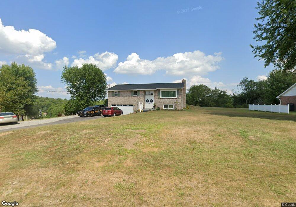
129 Marilyn Ln New Cumberland, WV 26047
Estimated Value: $154,000 - $276,000
3
Beds
2
Baths
1,225
Sq Ft
$175/Sq Ft
Est. Value
About This Home
This home is located at 129 Marilyn Ln, New Cumberland, WV 26047 and is currently estimated at $214,787, approximately $175 per square foot. 129 Marilyn Ln is a home located in Hancock County with nearby schools including St. Paul School.
Ownership History
Date
Name
Owned For
Owner Type
Purchase Details
Closed on
Jun 25, 2024
Sold by
Bell Derek G
Bought by
Cole Robert W and Cole Jodi L
Current Estimated Value
Home Financials for this Owner
Home Financials are based on the most recent Mortgage that was taken out on this home.
Original Mortgage
$120,000
Outstanding Balance
$116,408
Interest Rate
7.02%
Mortgage Type
New Conventional
Estimated Equity
$98,379
Purchase Details
Closed on
Apr 25, 2023
Sold by
Bell Larry G and Bell Derek G
Bought by
Bell Larry G and Bell Derek G
Create a Home Valuation Report for This Property
The Home Valuation Report is an in-depth analysis detailing your home's value as well as a comparison with similar homes in the area
Home Values in the Area
Average Home Value in this Area
Purchase History
| Date | Buyer | Sale Price | Title Company |
|---|---|---|---|
| Cole Robert W | $150,000 | None Listed On Document | |
| Bell Larry G | -- | None Listed On Document |
Source: Public Records
Mortgage History
| Date | Status | Borrower | Loan Amount |
|---|---|---|---|
| Open | Cole Robert W | $120,000 |
Source: Public Records
Tax History Compared to Growth
Tax History
| Year | Tax Paid | Tax Assessment Tax Assessment Total Assessment is a certain percentage of the fair market value that is determined by local assessors to be the total taxable value of land and additions on the property. | Land | Improvement |
|---|---|---|---|---|
| 2024 | $1,069 | $80,940 | $21,960 | $58,980 |
| 2023 | $1,033 | $80,940 | $21,960 | $58,980 |
| 2022 | $1,050 | $80,940 | $21,960 | $58,980 |
| 2021 | $1,046 | $80,340 | $21,960 | $58,380 |
| 2020 | $960 | $74,040 | $18,060 | $55,980 |
| 2019 | $966 | $73,380 | $18,060 | $55,320 |
| 2018 | $949 | $71,760 | $18,060 | $53,700 |
| 2017 | $930 | $69,600 | $17,160 | $52,440 |
| 2016 | $929 | $69,600 | $17,160 | $52,440 |
| 2015 | $794 | $67,680 | $17,160 | $50,520 |
| 2014 | $794 | $64,320 | $16,260 | $48,060 |
Source: Public Records
Map
Nearby Homes
- 0 Ohio River Blvd Unit 5057024
- VL Eagle Mountain Estate
- 141 Cleveland Rd
- 0 Kings Creek Rd Unit 5153364
- 1 Riverside Dr
- 1384 Kings Creek Rd
- 843 Rainey Hill Rd
- TBD Alta St
- 128 Alta St
- 154 Alta St
- 0 Laura Ln Unit 5153409
- 0 Wylie Ridge Rd Unit 5134114
- 214 Basil Dr
- 118 Wall St
- 120 Wall St
- 1206 S River Ave
- 268 Kingsview Dr
- 0 Locust St
- 608 Logan Ave
- 620 Mara Ln
- 179 Marilyn Ln
- 136 Marilyn Ln
- 126 Marilyn Ln
- 73 Marilyn Ln
- 156 Marilyn Ln
- 404 Margaret Dr
- 52 Marilyn Ln
- 202 Marilyn Ln
- 912 Wylie Ridge Rd
- 934 Wylie Ridge Rd
- 221 Marilyn Ln
- 18 Marilyn Ln
- 232 Marilyn Ln
- 935 Wylie Ridge Rd
- 240 Marilyn Ln
- 995 Wylie Ridge Rd
- 881 Wylie Ridge Rd
- 915 Wylie Ridge Rd
- 270 Glen Elm Dr
- 0 Fox Run Rd