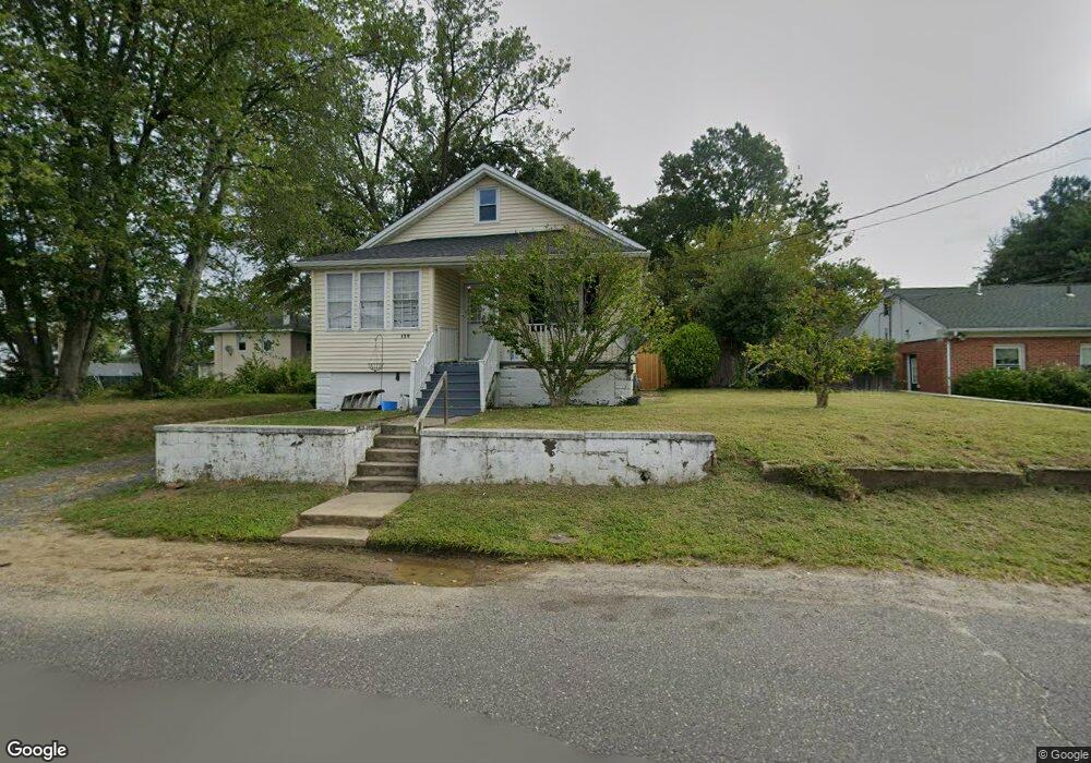
129 Myrtle Ave Long Branch, NJ 07740
Estimated Value: $416,000 - $460,000
1
Bed
1
Bath
960
Sq Ft
$453/Sq Ft
Est. Value
About This Home
This home is located at 129 Myrtle Ave, Long Branch, NJ 07740 and is currently estimated at $435,290, approximately $453 per square foot. 129 Myrtle Ave is a home located in Monmouth County with nearby schools including Long Branch High School and Holy Trinity School.
Ownership History
Date
Name
Owned For
Owner Type
Purchase Details
Closed on
Jun 10, 2004
Sold by
Sperling Scott
Bought by
Mclean Brian
Current Estimated Value
Purchase Details
Closed on
Dec 21, 1999
Sold by
Wellman Charleen
Bought by
Sperling Scott
Home Financials for this Owner
Home Financials are based on the most recent Mortgage that was taken out on this home.
Original Mortgage
$101,850
Interest Rate
7.84%
Create a Home Valuation Report for This Property
The Home Valuation Report is an in-depth analysis detailing your home's value as well as a comparison with similar homes in the area
Home Values in the Area
Average Home Value in this Area
Purchase History
| Date | Buyer | Sale Price | Title Company |
|---|---|---|---|
| Mclean Brian | $160,000 | -- | |
| Sperling Scott | $105,000 | -- |
Source: Public Records
Mortgage History
| Date | Status | Borrower | Loan Amount |
|---|---|---|---|
| Previous Owner | Sperling Scott | $101,850 |
Source: Public Records
Tax History Compared to Growth
Tax History
| Year | Tax Paid | Tax Assessment Tax Assessment Total Assessment is a certain percentage of the fair market value that is determined by local assessors to be the total taxable value of land and additions on the property. | Land | Improvement |
|---|---|---|---|---|
| 2025 | $5,158 | $367,300 | $214,000 | $153,300 |
| 2024 | $4,642 | $335,600 | $189,000 | $146,600 |
| 2023 | $4,642 | $298,900 | $159,000 | $139,900 |
| 2022 | $4,788 | $272,300 | $149,000 | $123,300 |
| 2021 | $4,788 | $239,300 | $124,000 | $115,300 |
| 2020 | $4,694 | $224,600 | $110,000 | $114,600 |
| 2019 | $4,442 | $211,300 | $102,000 | $109,300 |
| 2018 | $4,234 | $200,300 | $95,000 | $105,300 |
| 2017 | $4,709 | $228,500 | $94,000 | $134,500 |
| 2016 | $4,648 | $230,000 | $99,000 | $131,000 |
| 2015 | $4,418 | $198,400 | $100,900 | $97,500 |
| 2014 | $4,207 | $199,100 | $112,600 | $86,500 |
Source: Public Records
Map
Nearby Homes
- 11 Clay St
- 631 Irving Place
- 238 Branchport Ave
- 572 Jay St
- 565 Joline Ave
- 11 Golf St
- 7 Linden Ave
- 119 Washington St
- 28 Norwood Ave
- 88 Norwood Ave
- 222 Coleman Ave
- 13 Morris Place
- 401 Joline Ave
- 2 Hilltop Rd
- 399 Willow Ave
- 190 Spruce St Unit 4
- 75 Poplar Ave
- 148 Sixth Ave
- 14 Slocum Place
- 39 Slocum Place
- 688 Joline Ave
- 678 Joline Ave
- 689 Buttonwood Ave
- 695 Buttonwood Ave
- 691 Buttonwood Ave
- 683 Buttonwood Ave
- 681 Buttonwood Ave
- 109 Myrtle Ave
- 677 Buttonwood Ave
- 690 Buttonwood Ave
- 107 Myrtle Ave
- 675 Buttonwood Ave
- 686 Buttonwood Ave
- 684 Buttonwood Ave
- 682 Buttonwood Ave
- 105 Myrtle Ave
- 680 Buttonwood Ave
- 678 Buttonwood Ave
- 13 Clay St
- 103 Myrtle Ave