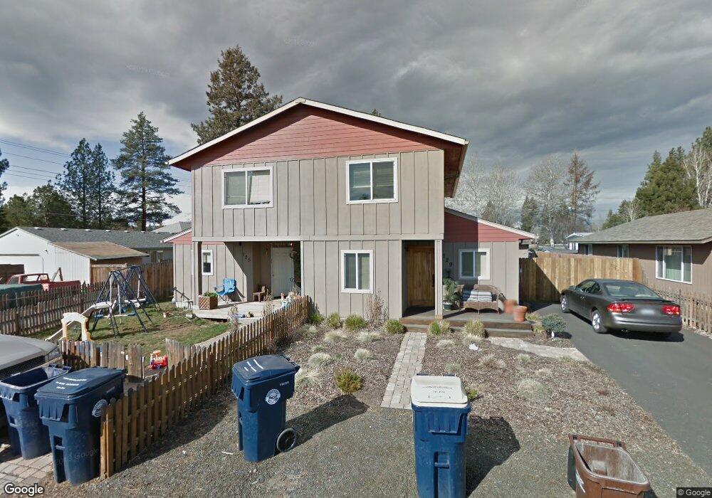
129 N Locust Ln Sisters, OR 97759
Estimated Value: $444,352 - $501,000
2
Beds
2
Baths
1,200
Sq Ft
$392/Sq Ft
Est. Value
About This Home
This home is located at 129 N Locust Ln, Sisters, OR 97759 and is currently estimated at $470,338, approximately $391 per square foot. 129 N Locust Ln is a home located in Deschutes County with nearby schools including Sisters Elementary School, Sisters Middle School, and Sisters High School.
Ownership History
Date
Name
Owned For
Owner Type
Purchase Details
Closed on
Jun 1, 2021
Sold by
Bantz Lizabeth
Bought by
Bantz Lizabeth and The Bantz Revocable Trust
Current Estimated Value
Purchase Details
Closed on
Jan 26, 2007
Sold by
Sisters Habitat For Humanity Inc
Bought by
Bantz Lizabeth
Home Financials for this Owner
Home Financials are based on the most recent Mortgage that was taken out on this home.
Original Mortgage
$95,084
Outstanding Balance
$38,117
Interest Rate
6.1%
Mortgage Type
Seller Take Back
Estimated Equity
$432,221
Purchase Details
Closed on
Jun 9, 2004
Sold by
Mayea Donald A and Mayea Allison J
Bought by
Sisters Habitat For Humanity Inc
Create a Home Valuation Report for This Property
The Home Valuation Report is an in-depth analysis detailing your home's value as well as a comparison with similar homes in the area
Home Values in the Area
Average Home Value in this Area
Purchase History
| Date | Buyer | Sale Price | Title Company |
|---|---|---|---|
| Bantz Lizabeth | -- | None Available | |
| Bantz Lizabeth | $95,084 | Accommodation | |
| Sisters Habitat For Humanity Inc | $60,000 | Western Title & Escrow Co |
Source: Public Records
Mortgage History
| Date | Status | Borrower | Loan Amount |
|---|---|---|---|
| Open | Bantz Lizabeth | $95,084 |
Source: Public Records
Tax History Compared to Growth
Tax History
| Year | Tax Paid | Tax Assessment Tax Assessment Total Assessment is a certain percentage of the fair market value that is determined by local assessors to be the total taxable value of land and additions on the property. | Land | Improvement |
|---|---|---|---|---|
| 2025 | $2,318 | $139,710 | -- | -- |
| 2024 | $2,246 | $135,650 | -- | -- |
| 2023 | $2,182 | $131,700 | $0 | $0 |
| 2022 | $2,028 | $124,150 | $0 | $0 |
| 2021 | $2,050 | $120,540 | $0 | $0 |
| 2020 | $1,949 | $120,540 | $0 | $0 |
| 2019 | $1,901 | $117,030 | $0 | $0 |
| 2018 | $1,839 | $113,630 | $0 | $0 |
| 2017 | $1,776 | $110,330 | $0 | $0 |
| 2016 | $1,751 | $107,120 | $0 | $0 |
| 2015 | $1,644 | $104,000 | $0 | $0 |
| 2014 | $1,590 | $100,980 | $0 | $0 |
Source: Public Records
Map
Nearby Homes
- 363 E Aspenwood Ave
- 352 N Tamarack St
- 0 E Washington Ave Unit 5901 220193407
- 0 N Spruce St
- 325 N Cowboy St
- 923 E Cascade Ave
- 180 S Spruce St
- 380 S Timber Creek Dr
- 946 E Timber Pine Dr
- 1004 E Horse Back Trail
- 557 S Locust St
- 952 E Timber Pine Dr
- 988 E Black Butte Ave Unit 30
- 1094 E Horse Back Trail
- 1110 E Cascade Ave
- 681 S Elm St
- 187 W Jefferson Ave
- 504 Sisters Park Dr Unit Lot 102
- 713 E Tyler Ave
- 285 W Washington Ave
- 139 N Locust Ln
- 125 N Locust Ln
- 119 N Locust Ln
- 159 N Locust Ln
- 130 N Locust St
- 169 N Locust Ln
- 115 N Maple St
- 135 N Maple St
- 189 N Locust Ln
- 145 N Maple St
- 265 E Cascade Ave
- 120 N Locust St
- 211 N Locust Ln
- 241 N Locust Ln
- 239 N Locust Ln
- 240 N Locust Ln
- 111 N Maple St
- 160 N Maple St
- 140 N Maple St
- 110 N Maple St