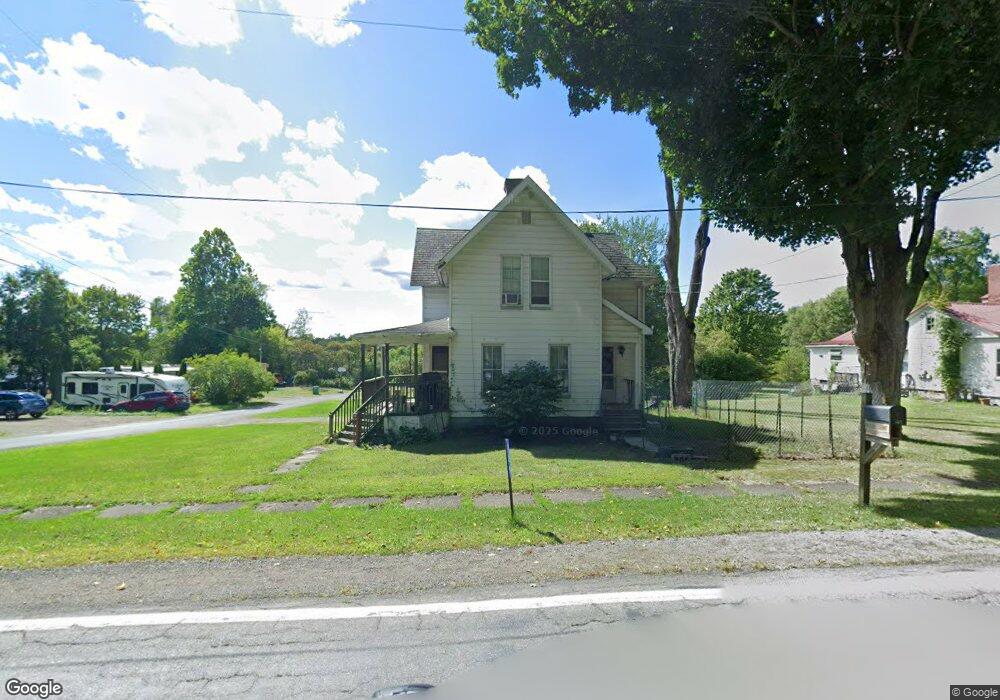
129 N Main St Springboro, PA 16435
Estimated Value: $151,000 - $290,000
--
Bed
--
Bath
--
Sq Ft
0.36
Acres
About This Home
This home is located at 129 N Main St, Springboro, PA 16435 and is currently estimated at $238,532. 129 N Main St is a home located in Crawford County with nearby schools including Conneaut Valley Elementary School, Conneaut Valley Middle School, and Conneaut Area Senior High School.
Ownership History
Date
Name
Owned For
Owner Type
Purchase Details
Closed on
Aug 17, 2023
Sold by
Martin Ronald C and Martin Judith M
Bought by
Donahue Patrick Edward and Peebles Chelsea A
Current Estimated Value
Home Financials for this Owner
Home Financials are based on the most recent Mortgage that was taken out on this home.
Original Mortgage
$211,200
Outstanding Balance
$206,361
Interest Rate
6.78%
Mortgage Type
New Conventional
Estimated Equity
$32,171
Purchase Details
Closed on
Oct 15, 2007
Sold by
Weber Calvin H and Weber June E
Bought by
Birtikids Stacia A
Home Financials for this Owner
Home Financials are based on the most recent Mortgage that was taken out on this home.
Original Mortgage
$15,000
Interest Rate
6.04%
Mortgage Type
New Conventional
Create a Home Valuation Report for This Property
The Home Valuation Report is an in-depth analysis detailing your home's value as well as a comparison with similar homes in the area
Home Values in the Area
Average Home Value in this Area
Purchase History
| Date | Buyer | Sale Price | Title Company |
|---|---|---|---|
| Donahue Patrick Edward | $264,000 | None Listed On Document | |
| Birtikids Stacia A | $75,000 | None Available |
Source: Public Records
Mortgage History
| Date | Status | Borrower | Loan Amount |
|---|---|---|---|
| Open | Donahue Patrick Edward | $211,200 | |
| Previous Owner | Birtikids Stacia A | $15,000 | |
| Previous Owner | Birtikids Stacia A | $60,000 |
Source: Public Records
Tax History Compared to Growth
Tax History
| Year | Tax Paid | Tax Assessment Tax Assessment Total Assessment is a certain percentage of the fair market value that is determined by local assessors to be the total taxable value of land and additions on the property. | Land | Improvement |
|---|---|---|---|---|
| 2025 | $743 | $24,087 | $650 | $23,437 |
| 2024 | $1,937 | $24,087 | $650 | $23,437 |
| 2023 | $1,985 | $24,087 | $650 | $23,437 |
| 2022 | $1,937 | $24,087 | $650 | $23,437 |
| 2021 | $1,937 | $24,087 | $650 | $23,437 |
| 2020 | $1,937 | $24,087 | $650 | $23,437 |
| 2019 | $1,937 | $24,087 | $650 | $23,437 |
| 2018 | $1,846 | $24,087 | $650 | $23,437 |
| 2017 | $1,846 | $24,087 | $650 | $23,437 |
| 2016 | $623 | $24,087 | $650 | $23,437 |
| 2015 | $623 | $24,087 | $650 | $23,437 |
| 2014 | -- | $24,087 | $650 | $23,437 |
Source: Public Records
Map
Nearby Homes
- 605 Washington St
- 1015 Main St
- 410 Center St
- 304 Smith Ave
- 9749 9801 Moses Rd
- 00 Cole Rd
- 0 Winchester Dr Unit 178085
- 0 Winchester Dr Unit 178083
- 23754 S Beaver Rd
- 10023 Reservoir Rd
- 3037 Philadelphia Rd
- 16 Highland Ave
- 86 S Main St
- 95 3rd Ave
- 60 Park Ave
- 10210 Knapp Rd
- Lot3 West Rd
- Lot1 West Rd
- 0 Route 6n
- 11120 West Rd