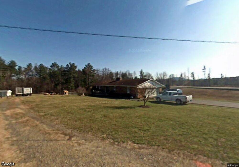
129 Norval Lowe Rd Lowgap, NC 27024
Estimated Value: $233,000 - $277,931
3
Beds
2
Baths
1,505
Sq Ft
$165/Sq Ft
Est. Value
About This Home
This home is located at 129 Norval Lowe Rd, Lowgap, NC 27024 and is currently estimated at $248,310, approximately $164 per square foot. 129 Norval Lowe Rd is a home located in Surry County with nearby schools including Cedar Ridge Elementary School, J. Sam Gentry Middle School, and North Surry High School.
Ownership History
Date
Name
Owned For
Owner Type
Purchase Details
Closed on
Sep 26, 2025
Sold by
Hiatt Jo-Ann Creed and Hiatt Richard Clarence
Bought by
Maines David Logan and Maines Lisa Jane
Current Estimated Value
Home Financials for this Owner
Home Financials are based on the most recent Mortgage that was taken out on this home.
Original Mortgage
$174,400
Outstanding Balance
$174,400
Interest Rate
5.25%
Mortgage Type
New Conventional
Estimated Equity
$73,910
Purchase Details
Closed on
Jun 9, 2025
Sold by
Hiatt Jo-Ann Creed and Hiatt Jo Anne
Bought by
Hiatt Richard C and Hiatt Jo Anne
Purchase Details
Closed on
Apr 1, 1986
Purchase Details
Closed on
Aug 1, 1975
Create a Home Valuation Report for This Property
The Home Valuation Report is an in-depth analysis detailing your home's value as well as a comparison with similar homes in the area
Purchase History
| Date | Buyer | Sale Price | Title Company |
|---|---|---|---|
| Maines David Logan | $235,000 | None Listed On Document | |
| Hiatt Richard C | -- | None Listed On Document | |
| -- | -- | -- | |
| -- | -- | -- |
Source: Public Records
Mortgage History
| Date | Status | Borrower | Loan Amount |
|---|---|---|---|
| Open | Maines David Logan | $174,400 |
Source: Public Records
Tax History
| Year | Tax Paid | Tax Assessment Tax Assessment Total Assessment is a certain percentage of the fair market value that is determined by local assessors to be the total taxable value of land and additions on the property. | Land | Improvement |
|---|---|---|---|---|
| 2025 | $1,043 | $164,470 | $23,100 | $141,370 |
| 2024 | $932 | $135,520 | $23,100 | $112,420 |
| 2023 | $917 | $135,520 | $23,100 | $112,420 |
| 2022 | $917 | $135,520 | $23,100 | $112,420 |
| 2021 | $932 | $135,520 | $23,100 | $112,420 |
| 2020 | $917 | $127,820 | $21,000 | $106,820 |
| 2019 | $914 | $127,820 | $21,000 | $106,820 |
| 2018 | $899 | $127,820 | $0 | $0 |
| 2017 | $894 | $127,820 | $0 | $0 |
| 2016 | $885 | $127,820 | $0 | $0 |
| 2013 | -- | $126,760 | $0 | $0 |
Source: Public Records
Map
Nearby Homes
- TBD Old Mill Rd
- Lots 30 & 31 Morgan Rd
- Lot 18 Mountain View Dr
- Lot 17 Mountain View Dr
- Lot 17 Mountain View Dr Unit 17
- 112 Hardwick Ln
- TBD Courtland Ln
- LOT 35 Baldwin Dr
- 132 Old Nc Highway 89
- 246 & 252 Bear Trail
- 000 Big Rock Ln
- 60 Jonathan Dr
- Lot 33 Jonathan Dr
- TBD W Pine St
- 5216 Peaks Mountain Rd
- TBD Us Hwy 18 N
- TBD Fisher Peak Trail
- 0 Hideaway Cir
- 184 Club House Dr
- 11325 Glade Valley Rd
- 8816 W Pine St Unit STW
- 127 Norval Lowe Rd
- 8866 W Pine St
- 141 Norval Lowe Rd
- 179 Norval Lowe Rd
- 155 Norval Lowe Rd
- 110 Fieldstone Ln
- 8792 W Pine St
- 8890 W Pine St
- 8807 W Pine St
- 8873 W Pine St
- 8793 W Pine St
- 8900 W Pine St
- 8908 W Pine St
- 8772 W Pine St
- 141 Fieldstone Ln
- 8773 W Pine St
- 143 S Oak St
- 189 Fieldstone Ln
- 8920 W Pine St
Your Personal Tour Guide
Ask me questions while you tour the home.