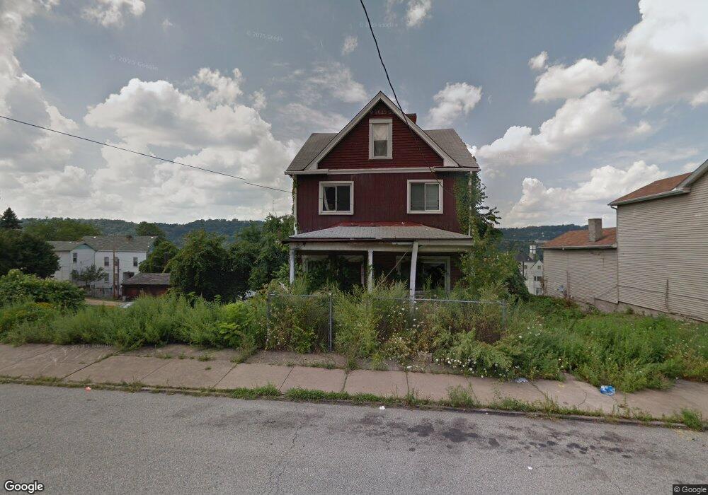
129 W 10th Ave Homestead, PA 15120
Estimated Value: $101,000 - $135,000
5
Beds
3
Baths
2,040
Sq Ft
$60/Sq Ft
Est. Value
About This Home
This home is located at 129 W 10th Ave, Homestead, PA 15120 and is currently estimated at $123,333, approximately $60 per square foot. 129 W 10th Ave is a home located in Allegheny County with nearby schools including Steel Valley Senior High School, Propel Schools - Homestead, and St. Therese School.
Ownership History
Date
Name
Owned For
Owner Type
Purchase Details
Closed on
Nov 14, 2022
Sold by
Mackey Dawn E Est and Williams Jamal
Bought by
Simmons Thomas F 129 W 10Th Ave L L C
Current Estimated Value
Purchase Details
Closed on
Oct 13, 1998
Sold by
Kemp George A and Kemp Joyce
Bought by
Williams Jamal and Mackey Dawn E
Purchase Details
Closed on
Jun 9, 1998
Sold by
Souliler Joseph A
Bought by
Kemp George A and Kemp Joyce
Purchase Details
Closed on
Sep 20, 1989
Bought by
Urbanski Gary J and Urbanski Janine M
Purchase Details
Closed on
Jan 1, 1900
Create a Home Valuation Report for This Property
The Home Valuation Report is an in-depth analysis detailing your home's value as well as a comparison with similar homes in the area
Home Values in the Area
Average Home Value in this Area
Purchase History
| Date | Buyer | Sale Price | Title Company |
|---|---|---|---|
| Simmons Thomas F 129 W 10Th Ave L L C | $23,707 | -- | |
| Williams Jamal | $23,000 | -- | |
| Kemp George A | $15,000 | -- | |
| Urbanski Gary J | $18,000 | -- | |
| -- | -- | -- |
Source: Public Records
Tax History Compared to Growth
Tax History
| Year | Tax Paid | Tax Assessment Tax Assessment Total Assessment is a certain percentage of the fair market value that is determined by local assessors to be the total taxable value of land and additions on the property. | Land | Improvement |
|---|---|---|---|---|
| 2025 | $721 | $15,100 | $2,800 | $12,300 |
| 2024 | $721 | $15,100 | $2,800 | $12,300 |
| 2023 | $665 | $15,100 | $2,800 | $12,300 |
| 2022 | $667 | $15,100 | $2,800 | $12,300 |
| 2021 | $71 | $15,100 | $2,800 | $12,300 |
| 2020 | $638 | $15,100 | $2,800 | $12,300 |
| 2019 | $627 | $15,100 | $2,800 | $12,300 |
| 2018 | $71 | $15,100 | $2,800 | $12,300 |
| 2017 | $605 | $15,100 | $2,800 | $12,300 |
| 2016 | $71 | $15,100 | $2,800 | $12,300 |
| 2015 | $71 | $15,100 | $2,800 | $12,300 |
| 2014 | $594 | $15,100 | $2,800 | $12,300 |
Source: Public Records
Map
Nearby Homes
- 225 W 10th Ave
- 315 W 12th Ave
- 200 E 8th Ave
- 215 E 9th Ave
- 206 W 13th Ave
- 402 W 8th Ave
- 407-409 W 8th Ave
- 337 E 12th Ave
- 235 - 237 E 8th Ave
- 342 E 11th Ave
- 139 W 16th Ave
- 343 E 12th Ave
- 124 E 15th Ave
- 346 E 12th Ave
- 227 E 15th Ave
- 815 Mcclure St
- 473 New 8th Ave
- 246 E 14th Ave
- 122 E 16th Ave
- 230 E 15th Ave
- 131 W 10th Ave
- 123 W 10th Ave
- 128 W Locust Way
- 124 W Locust Way
- 119 W 10th Ave
- 128 W 10th Ave
- 141 W 10th Ave
- 132 W 10th Ave
- 117 W 10th Ave
- 134 W 10th Ave
- 122 W 10th Ave
- 126 W 10th Ave
- 138 W 10th Ave
- 143 W 10th Ave
- 145 W 10th Ave
- 118 W 10th Ave
- 136 W 9th Ave
- 132 W 9th Ave
- 124 W 9th Ave
- 147 W 10th Ave