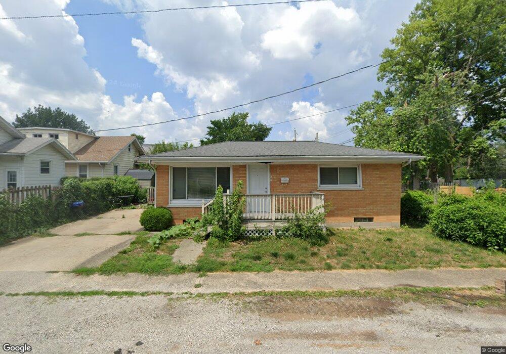
129 W Myrtle St Springfield, IL 62704
Grand Central NeighborhoodEstimated Value: $62,102 - $104,000
2
Beds
1
Bath
816
Sq Ft
$90/Sq Ft
Est. Value
About This Home
This home is located at 129 W Myrtle St, Springfield, IL 62704 and is currently estimated at $73,776, approximately $90 per square foot. 129 W Myrtle St is a home located in Sangamon County with nearby schools including Black Hawk Elementary School, Jefferson Middle School, and Springfield Southeast High School.
Ownership History
Date
Name
Owned For
Owner Type
Purchase Details
Closed on
Mar 1, 2011
Current Estimated Value
Purchase Details
Closed on
Feb 25, 2011
Purchase Details
Closed on
Jan 27, 2010
Purchase Details
Closed on
Jul 25, 2006
Purchase Details
Closed on
May 5, 2005
Purchase Details
Closed on
Dec 6, 2004
Purchase Details
Closed on
Dec 3, 2004
Purchase Details
Closed on
Jun 14, 2002
Purchase Details
Closed on
Mar 22, 2001
Purchase Details
Closed on
Jul 16, 1999
Purchase Details
Closed on
Jul 7, 1994
Create a Home Valuation Report for This Property
The Home Valuation Report is an in-depth analysis detailing your home's value as well as a comparison with similar homes in the area
Home Values in the Area
Average Home Value in this Area
Purchase History
| Date | Buyer | Sale Price | Title Company |
|---|---|---|---|
| -- | -- | -- | |
| -- | $20,000 | -- | |
| -- | -- | -- | |
| -- | -- | -- | |
| -- | $38,000 | -- | |
| -- | $44,500 | -- | |
| -- | $11,300 | -- | |
| -- | $11,300 | -- | |
| -- | -- | -- | |
| -- | -- | -- | |
| -- | $35,000 | -- | |
| -- | $32,000 | -- |
Source: Public Records
Tax History
| Year | Tax Paid | Tax Assessment Tax Assessment Total Assessment is a certain percentage of the fair market value that is determined by local assessors to be the total taxable value of land and additions on the property. | Land | Improvement |
|---|---|---|---|---|
| 2024 | $1,279 | $15,229 | $2,902 | $12,327 |
| 2023 | $1,230 | $13,911 | $2,651 | $11,260 |
| 2022 | $1,182 | $13,196 | $2,515 | $10,681 |
| 2021 | $1,143 | $12,702 | $2,421 | $10,281 |
| 2020 | $1,121 | $12,721 | $2,425 | $10,296 |
| 2019 | $1,100 | $12,677 | $2,417 | $10,260 |
| 2018 | $875 | $10,357 | $2,406 | $7,951 |
| 2017 | $857 | $10,223 | $2,375 | $7,848 |
| 2016 | $840 | $10,074 | $2,340 | $7,734 |
| 2015 | $832 | $9,954 | $2,312 | $7,642 |
| 2014 | $884 | $9,890 | $2,297 | $7,593 |
| 2013 | $1,109 | $13,682 | $2,296 | $11,386 |
Source: Public Records
Map
Nearby Homes
- 1708 S Spring St
- 1728 S Spring St
- 1801 S 1st St
- 1901 S 1st St
- 1920 S Pasfield St
- 2001 S Spring St
- 1912 S Whittier Ave
- 1817 S Whittier Ave
- 1740 S Lowell Ave
- 1711 S 5th St
- 1935 S 5th St
- 452 S Grand Ave W
- 2136 S Whittier Ave
- 526 S Grand Ave W
- 534 W Vine St
- 1601 S Glenwood Ave
- 725 E Spruce St
- 37 Belle Place
- 706 South Grand Ave W
- 2321 S Pasfield St
- 1732 S Spring St
- 119 W Myrtle St
- 1724 S Spring St
- 1800 S Spring St
- 122 W Myrtle St
- 115 W Myrtle St
- 1720 S Spring St
- 118 W Myrtle St
- 1804 S Spring St
- 120 W Myrtle St
- 1716 S Spring St
- 1808 S Spring St
- 1712 S Spring St
- 1737 S Spring St
- 1733 S Spring St
- 1729 S Spring St
- 110 W Laurel St
- 1725 S Spring St
- 1812 S Spring St
- 1801 S Spring St
Your Personal Tour Guide
Ask me questions while you tour the home.