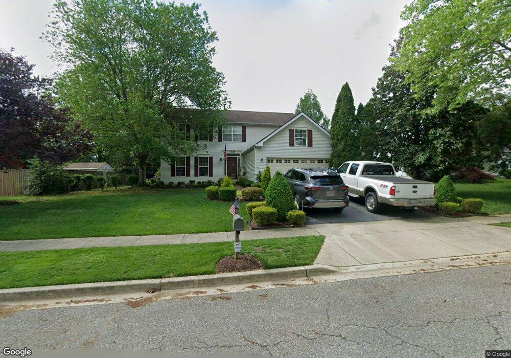
12905 Rhine Rd Upper Marlboro, MD 20772
Estimated Value: $531,554 - $629,000
Studio
3
Baths
2,500
Sq Ft
$237/Sq Ft
Est. Value
About This Home
This home is located at 12905 Rhine Rd, Upper Marlboro, MD 20772 and is currently estimated at $592,639, approximately $237 per square foot. 12905 Rhine Rd is a home located in Prince George's County with nearby schools including Barack Obama Elementary School, James Madison Middle School, and Dr. Henry A. Wise Jr. High School.
Ownership History
Date
Name
Owned For
Owner Type
Purchase Details
Closed on
Mar 6, 1995
Sold by
Richmond American Homes Maryland
Bought by
Randol Dirk E
Current Estimated Value
Home Financials for this Owner
Home Financials are based on the most recent Mortgage that was taken out on this home.
Original Mortgage
$185,800
Interest Rate
8.96%
Create a Home Valuation Report for This Property
The Home Valuation Report is an in-depth analysis detailing your home's value as well as a comparison with similar homes in the area
Home Values in the Area
Average Home Value in this Area
Purchase History
| Date | Buyer | Sale Price | Title Company |
|---|---|---|---|
| Randol Dirk E | $233,000 | -- |
Source: Public Records
Mortgage History
| Date | Status | Borrower | Loan Amount |
|---|---|---|---|
| Closed | Randol Dirk E | $185,800 |
Source: Public Records
Tax History
| Year | Tax Paid | Tax Assessment Tax Assessment Total Assessment is a certain percentage of the fair market value that is determined by local assessors to be the total taxable value of land and additions on the property. | Land | Improvement |
|---|---|---|---|---|
| 2025 | $5,791 | $505,900 | $126,800 | $379,100 |
| 2024 | $5,791 | $457,333 | -- | -- |
| 2023 | $5,498 | $408,767 | $0 | $0 |
| 2022 | $5,165 | $360,200 | $101,800 | $258,400 |
| 2021 | $4,970 | $349,567 | $0 | $0 |
| 2020 | $4,889 | $338,933 | $0 | $0 |
| 2019 | $4,782 | $328,300 | $100,900 | $227,400 |
| 2018 | $4,641 | $316,033 | $0 | $0 |
| 2017 | $4,528 | $303,767 | $0 | $0 |
| 2016 | -- | $291,500 | $0 | $0 |
| 2015 | $4,754 | $291,500 | $0 | $0 |
| 2014 | $4,754 | $291,500 | $0 | $0 |
Source: Public Records
Map
Nearby Homes
- 4317 Stockport Way
- 13192 Ripon Place
- 4411 Beckenham Place
- 4482 Lord Loudoun Ct
- 14000 Lord Marlborough Place
- 13915 Lord Fairfax Place
- 13825 King Frederick Way
- 4316 Reverend Eversfield Ct
- 13900 King George Way
- 3204 Carlene Ct
- 5005 Kennington Ct
- 14134 Reverend Rainsford Ct
- 5105 Mapleshade Ln
- 5101 Back Stretch Blvd
- 13900 Farnsworth Ln Unit 4301
- 3901 Largo Rd
- 14100 Farnsworth Ln
- 5209 Mount Airy Ln
- 4001 Largo Rd
- 13500 Old Marlboro Pike
- 12903 Rhine Rd
- 12907 Rhine Rd
- 4307 Sutherland Cir
- 4309 Sutherland Cir
- 4702 Halloran Ct
- 4704 Halloran Ct
- 4700 Halloran Ct
- 4311 Sutherland Cir
- 12906 Rhine Rd
- 12908 Rhine Rd
- 4706 Halloran Ct
- 12904 Rhine Rd
- 12900 Rhine Rd
- 4301 Sutherland Cir
- 12902 Rhine Rd
- 4306 Sutherland Cir
- 4308 Sutherland Cir
- 4300 Sutherland Cir
- 4313 Sutherland Cir
- 4310 Sutherland Cir
Your Personal Tour Guide
Ask me questions while you tour the home.