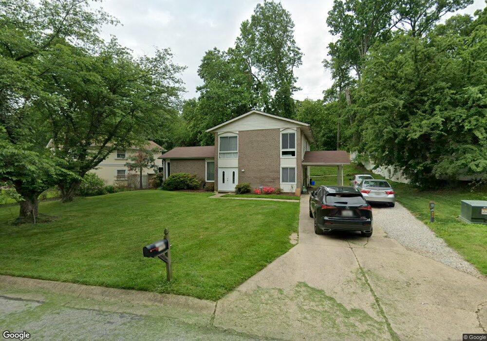
12908 Autumn Dr Silver Spring, MD 20904
Estimated Value: $505,000 - $679,000
Studio
3
Baths
2,264
Sq Ft
$266/Sq Ft
Est. Value
About This Home
This home is located at 12908 Autumn Dr, Silver Spring, MD 20904 and is currently estimated at $601,756, approximately $265 per square foot. 12908 Autumn Dr is a home located in Montgomery County with nearby schools including Cannon Road Elementary School, Francis Scott Key Middle School, and Springbrook High School.
Ownership History
Date
Name
Owned For
Owner Type
Purchase Details
Closed on
May 17, 2011
Sold by
Kessie George and Morrison Agnes Emma
Bought by
Morrison Agnes Emma
Current Estimated Value
Purchase Details
Closed on
Sep 29, 2003
Sold by
Prichard Woodward C and Prichard S E
Bought by
Kessie George and Morrison Agnes E
Create a Home Valuation Report for This Property
The Home Valuation Report is an in-depth analysis detailing your home's value as well as a comparison with similar homes in the area
Home Values in the Area
Average Home Value in this Area
Purchase History
| Date | Buyer | Sale Price | Title Company |
|---|---|---|---|
| Morrison Agnes Emma | -- | None Available | |
| Kessie George | $309,500 | -- | |
| Kessie George | $309,500 | -- |
Source: Public Records
Tax History
| Year | Tax Paid | Tax Assessment Tax Assessment Total Assessment is a certain percentage of the fair market value that is determined by local assessors to be the total taxable value of land and additions on the property. | Land | Improvement |
|---|---|---|---|---|
| 2025 | $5,611 | $475,833 | -- | -- |
| 2024 | $5,611 | $434,667 | $0 | $0 |
| 2023 | $5,805 | $393,500 | $220,200 | $173,300 |
| 2022 | $4,117 | $387,300 | $0 | $0 |
| 2021 | $3,881 | $381,100 | $0 | $0 |
| 2020 | $3,881 | $374,900 | $220,200 | $154,700 |
| 2019 | $3,721 | $362,800 | $0 | $0 |
| 2018 | $3,569 | $350,700 | $0 | $0 |
| 2017 | $3,711 | $338,600 | $0 | $0 |
| 2016 | $3,527 | $326,500 | $0 | $0 |
| 2015 | $3,527 | $314,400 | $0 | $0 |
| 2014 | $3,527 | $302,300 | $0 | $0 |
Source: Public Records
Map
Nearby Homes
- 605 Rosemere Ave
- 816 Rosemere Ave
- 606 Winhall Way
- 7 Shaw Ave
- 12916 Shaw Place
- 906 Venice Dr
- 13137 Broadmore Rd
- 1306 Leister Dr
- 12624 Billington Rd
- 13707 Notley Rd
- 13704 New Hampshire Ave
- 1407 Northcrest Dr
- 13711 Notley Rd
- 13715 Notley Rd
- 13719 Notley Rd
- 115 Lillian Ln
- 600 Seminole Creek Way
- 1116 Tiffany Rd
- 12405 Olivewood Place
- 609 Seminole Creek Way
- 617 Deerhead Ct
- 12906 Autumn Dr
- 616 Eldrid Dr
- 618 Eldrid Dr
- 614 Eldrid Dr
- 12900 Chathlake Ln
- 613 Deerhead Ct
- 12911 Autumn Dr
- 12901 Chathlake Ln
- 612 Eldrid Dr
- 12914 Autumn Dr
- 611 Deerhead Ct
- 12902 Chathlake Ln
- 12903 Autumn Dr
- 12913 Autumn Dr
- 610 Eldrid Dr
- 12901 Autumn Dr
- 12903 Chathlake Ln
- 609 Deerhead Ct
- 610 Deerhead Ct
Your Personal Tour Guide
Ask me questions while you tour the home.