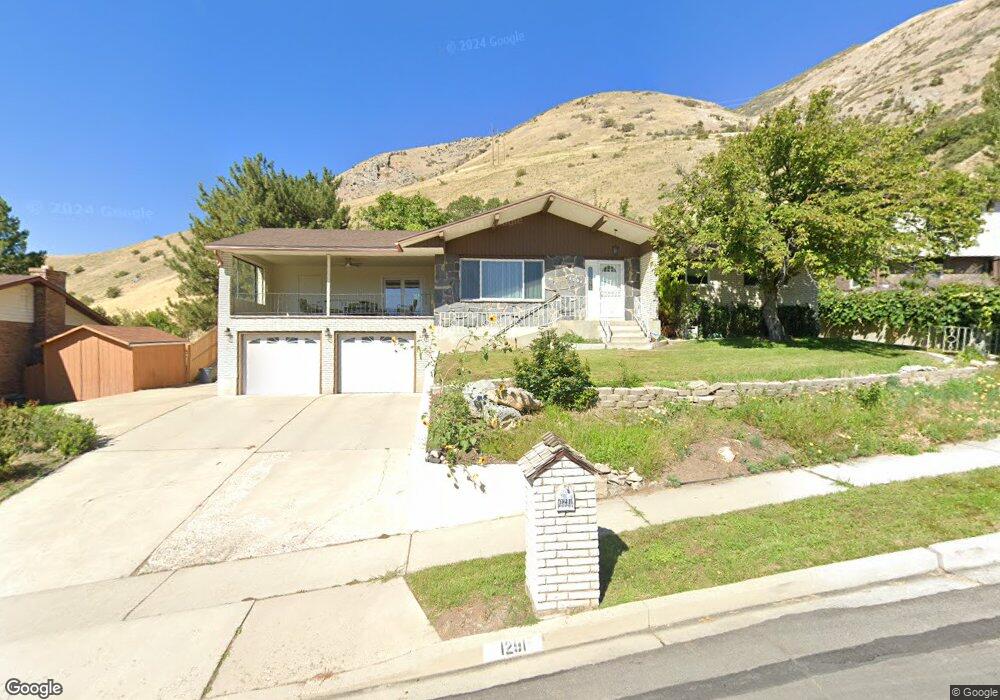
1291 E 225 N Springville, UT 84663
Estimated Value: $596,000 - $605,023
5
Beds
3
Baths
3,296
Sq Ft
$182/Sq Ft
Est. Value
About This Home
This home is located at 1291 E 225 N, Springville, UT 84663 and is currently estimated at $600,008, approximately $182 per square foot. 1291 E 225 N is a home located in Utah County with nearby schools including Art City School, Springville Junior High School, and Springville High School.
Ownership History
Date
Name
Owned For
Owner Type
Purchase Details
Closed on
Aug 29, 2022
Sold by
Delone Muir Family Trust and Parker Kathy
Bought by
Bassett Lance Andre
Current Estimated Value
Purchase Details
Closed on
Aug 26, 2022
Sold by
Elmo R Muir Family Trust
Bought by
Bassett Lance Andre
Purchase Details
Closed on
Mar 27, 2018
Sold by
Mu9ir Richard B and The Elmo R Muir Family Trust
Bought by
Muir Richard B and Parker Kathy
Purchase Details
Closed on
Aug 30, 2013
Sold by
Muir Elmo R and Muir Delone
Bought by
Muir Elmo R and Muir Delone
Create a Home Valuation Report for This Property
The Home Valuation Report is an in-depth analysis detailing your home's value as well as a comparison with similar homes in the area
Home Values in the Area
Average Home Value in this Area
Purchase History
| Date | Buyer | Sale Price | Title Company |
|---|---|---|---|
| Bassett Lance Andre | -- | Real Advantage Title | |
| Bassett Lance Andre | -- | Real Advantage Title | |
| Bassett Lance Andre | -- | -- | |
| Bassett Lance Andre | -- | Real Advantage Title | |
| Muir Richard B | -- | None Available | |
| Muir Elmo R | -- | None Available |
Source: Public Records
Tax History
| Year | Tax Paid | Tax Assessment Tax Assessment Total Assessment is a certain percentage of the fair market value that is determined by local assessors to be the total taxable value of land and additions on the property. | Land | Improvement |
|---|---|---|---|---|
| 2025 | $2,608 | $311,300 | -- | -- |
| 2024 | $2,608 | $267,135 | $0 | $0 |
| 2023 | $2,466 | $252,945 | $0 | $0 |
| 2022 | $2,650 | $266,915 | $0 | $0 |
| 2021 | $2,326 | $364,700 | $111,500 | $253,200 |
| 2020 | $2,232 | $339,200 | $92,900 | $246,300 |
| 2019 | $2,086 | $322,700 | $85,500 | $237,200 |
| 2018 | $2,014 | $297,300 | $81,800 | $215,500 |
| 2017 | $1,844 | $144,595 | $0 | $0 |
| 2016 | $1,716 | $131,945 | $0 | $0 |
| 2015 | $1,664 | $130,735 | $0 | $0 |
| 2014 | $1,472 | $114,950 | $0 | $0 |
Source: Public Records
Map
Nearby Homes
- 1027 E 200 N
- 926 E 250 N
- 1185 Hillcrest Dr
- 1130 Hillcrest Dr
- 1062 E 350 S
- 1361 E 400 S
- 1783 E Spring Oaks Dr N Unit 12 & 1
- 711 E 400 N
- 1800 Spring Oaks Dr
- 663 N 880 E
- 437 N 650 St E
- 802 S Brookside Dr
- 519 N 600 E
- 805 E 400 S
- 616 E Aaron Ave
- 557 S 1470 E
- 380 E 200 N
- 66 E 750 S Unit 23
- 883 E 700 S
- 645 Swenson Ave Unit 5
Your Personal Tour Guide
Ask me questions while you tour the home.