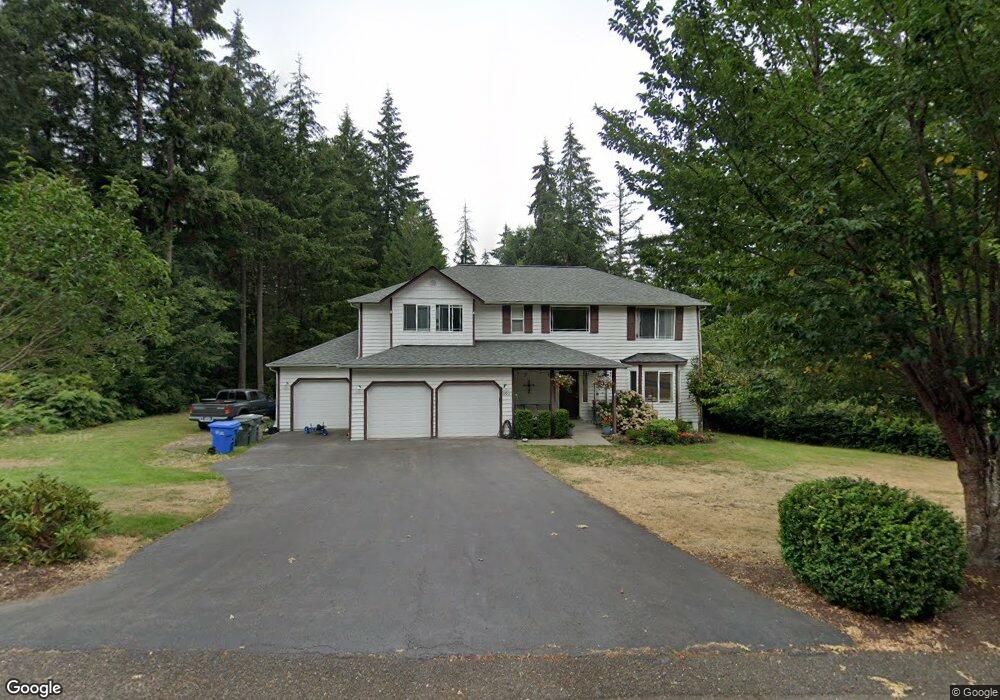
12911 132nd Avenue Kp N Gig Harbor, WA 98329
Estimated Value: $752,250 - $784,000
4
Beds
3
Baths
2,560
Sq Ft
$298/Sq Ft
Est. Value
About This Home
This home is located at 12911 132nd Avenue Kp N, Gig Harbor, WA 98329 and is currently estimated at $763,813, approximately $298 per square foot. 12911 132nd Avenue Kp N is a home located in Pierce County with nearby schools including Vaughn Elementary School, Key Peninsula Middle School, and Peninsula High School.
Ownership History
Date
Name
Owned For
Owner Type
Purchase Details
Closed on
Jun 20, 2020
Sold by
Kearney Lynelle Scheid and Kearney Lynelle A
Bought by
Thomas Brandon and Thomas Emily
Current Estimated Value
Home Financials for this Owner
Home Financials are based on the most recent Mortgage that was taken out on this home.
Original Mortgage
$337,968
Outstanding Balance
$299,583
Interest Rate
3.2%
Mortgage Type
New Conventional
Estimated Equity
$464,230
Purchase Details
Closed on
Feb 17, 2011
Sold by
Kearney Steven B and Kearney Lynelle Scheid
Bought by
Kearney Lynelle Scheid
Purchase Details
Closed on
Sep 11, 2000
Sold by
Ferguson & Cole Inc
Bought by
Kearney Steven
Home Financials for this Owner
Home Financials are based on the most recent Mortgage that was taken out on this home.
Original Mortgage
$200,700
Interest Rate
8.62%
Create a Home Valuation Report for This Property
The Home Valuation Report is an in-depth analysis detailing your home's value as well as a comparison with similar homes in the area
Home Values in the Area
Average Home Value in this Area
Purchase History
| Date | Buyer | Sale Price | Title Company |
|---|---|---|---|
| Thomas Brandon | $519,950 | Wfg National Title | |
| Kearney Lynelle Scheid | -- | None Available | |
| Kearney Steven | $223,000 | Land Title Company | |
| Kearney Steven | -- | Land Title Company |
Source: Public Records
Mortgage History
| Date | Status | Borrower | Loan Amount |
|---|---|---|---|
| Open | Thomas Brandon | $337,968 | |
| Previous Owner | Kearney Steven | $200,700 |
Source: Public Records
Tax History Compared to Growth
Tax History
| Year | Tax Paid | Tax Assessment Tax Assessment Total Assessment is a certain percentage of the fair market value that is determined by local assessors to be the total taxable value of land and additions on the property. | Land | Improvement |
|---|---|---|---|---|
| 2025 | $5,648 | $697,500 | $225,800 | $471,700 |
| 2024 | $5,648 | $640,600 | $231,900 | $408,700 |
| 2023 | $5,648 | $624,600 | $253,900 | $370,700 |
| 2022 | $5,491 | $627,600 | $238,000 | $389,600 |
| 2021 | $4,996 | $461,500 | $134,300 | $327,200 |
| 2019 | $4,097 | $410,600 | $101,500 | $309,100 |
| 2018 | $3,877 | $383,000 | $88,700 | $294,300 |
| 2017 | $3,877 | $349,800 | $76,900 | $272,900 |
| 2016 | $3,489 | $296,100 | $66,700 | $229,400 |
| 2014 | $3,320 | $276,500 | $61,900 | $214,600 |
| 2013 | $3,320 | $262,500 | $58,100 | $204,400 |
Source: Public Records
Map
Nearby Homes
- 12718 131st St NW
- 12901 122nd Ave NW
- 13721 137th St NW
- 14014 131st St NW
- 13112 Grouse Hollow Dr NW
- 13202 142nd Ave NW
- 13916 140th Ave NW
- 12711 144th Ave NW
- 13619 Sandy Point East NW
- 14413 134th St NW
- 13257 118th Ave NW
- 13510 145th Ave NW
- 18703 Washington 302
- 5301 Washington 302
- 3151 Washington 302
- 13617 144th St NW
- 14720 Parkdale Dr NW
- 12211 110th St NW
- 11019 136th St NW
- 0 154th Ave NW Unit NWM2322039
- 12911 132nd Avenue Kp N Unit KN
- 12911 132nd Ave NW
- 12915 132nd Avenue Kp N
- 12915 132nd Avenue Kp N Unit KN
- 12907 132nd Ave NW Unit KN
- 12925 132nd Ave NW Unit KN
- 121911 132nd Ave NW
- 12903 132nd Ave NW
- 12903 132nd Ave NW
- 12903 132nd Ave NW Unit KN
- 13208 130th Street Kp N Unit KN
- 12906 132nd Avenue Kp N
- 12906 132nd Avenue Kp N Unit KN
- 12906 132nd Ave NW
- 12919 State Route 302 Kpn
- 7507 Goodrich
- 0 118th St NW
- 0 XXX Rocky Crk Rd
- 14701 106th Stct Kpn
- 313