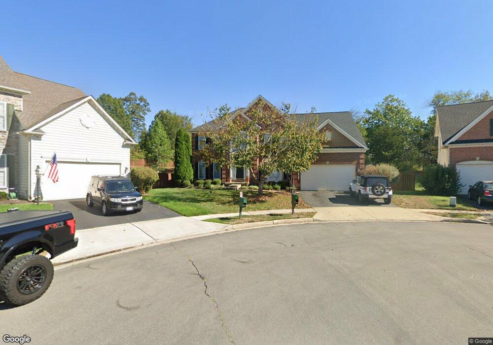
12920 Roberts Ridge Ct Bristow, VA 20136
Estimated Value: $902,000 - $1,000,000
4
Beds
5
Baths
4,118
Sq Ft
$229/Sq Ft
Est. Value
About This Home
This home is located at 12920 Roberts Ridge Ct, Bristow, VA 20136 and is currently estimated at $941,105, approximately $228 per square foot. 12920 Roberts Ridge Ct is a home located in Prince William County with nearby schools including Bristow Run Elementary School, Patriot High School, and Gainesville Middle School.
Ownership History
Date
Name
Owned For
Owner Type
Purchase Details
Closed on
Nov 30, 2006
Sold by
Nvr Inc
Bought by
Martinez Rafael
Current Estimated Value
Home Financials for this Owner
Home Financials are based on the most recent Mortgage that was taken out on this home.
Original Mortgage
$540,900
Outstanding Balance
$324,288
Interest Rate
6.36%
Mortgage Type
New Conventional
Estimated Equity
$616,817
Create a Home Valuation Report for This Property
The Home Valuation Report is an in-depth analysis detailing your home's value as well as a comparison with similar homes in the area
Home Values in the Area
Average Home Value in this Area
Purchase History
| Date | Buyer | Sale Price | Title Company |
|---|---|---|---|
| Martinez Rafael | $676,170 | -- |
Source: Public Records
Mortgage History
| Date | Status | Borrower | Loan Amount |
|---|---|---|---|
| Open | Martinez Rafael | $540,900 |
Source: Public Records
Tax History Compared to Growth
Tax History
| Year | Tax Paid | Tax Assessment Tax Assessment Total Assessment is a certain percentage of the fair market value that is determined by local assessors to be the total taxable value of land and additions on the property. | Land | Improvement |
|---|---|---|---|---|
| 2025 | $7,978 | $895,200 | $240,600 | $654,600 |
| 2024 | $7,978 | $802,200 | $209,700 | $592,500 |
| 2023 | $8,111 | $779,500 | $206,000 | $573,500 |
| 2022 | $8,046 | $716,200 | $188,600 | $527,600 |
| 2021 | $7,188 | $591,100 | $142,600 | $448,500 |
| 2020 | $8,748 | $564,400 | $130,100 | $434,300 |
| 2019 | $8,362 | $539,500 | $130,100 | $409,400 |
| 2018 | $5,986 | $495,700 | $124,000 | $371,700 |
| 2017 | $6,009 | $488,900 | $124,000 | $364,900 |
| 2016 | $5,974 | $490,800 | $124,000 | $366,800 |
| 2015 | $5,797 | $483,700 | $124,000 | $359,700 |
| 2014 | $5,797 | $465,800 | $119,300 | $346,500 |
Source: Public Records
Map
Nearby Homes
- 9061 Slate Stone Loop
- 9478 Merrimont Trace Cir
- 9107 Kearney Place
- 9256 Crestview Ridge Dr
- 9318 Crestview Ridge Dr
- 9244 Crestview Ridge Dr
- 9293 Crestview Ridge Dr
- 9381 Crestview Ridge Dr
- 9475 Sarah Mill Terrace
- 8831 Howland Place
- 12441 Great Falls Dr
- 8800 Fenimore Place
- 8768 Dunstable Loop
- 10045 Pentland Hills Way
- Hampton II Plan at Parkgate Estates
- 12324 Malvern Way
- 8537 Trade Wind Ct
- 12100 Brevard Park Ct
- 13714 Jabielle Terrace
- 8411 Lanier Overlook Ct
- 12924 Roberts Ridge Ct
- 12919 Roberts Ridge Ct
- 12928 Roberts Ridge Ct
- 12923 Roberts Ridge Ct
- 12912 Hunting Cove Place
- 12927 Roberts Ridge Ct
- 12932 Roberts Ridge Ct
- 12931 Roberts Ridge Ct
- 9191 Rilda Place
- 9181 Rilda Place
- 12936 Roberts Ridge Ct
- 9171 Rilda Place
- 12908 Hunting Cove Place
- 12904 Hunting Cove Place
- 9163 Rilda Place
- 12935 Roberts Ridge Ct
- 9193 Rilda Place
- 12900 Hunting Cove Place
- 9081 Linton Hall Rd
- 9201 Rilda Place