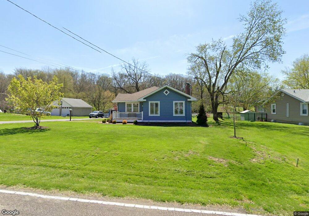
12930 W Watson Rd Saint Louis, MO 63127
Estimated Value: $318,000 - $446,000
2
Beds
1
Bath
1,894
Sq Ft
$201/Sq Ft
Est. Value
About This Home
This home is located at 12930 W Watson Rd, Saint Louis, MO 63127 and is currently estimated at $380,746, approximately $201 per square foot. 12930 W Watson Rd is a home located in St. Louis County with nearby schools including Concord Elementary School, Sperreng Middle School, and Lindbergh High School.
Ownership History
Date
Name
Owned For
Owner Type
Purchase Details
Closed on
Jan 25, 2002
Sold by
Seabaugh Victor B and Seabaugh Nicole
Bought by
Seabaugh Victor B and Seabaugh Nicole
Current Estimated Value
Home Financials for this Owner
Home Financials are based on the most recent Mortgage that was taken out on this home.
Original Mortgage
$139,500
Interest Rate
7.15%
Create a Home Valuation Report for This Property
The Home Valuation Report is an in-depth analysis detailing your home's value as well as a comparison with similar homes in the area
Home Values in the Area
Average Home Value in this Area
Purchase History
| Date | Buyer | Sale Price | Title Company |
|---|---|---|---|
| Seabaugh Victor B | -- | -- |
Source: Public Records
Mortgage History
| Date | Status | Borrower | Loan Amount |
|---|---|---|---|
| Closed | Seabaugh Victor B | $139,500 |
Source: Public Records
Tax History Compared to Growth
Tax History
| Year | Tax Paid | Tax Assessment Tax Assessment Total Assessment is a certain percentage of the fair market value that is determined by local assessors to be the total taxable value of land and additions on the property. | Land | Improvement |
|---|---|---|---|---|
| 2025 | $4,038 | $62,550 | $27,650 | $34,900 |
| 2024 | $4,038 | $56,470 | $20,730 | $35,740 |
| 2023 | $4,029 | $56,470 | $20,730 | $35,740 |
| 2022 | $3,569 | $48,110 | $20,960 | $27,150 |
| 2021 | $3,551 | $48,110 | $20,960 | $27,150 |
| 2020 | $2,724 | $35,630 | $17,330 | $18,300 |
| 2019 | $2,717 | $35,630 | $17,330 | $18,300 |
| 2018 | $2,363 | $28,970 | $10,790 | $18,180 |
| 2017 | $2,339 | $28,990 | $10,790 | $18,200 |
| 2016 | $2,238 | $27,760 | $10,790 | $16,970 |
| 2015 | $2,209 | $27,760 | $10,790 | $16,970 |
| 2014 | $2,742 | $33,970 | $5,150 | $28,820 |
Source: Public Records
Map
Nearby Homes
- 12795 Nanell Ln
- 12981 Baalbek Dr
- 13025 Stone Castle Ct
- 12830 Weber Hill Rd
- 13013 Stone Castle Ct
- 13355 Maple Dr
- 9129 Rott Rd
- 0 Unknown Unit MIS25071866
- 0 Unknown Unit MIS25071884
- 13310 W Watson Rd
- 12685 Alberts Laumeier Ct
- 11226 Pointe Ct
- 12817 Pointe Dr
- 12420 Rott Rd Unit 1B
- 3906 Courtyard Place Dr
- 10225 E Watson Rd
- 12224 Bird Haven Ln
- 118 Monica Dr
- 119 Monica Dr
- 10755 Kennerly Rd
- 12936 W Watson Rd
- 12920 W Watson Rd
- 12870 Nanell Ln
- 12854 Nanell Ln
- 12925 W Watson Rd
- 12935 W Watson Rd
- 12828 Sunset Glen Estate
- 12828 Sunset Glen Estates
- 12816 Nanell Ln
- 12915 W Watson Rd
- 12616 Nanell Ln
- 12815 Sunset Glen Estate
- 12955 W Watson Rd
- 12869 Nanell Ln
- 12812 Sunset Glen Estate
- 12855 Nanell Ln
- 13004 W Watson Rd
- 12843 Nanell Ln
- 12962 Baalbek Dr
- 12804 Nanell Ln