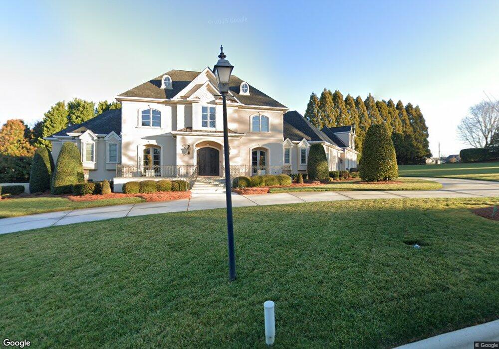
1294 Audubon Dr Gastonia, NC 28054
Estimated Value: $866,000 - $1,143,634
4
Beds
5
Baths
5,150
Sq Ft
$190/Sq Ft
Est. Value
About This Home
This home is located at 1294 Audubon Dr, Gastonia, NC 28054 and is currently estimated at $978,545, approximately $190 per square foot. 1294 Audubon Dr is a home located in Gaston County with nearby schools including Sherwood Elementary School, W P Grier Middle School, and Ashbrook High School.
Ownership History
Date
Name
Owned For
Owner Type
Purchase Details
Closed on
Jun 29, 2012
Sold by
Cherry Christopher G and Cherry Donna
Bought by
Lawrence James Daniel and Lawrence Paula G
Current Estimated Value
Home Financials for this Owner
Home Financials are based on the most recent Mortgage that was taken out on this home.
Original Mortgage
$475,000
Interest Rate
3.83%
Mortgage Type
Purchase Money Mortgage
Create a Home Valuation Report for This Property
The Home Valuation Report is an in-depth analysis detailing your home's value as well as a comparison with similar homes in the area
Home Values in the Area
Average Home Value in this Area
Purchase History
| Date | Buyer | Sale Price | Title Company |
|---|---|---|---|
| Lawrence James Daniel | $650,000 | None Available |
Source: Public Records
Mortgage History
| Date | Status | Borrower | Loan Amount |
|---|---|---|---|
| Closed | Lawrence James Daniel | $475,000 |
Source: Public Records
Tax History Compared to Growth
Tax History
| Year | Tax Paid | Tax Assessment Tax Assessment Total Assessment is a certain percentage of the fair market value that is determined by local assessors to be the total taxable value of land and additions on the property. | Land | Improvement |
|---|---|---|---|---|
| 2025 | $10,440 | $976,580 | $120,240 | $856,340 |
| 2024 | $10,440 | $976,580 | $120,240 | $856,340 |
| 2023 | $10,547 | $976,580 | $120,240 | $856,340 |
| 2022 | $10,421 | $783,500 | $120,240 | $663,260 |
| 2021 | $10,495 | $777,410 | $120,240 | $657,170 |
| 2019 | $10,573 | $777,410 | $120,240 | $657,170 |
| 2018 | $9,372 | $669,413 | $113,156 | $556,257 |
| 2017 | $9,372 | $669,413 | $113,156 | $556,257 |
| 2016 | $9,372 | $669,413 | $0 | $0 |
| 2014 | $12,939 | $924,216 | $135,595 | $788,621 |
Source: Public Records
Map
Nearby Homes
- 1402 Somersby Cir
- Asheboro Plan at Robinson Oaks
- Charleston Plan at Robinson Oaks
- Davidson Plan at Robinson Oaks
- Colfax Plan at Robinson Oaks
- Cypress Plan at Robinson Oaks
- McDowell Plan at Robinson Oaks
- Roanoke Plan at Robinson Oaks
- 1345 Knob Creek Dr
- 1353 Knob Creek Dr
- 1366 Wiggins Dr
- 1320 Knob Creek Dr
- 1425 Knob Creek Dr
- 2810 Shumard Dr
- 2843 Shumard Dr
- 1306 Knob Creek Dr Unit 415
- 2020 Dawnshire Dr
- 1838 Robinwood Rd
- 2968 Robinwood Rd
- 939 Malotte Ln
- 2339 Robinwood Rd
- 1299 Audubon Dr
- 1283 Audubon Dr
- 1430 Somersby Cir
- 1430 Somersby Cir Unit 9D
- 1302 Wiggins Dr Unit LOT 75
- 1418 Somersby Cir Unit 9B
- 1418 Somersby Cir Unit 9A
- 1414 Somersby Cir Unit 10D
- 1426 Somersby Cir Unit 9C
- 1402 Somersby Cir Unit 10A
- 2407 Pheasant Run Ct
- 1303 Wiggins Dr
- 1282 Audubon Dr
- 1282 Audubon Dr Unit 5
- 1422 Somersby Cir Unit 9B
- 1360 Somersby Cir Unit 11D
- 1310 Wiggins Dr Unit LOT76
- 1410 Somersby Cir Unit 10C
- 1348 Somersby Cir Unit 11A