
Estimated payment $5,097/month
Highlights
- Fitness Center
- 0.63 Acre Lot
- Fireplace in Bedroom
- Mathews Elementary School Rated A
- Clubhouse
- Vaulted Ceiling
About This Home
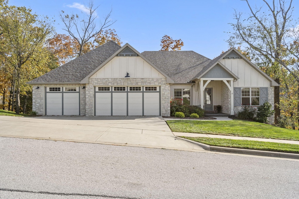
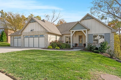
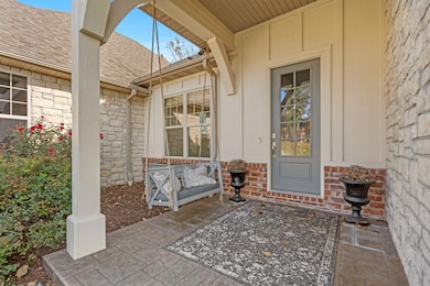
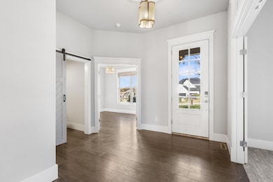
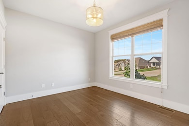
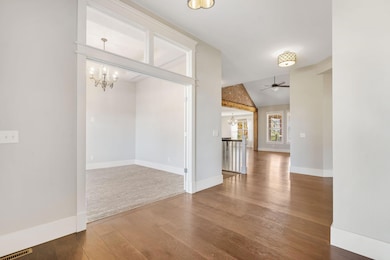
Stunning modern cottage style home in the prestigious Kelby Creek subdivision just south of Nixa! Set on a wooded lot and backing up to a beautiful community green space, this architecturally detailed home offers 6 bedrooms + office, 3.5 bathrooms, and the perfect blend of relaxation and entertainment spaces. The exterior's cottage curb appeal transitions to the interior, with architectural details like shiplap, brick and stone accents, wood beams, wide-plank hardwood floors, and tray ceilings. Main level provides an inviting open floorplan and rare layout with 4 bedrooms PLUS office, or 3 bedrooms with 2 offices! 2 bedrooms share a jack-and-jill bath. The spacious primary suite is a true sanctuary, featuring a gas fireplace, tray ceiling, walk-in shower, separate tub, and a generous walk-in closet. Laundry room conveniently connects to both the primary closet and the garage drop-zone area. The star of the main level is the incredible back deck living area, complete with cozy stone fireplace, shiplap ceiling, and ''treehouse'' views of the beautiful wooded community area behind. The oversized 3-car garage includes a convenient workspace area with cabinets and also one extra-deep stall. Next, head down to the walkout basement, an entertainer's dream boasting unique stained concrete floors, 12' ceilings, wood-burning fireplace, kitchenette, TV space, 2 more bedrooms, and 3rd full bathroom. But that's not all; this basement has an incredible amount of bonus space! There's a huge space perfect for home gym, theater room, or golf simulator! Also John Deere room with overhead door, storm/safe/gun room, and more additional storage spaces. With its thoughtfully designed layout, beautiful finishes, and ample space for both relaxation and entertainment, this home provides the perfect setting for creating lasting memories. Located just 3 minutes south of Nixa, Kelby Creek offers amazing community clubhouse, pool, walking trails around the ponds, and more!
Listing Agent
Keller Williams Brokerage Email: klrw369@kw.com License #2004014961 Listed on: 11/06/2025

Home Details
Home Type
- Single Family
Est. Annual Taxes
- $7,291
Year Built
- Built in 2016
Lot Details
- 0.63 Acre Lot
- Lot Dimensions are 187.1x145.9
- Few Trees
Home Design
- Brick Exterior Construction
- Wood Siding
- Stone
Interior Spaces
- 5,740 Sq Ft Home
- 1-Story Property
- Wet Bar
- Beamed Ceilings
- Tray Ceiling
- Vaulted Ceiling
- Multiple Fireplaces
- Wood Burning Fireplace
- Gas Fireplace
- Double Pane Windows
- Great Room
- Living Room with Fireplace
- Home Office
- Workshop
- Home Gym
Kitchen
- Built-In Electric Oven
- Gas Cooktop
- Microwave
- Dishwasher
- Kitchen Island
- Granite Countertops
- Disposal
Flooring
- Engineered Wood
- Painted or Stained Flooring
- Carpet
- Tile
Bedrooms and Bathrooms
- 6 Bedrooms
- Fireplace in Bedroom
- Walk-In Closet
- Walk-in Shower
Laundry
- Laundry Room
- Washer and Dryer Hookup
Finished Basement
- Walk-Out Basement
- Basement Fills Entire Space Under The House
- Fireplace in Basement
- Bedroom in Basement
Parking
- 3 Car Attached Garage
- Workshop in Garage
- Front Facing Garage
- Driveway
Outdoor Features
- Covered Patio or Porch
- Outdoor Fireplace
- Storm Cellar or Shelter
- Rain Gutters
Schools
- Nixa Elementary School
- Nixa High School
Utilities
- Forced Air Heating and Cooling System
- Heating System Uses Natural Gas
- High Speed Internet
- Cable TV Available
Listing and Financial Details
- Assessor Parcel Number 100735001005042000
Community Details
Overview
- Property has a Home Owners Association
- Association fees include clubhouse, common area maintenance, community center, exercise room, swimming pool, trash service, walking/bike trails
- Kelby Creek Subdivision
- On-Site Maintenance
Amenities
- Clubhouse
- Community Center
Recreation
- Fitness Center
- Community Pool
- Trails
Map
Home Values in the Area
Average Home Value in this Area
Tax History
| Year | Tax Paid | Tax Assessment Tax Assessment Total Assessment is a certain percentage of the fair market value that is determined by local assessors to be the total taxable value of land and additions on the property. | Land | Improvement |
|---|---|---|---|---|
| 2024 | $6,808 | $109,250 | -- | -- |
| 2023 | $6,808 | $109,250 | $0 | $0 |
| 2022 | $6,597 | $105,720 | $0 | $0 |
| 2021 | $6,601 | $105,720 | $0 | $0 |
| 2020 | $6,915 | $105,720 | $0 | $0 |
| 2019 | $6,915 | $105,720 | $0 | $0 |
| 2018 | $6,442 | $105,720 | $0 | $0 |
| 2017 | $6,442 | $105,720 | $0 | $0 |
| 2016 | $479 | $7,980 | $0 | $0 |
Property History
| Date | Event | Price | List to Sale | Price per Sq Ft |
|---|---|---|---|---|
| 11/06/2025 11/06/25 | For Sale | $850,000 | -- | $148 / Sq Ft |
Purchase History
| Date | Type | Sale Price | Title Company |
|---|---|---|---|
| Warranty Deed | -- | Hogan Land Title | |
| Warranty Deed | -- | Hogan Land Title Company | |
| Warranty Deed | -- | Great American Title | |
| Corporate Deed | -- | Great American Title |
Mortgage History
| Date | Status | Loan Amount | Loan Type |
|---|---|---|---|
| Previous Owner | $504,000 | New Conventional |
Source: Southern Missouri Regional MLS
MLS Number: 60309263
APN: 10-0.7-35-001-005-042.000
Disclaimer: Certain information contained herein is derived from information provided by parties other than Homes.com. All information provided is deemed reliable, but is not guaranteed to be accurate and should be independently verified.
![]() The data relating to real estate for sale on this web page comes in part from the Internet Data Exchange (IDX) of the Southern Missouri Regional MLS, LLC, Inc. Real estate listings held by Brokerage firms other than [Displaying Broker’s Name] are marked with the IDX logo and detailed information about them includes the name of the listing Brokers. The information being provided is for consumers’ personal, noncommercial use and may not be used for any purpose other than to identify prospective properties consumers may be interested in purchasing. The information being provided is not guaranteed, and all information should be verified by the consumer. Any representation that a web site contains all listings shall only mean that the website contains all listing available to the public through the IDX data feed. There may be other properties offered through a REALTOR® that have not been displayed on this site. © 2025 Southern Missouri Regional MLS, LLC. All rights reserved.
The data relating to real estate for sale on this web page comes in part from the Internet Data Exchange (IDX) of the Southern Missouri Regional MLS, LLC, Inc. Real estate listings held by Brokerage firms other than [Displaying Broker’s Name] are marked with the IDX logo and detailed information about them includes the name of the listing Brokers. The information being provided is for consumers’ personal, noncommercial use and may not be used for any purpose other than to identify prospective properties consumers may be interested in purchasing. The information being provided is not guaranteed, and all information should be verified by the consumer. Any representation that a web site contains all listings shall only mean that the website contains all listing available to the public through the IDX data feed. There may be other properties offered through a REALTOR® that have not been displayed on this site. © 2025 Southern Missouri Regional MLS, LLC. All rights reserved.
SOMO MLS respects the intellectual property rights of others and expects you to do the same. Per the DMCA, SOMO MLS will respond expeditiously to claims of copyright infringement on the Site if submitted to SOMO MLS' s Copyright Agent as described below. Upon receipt of a notice alleging copyright infringement, SOMO MLS will take whatever action it deems appropriate within its sole discretion, including removal of the allegedly infringing materials. If you believe that your intellectual property rights have been violated by SOMO MLS or by a third party who has uploaded materials to the Site, please provide the following information to SOMO MLS' s designated Copyright Agent listed below:
a. A description of the copyrighted work or other intellectual property that you claim has been infringed;
b. A description of where the material that you claim is infringing is located on the Site;
c. An address, telephone number, and e-mail address where SOMO MLS can contact you and, if different, an e-mail address where the alleged infringing party, if not SOMO MLS, can contact you;
d. A statement that you have a good-faith belief that the use is not authorized by the copyright owner or other intellectual property rights owner, by its agent, or by law;
e. A statement by you under penalty of perjury that the information in your notice is accurate and that you are the copyright or intellectual property owner or are authorized to act on the owner's behalf;
f. Your electronic or physical signature. SOMO MLS may request additional information before removing any allegedly infringing material.
In the event SOMO MLS removes the allegedly infringing materials, SOMO MLS will immediately notify the person responsible for posting such materials that SOMO MLS removed or disabled access to the materials. SOMO MLS may also provide the responsible person with your e-mail address so that the person may respond to your allegations. SOMO MLS reserves the right to terminate, limit or suspend any user's access to the Site in the event of repeated infringing activity. If you believe that a user of this Site is a repeat infringer, please follow the above instructions to contact SOMO MLS's Copyright Agent. Please include sufficient information to assist SOMO MLS in determining that the user repeatedly engaged in infringing activity. SOMO MLS registered a designated agent with the Copyright Office pursuant to 17 U.S.C. 512(c). SOMO MLS's designated Copyright Agent is: Jeff Kester 1310 Primrose, Springfield, MO 65804, Phone: 417-883-1226, Email: jeff@gsbor.com
- 347 W Monarchwood Dr
- 343 W Monarchwood Dr
- Lot 4 Kelby Creek Phase 4
- Lot 2 Kelby Creek Phase 4
- Lot 9 Kelby Creek Phase 4
- Lot 5 Kelby Creek Phase 4
- Lot 21 Kelby Creek Phase 4
- Lot 10 Kelby Creek Phase 4
- Lot 14 Kelby Creek Phase 4
- Lot 19 Kelby Creek Phase 4
- Lot 8 Kelby Creek Phase 4
- Lot 16 Kelby Creek Phase 4
- Lot 18 Kelby Creek Phase 4
- Lot 6 Kelby Creek Phase 4
- Lot 11 Kelby Creek Phase 4
- Lot 3 Kelby Creek Phase 4
- Lot 12 Kelby Creek Phase 4
- Lot 17 Kelby Creek Phase 4
- Lot 13 Kelby Creek Phase 4
- Lot 20 Kelby Creek Phase 4
- 102 E Mills Rd
- 836 S Black Sands Ave
- 829 S Parkside Cir
- 1309 W Eaglewood Dr
- 656 E Spring Valley Cir
- 120 N Peach Brook
- 1012-1014 N 26th St
- 106 E Greenbriar Dr
- 2145 W Bingham St
- 226-236 W Tracker Rd
- 2011 W Bingham St
- 2349 N 20th St
- 1424 S Solaria St
- 528 N Mary Lynn Ln
- 1000 W Snider St
- 801-817 W Warren Ave
- 706 W Snider St
- 4800 N 22nd St
- 2390 W Spring Dr
- 5612 N 17th St