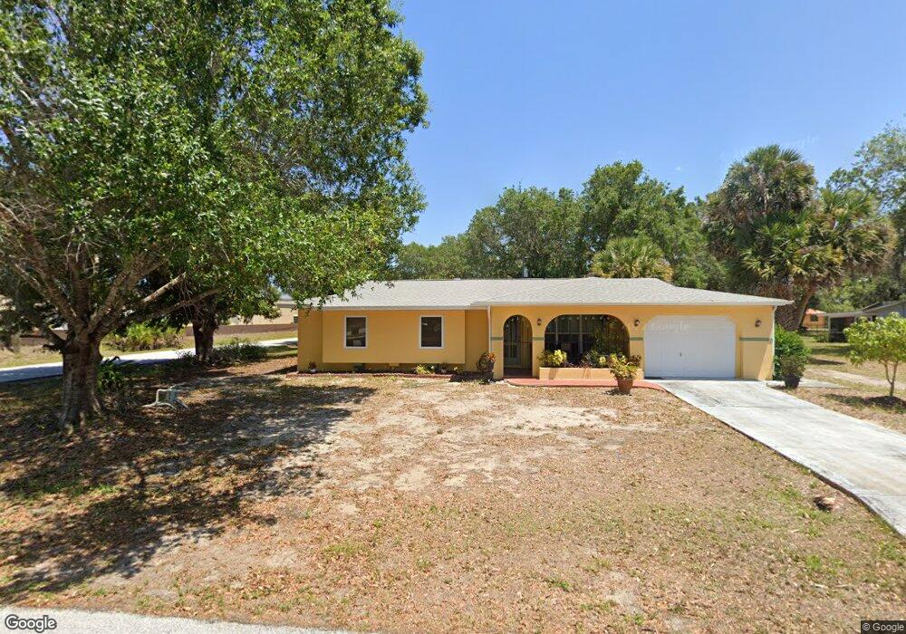
1295 Sheridan Dr NW Port Charlotte, FL 33948
Estimated Value: $258,640 - $282,000
3
Beds
2
Baths
1,309
Sq Ft
$205/Sq Ft
Est. Value
About This Home
This home is located at 1295 Sheridan Dr NW, Port Charlotte, FL 33948 and is currently estimated at $268,410, approximately $205 per square foot. 1295 Sheridan Dr NW is a home located in Charlotte County with nearby schools including Meadow Park Elementary School, Murdock Middle School, and Port Charlotte High School.
Ownership History
Date
Name
Owned For
Owner Type
Purchase Details
Closed on
Mar 15, 2022
Sold by
Paul Norma D
Bought by
Norma D Paul Trust
Current Estimated Value
Purchase Details
Closed on
Dec 5, 2005
Sold by
Green Lloyd
Bought by
Green Paul and Green Paul Norma
Purchase Details
Closed on
Nov 3, 2005
Sold by
Green Lloyd and Green Sandy J
Bought by
Green Lloyd
Purchase Details
Closed on
Aug 30, 2002
Sold by
Nelson Gary I
Bought by
Logan Sandy J
Home Financials for this Owner
Home Financials are based on the most recent Mortgage that was taken out on this home.
Original Mortgage
$107,865
Interest Rate
6.31%
Mortgage Type
Purchase Money Mortgage
Create a Home Valuation Report for This Property
The Home Valuation Report is an in-depth analysis detailing your home's value as well as a comparison with similar homes in the area
Home Values in the Area
Average Home Value in this Area
Purchase History
| Date | Buyer | Sale Price | Title Company |
|---|---|---|---|
| Norma D Paul Trust | -- | None Listed On Document | |
| Green Paul | -- | -- | |
| Green Lloyd | -- | -- | |
| Logan Sandy J | $119,900 | -- |
Source: Public Records
Mortgage History
| Date | Status | Borrower | Loan Amount |
|---|---|---|---|
| Previous Owner | Logan Sandy J | $107,865 |
Source: Public Records
Tax History Compared to Growth
Tax History
| Year | Tax Paid | Tax Assessment Tax Assessment Total Assessment is a certain percentage of the fair market value that is determined by local assessors to be the total taxable value of land and additions on the property. | Land | Improvement |
|---|---|---|---|---|
| 2025 | $4,421 | $243,276 | $16,575 | $226,701 |
| 2024 | $4,305 | $271,096 | $16,150 | $254,946 |
| 2023 | $4,305 | $198,109 | $0 | $0 |
| 2022 | $3,862 | $226,231 | $14,450 | $211,781 |
| 2021 | $3,395 | $163,726 | $5,015 | $158,711 |
| 2020 | $3,299 | $167,774 | $4,930 | $162,844 |
| 2019 | $3,081 | $160,284 | $6,011 | $154,273 |
| 2018 | $2,751 | $155,208 | $4,597 | $150,611 |
| 2017 | $2,538 | $134,645 | $4,597 | $130,048 |
| 2016 | $2,269 | $103,998 | $0 | $0 |
| 2015 | $2,167 | $94,544 | $0 | $0 |
| 2014 | $2,057 | $85,949 | $0 | $0 |
Source: Public Records
Map
Nearby Homes
- 1181 Seacrest Dr NW
- 19077 Cochran Blvd
- 1190 Seacrest Dr NW
- 1237 Pike Ave NW
- 2201 Hyatt Dr
- 1035 Red Bay Terrace NW
- 2193 Hyatt Dr
- 906 Bayard Terrace
- 948 Columbia Terrace
- 1073 Arden Terrace NW
- 2024 Pellam Blvd
- 2080 Pellam Blvd
- 2120 Broad Ranch Dr
- 2088 Pellam Blvd
- 931 Red Bay Terrace NW
- 1042 Malay Terrace NW
- 1030 Malay Terrace NW
- 1024 Malay Terrace NW
- 948 Andrews Ave NW
- 16054 Ivy Ridge Ct
- 19125 Baoy Ave
- 19179 Baoy Ave
- 1265 Sheridan Dr NW
- 1260 Sheridan Dr NW
- 1270 Sheridan Dr NW
- 1048 Vega Ave NW
- 19223 Baoy Ave
- 19171 Baoy Ave
- 1032 Vega Ave NW
- 19163 Baoy Ave
- 1271 Roswell Dr NW
- 1271 Drive NW
- 1261 Roswell Dr NW
- 1281 Roswell Dr NW
- 1235 Sheridan Dr NW
- 1240 Sheridan Dr NW
- 1016 Vega Ave NW
- 1251 Roswell Dr NW
- 19155 Baoy Ave