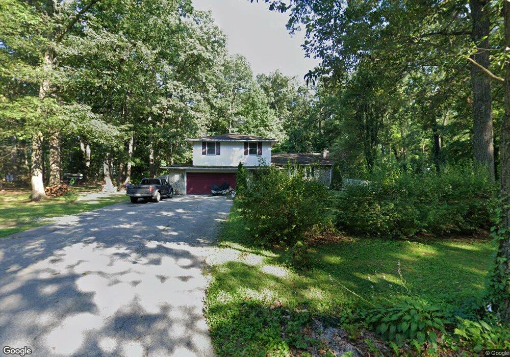
1296 Hoff Rd Hanover, PA 17331
Estimated Value: $324,410 - $412,000
4
Beds
2
Baths
2,285
Sq Ft
$162/Sq Ft
Est. Value
About This Home
This home is located at 1296 Hoff Rd, Hanover, PA 17331 and is currently estimated at $370,103, approximately $161 per square foot. 1296 Hoff Rd is a home located in York County with nearby schools including Spring Grove Area Middle School, Spring Grove Area High School, and Hope Christian School Of Hanover.
Ownership History
Date
Name
Owned For
Owner Type
Purchase Details
Closed on
Dec 6, 2006
Sold by
Shank Natalie R and Shank Ruth Celena
Bought by
Shank Natalie R
Current Estimated Value
Purchase Details
Closed on
Nov 10, 2005
Sold by
Strausbaugh Chrystelle L
Bought by
Shank Natalie R and Shank Ruth Celena
Home Financials for this Owner
Home Financials are based on the most recent Mortgage that was taken out on this home.
Original Mortgage
$160,000
Interest Rate
6.06%
Mortgage Type
Purchase Money Mortgage
Create a Home Valuation Report for This Property
The Home Valuation Report is an in-depth analysis detailing your home's value as well as a comparison with similar homes in the area
Purchase History
| Date | Buyer | Sale Price | Title Company |
|---|---|---|---|
| Shank Natalie R | $10,000 | None Available | |
| Shank Natalie R | $200,000 | None Available |
Source: Public Records
Mortgage History
| Date | Status | Borrower | Loan Amount |
|---|---|---|---|
| Previous Owner | Shank Natalie R | $40,000 | |
| Previous Owner | Shank Natalie R | $160,000 |
Source: Public Records
Tax History
| Year | Tax Paid | Tax Assessment Tax Assessment Total Assessment is a certain percentage of the fair market value that is determined by local assessors to be the total taxable value of land and additions on the property. | Land | Improvement |
|---|---|---|---|---|
| 2025 | $5,977 | $177,870 | $44,440 | $133,430 |
| 2024 | $5,913 | $177,870 | $44,440 | $133,430 |
| 2023 | $5,913 | $177,870 | $44,440 | $133,430 |
| 2022 | $5,913 | $177,870 | $44,440 | $133,430 |
| 2021 | $5,659 | $177,870 | $44,440 | $133,430 |
| 2020 | $5,659 | $177,870 | $44,440 | $133,430 |
| 2019 | $5,539 | $177,870 | $44,440 | $133,430 |
| 2018 | $5,465 | $177,870 | $44,440 | $133,430 |
| 2017 | $5,296 | $177,870 | $44,440 | $133,430 |
| 2016 | -- | $177,870 | $44,440 | $133,430 |
| 2015 | $3,618 | $177,870 | $44,440 | $133,430 |
| 2014 | $3,618 | $177,870 | $44,440 | $133,430 |
Source: Public Records
Map
Nearby Homes
- 1975 Smith Station Rd
- 70 Laurel Dr
- 1068 Grandview Rd
- 206 Hall Dr
- 116 Ruel Ave
- 29 Meadowview Dr
- 225 Bragg Cir
- 101 Overlook Dr
- 103 Overlook Dr
- 84 Lakeview Cir
- 1753 Black Rock Rd
- 150 Mumma Ave
- 517 Charles Ave
- 421 Charles Ave
- 819 8191/2 York St
- 48 Colonial Dr
- 44 Colonial Dr
- 320 Dubs Church Rd
- 139 Mussetta St
- 566 Baer Ave
Your Personal Tour Guide
Ask me questions while you tour the home.