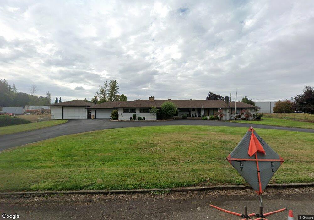
12966 S Highway 211 Molalla, OR 97038
Estimated Value: $920,000 - $1,219,874
3
Beds
2
Baths
4,117
Sq Ft
$267/Sq Ft
Est. Value
About This Home
This home is located at 12966 S Highway 211, Molalla, OR 97038 and is currently estimated at $1,099,291, approximately $267 per square foot. 12966 S Highway 211 is a home located in Clackamas County with nearby schools including Oregon Outreach - Molalla Pride.
Ownership History
Date
Name
Owned For
Owner Type
Purchase Details
Closed on
Mar 29, 2023
Sold by
Kathy D Schoenborn Revocable Living Trus
Bought by
Brinkman Jeffrey and Brinkman Lauri
Current Estimated Value
Purchase Details
Closed on
Aug 30, 2010
Sold by
Schoenborn Kathy D
Bought by
Schoenborn Kathy D and Kathy D Schoenborn Revocable Living Trus
Purchase Details
Closed on
Nov 7, 2002
Sold by
Schoenborn Rodney J
Bought by
Schoenborn Kathy D
Home Financials for this Owner
Home Financials are based on the most recent Mortgage that was taken out on this home.
Original Mortgage
$125,000
Interest Rate
5.95%
Create a Home Valuation Report for This Property
The Home Valuation Report is an in-depth analysis detailing your home's value as well as a comparison with similar homes in the area
Home Values in the Area
Average Home Value in this Area
Purchase History
| Date | Buyer | Sale Price | Title Company |
|---|---|---|---|
| Brinkman Jeffrey | $1,125,000 | Lawyers Title | |
| Schoenborn Kathy D | -- | None Available | |
| Schoenborn Kathy D | -- | First American Title Ins Co |
Source: Public Records
Mortgage History
| Date | Status | Borrower | Loan Amount |
|---|---|---|---|
| Previous Owner | Schoenborn Kathy D | $125,000 |
Source: Public Records
Tax History Compared to Growth
Tax History
| Year | Tax Paid | Tax Assessment Tax Assessment Total Assessment is a certain percentage of the fair market value that is determined by local assessors to be the total taxable value of land and additions on the property. | Land | Improvement |
|---|---|---|---|---|
| 2025 | $10,445 | $545,249 | -- | -- |
| 2024 | $10,096 | $529,368 | -- | -- |
| 2023 | $10,096 | $513,950 | $0 | $0 |
| 2022 | $8,325 | $498,981 | $0 | $0 |
| 2021 | $7,983 | $484,448 | $0 | $0 |
| 2020 | $7,760 | $470,338 | $0 | $0 |
| 2019 | $7,535 | $456,639 | $0 | $0 |
| 2018 | $7,324 | $443,339 | $0 | $0 |
| 2017 | $4,934 | $430,426 | $0 | $0 |
| 2016 | $4,628 | $417,889 | $0 | $0 |
| 2015 | $4,497 | $405,717 | $0 | $0 |
| 2014 | $4,350 | $393,900 | $0 | $0 |
Source: Public Records
Map
Nearby Homes
- 1406 W Main St
- 1014 S View Dr
- 902 S View Dr
- 900 Bear Creek Dr
- 1522 W Main St
- 340 Doug Fir Ln
- 31430 Oregon 213
- 0 W Main St Unit 765814723
- 850 N Valley Dr
- 33953 Oregon 213
- 701 Oriental Ct
- 714 Saint James Place
- 13434 S Lowe Rd
- 947 Meadowlark Place
- 843 Julie Ln
- 863 June Dr
- 569 June Dr
- 31514 S Bear Meadow Ct
- 30683 S Highway 213
- 13595 S Warrick Rd
- 12968 S Highway 211
- 12933 S Highway 211
- 13053 S Highway 211
- 13042 S Highway 211
- 12888 S Highway 211
- 0 Fountain Way Unit 2
- 12874 S Highway 211
- 1221 W Main St
- 1412 W Main St
- 1018 S View Dr
- 200 Forest Ln
- 1016 S View Dr
- 210 Forest Ln
- 220 Forest Ln
- 1012 S View Dr
- 1400 Fountain Way
- 1400 Fountain Way Unit 1
- 12860 S Highway 211
- 1418 W Main St
- 1010 S View Dr