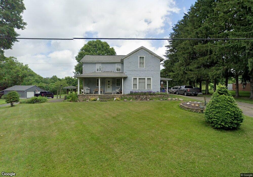
12972 Doylestown Rd Rittman, OH 44270
Estimated Value: $244,793 - $344,000
4
Beds
1
Bath
1,888
Sq Ft
$160/Sq Ft
Est. Value
About This Home
This home is located at 12972 Doylestown Rd, Rittman, OH 44270 and is currently estimated at $302,698, approximately $160 per square foot. 12972 Doylestown Rd is a home located in Wayne County with nearby schools including Rittman Elementary School, Rittman Middle School, and Rittman High School.
Ownership History
Date
Name
Owned For
Owner Type
Purchase Details
Closed on
Nov 25, 2024
Sold by
Robinson James and Robinson Diana
Bought by
Jacobs Grover and Robinson Sally J
Current Estimated Value
Purchase Details
Closed on
Mar 8, 2024
Sold by
Porter Susie and Porter Douglas
Bought by
Robinson Sally J and Robinson Sally
Purchase Details
Closed on
Feb 8, 2023
Sold by
Robinson Donna K
Bought by
Robinson Sally J
Purchase Details
Closed on
Jan 1, 1987
Bought by
Jacobs Sally and Ira Robins
Create a Home Valuation Report for This Property
The Home Valuation Report is an in-depth analysis detailing your home's value as well as a comparison with similar homes in the area
Home Values in the Area
Average Home Value in this Area
Purchase History
| Date | Buyer | Sale Price | Title Company |
|---|---|---|---|
| Jacobs Grover | $25,000 | None Listed On Document | |
| Jacobs Grover | $25,000 | None Listed On Document | |
| Robinson Sally J | -- | None Listed On Document | |
| Robinson Sally J | $300 | -- | |
| Robinson Sally J | $1,000 | None Listed On Document | |
| Jacobs Sally | -- | -- |
Source: Public Records
Tax History Compared to Growth
Tax History
| Year | Tax Paid | Tax Assessment Tax Assessment Total Assessment is a certain percentage of the fair market value that is determined by local assessors to be the total taxable value of land and additions on the property. | Land | Improvement |
|---|---|---|---|---|
| 2024 | $2,732 | $66,580 | $11,310 | $55,270 |
| 2023 | $2,732 | $66,580 | $11,310 | $55,270 |
| 2022 | $1,844 | $48,600 | $8,260 | $40,340 |
| 2021 | $1,872 | $48,600 | $8,260 | $40,340 |
| 2020 | $1,907 | $48,600 | $8,260 | $40,340 |
| 2019 | $1,266 | $33,820 | $7,360 | $26,460 |
| 2018 | $1,276 | $33,820 | $7,360 | $26,460 |
| 2017 | $1,269 | $33,820 | $7,360 | $26,460 |
| 2016 | $1,236 | $32,520 | $7,080 | $25,440 |
| 2015 | $1,192 | $32,520 | $7,080 | $25,440 |
| 2014 | $1,201 | $32,520 | $7,080 | $25,440 |
| 2013 | $1,198 | $32,560 | $7,080 | $25,480 |
Source: Public Records
Map
Nearby Homes
- 13270 Doylestown Rd
- 13293 Hatfield Rd
- 0 E Ohio Ave Unit 5118655
- 247 E Sunset Dr
- 22, 23 Gish Rd
- 200 Industrial St
- 258 Industrial St
- 245 Industrial St
- 970 Eastern Rd
- 42 N State St
- 41 E Ohio Ave
- 16 S State St
- 53 Grant St
- 27 S State St
- 13729 Galehouse Rd
- 56 Salt St
- 54 Salt St
- 176 N Main St
- 10 Windsor Mews
- 53 Thonen St
- 12942 Doylestown Rd
- 13008 Doylestown Rd
- 12971 Doylestown Rd
- 12933 Doylestown Rd
- 13039 Doylestown Rd
- 12873 Doylestown Rd
- 14544 Hatfield Rd
- 13091 Doylestown Rd
- 13100 Doylestown Rd
- 12814 Doylestown Rd
- 12807 Doylestown Rd
- 12901 Doylestown Rd
- 14604 Misty Ln
- 14138 Hatfield Rd
- 13136 Doylestown Rd
- 14601 Misty Ln
- 13159 Doylestown Rd
- 14442 Hatfield Rd
- 14372 Hatfield Rd
- 14328 Hatfield Rd