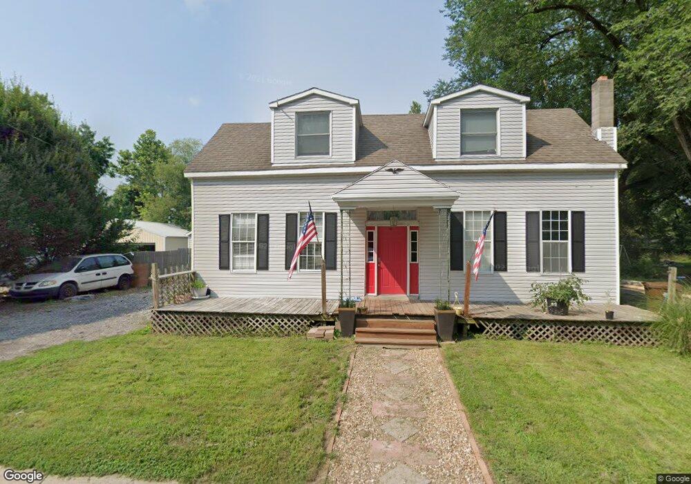
13 2nd St Saint Peters, MO 63376
Estimated Value: $261,000 - $283,726
3
Beds
2
Baths
2,219
Sq Ft
$123/Sq Ft
Est. Value
About This Home
This home is located at 13 2nd St, Saint Peters, MO 63376 and is currently estimated at $272,432, approximately $122 per square foot. 13 2nd St is a home located in St. Charles County with nearby schools including Lewis & Clark Elementary School, Dr. Bernard J. Dubray Middle School, and Fort Zumwalt East High School.
Ownership History
Date
Name
Owned For
Owner Type
Purchase Details
Closed on
Mar 28, 2014
Sold by
Bank Of America Na
Bought by
Lewis Jason B and Lewis Susan K
Current Estimated Value
Purchase Details
Closed on
Oct 9, 2009
Sold by
Taber Homer L and Taber Lynn
Bought by
Bobrinitz Michael J and Allen Ashley N
Home Financials for this Owner
Home Financials are based on the most recent Mortgage that was taken out on this home.
Original Mortgage
$133,536
Interest Rate
5.1%
Mortgage Type
FHA
Create a Home Valuation Report for This Property
The Home Valuation Report is an in-depth analysis detailing your home's value as well as a comparison with similar homes in the area
Home Values in the Area
Average Home Value in this Area
Purchase History
| Date | Buyer | Sale Price | Title Company |
|---|---|---|---|
| Lewis Jason B | $55,482 | None Available | |
| Bobrinitz Michael J | -- | Inv |
Source: Public Records
Mortgage History
| Date | Status | Borrower | Loan Amount |
|---|---|---|---|
| Previous Owner | Bobrinitz Michael J | $133,536 |
Source: Public Records
Tax History Compared to Growth
Tax History
| Year | Tax Paid | Tax Assessment Tax Assessment Total Assessment is a certain percentage of the fair market value that is determined by local assessors to be the total taxable value of land and additions on the property. | Land | Improvement |
|---|---|---|---|---|
| 2025 | $2,477 | $35,549 | -- | -- |
| 2023 | $2,475 | $34,537 | $0 | $0 |
| 2022 | $2,428 | $31,763 | $0 | $0 |
| 2021 | $2,424 | $31,763 | $0 | $0 |
| 2020 | $2,332 | $29,606 | $0 | $0 |
| 2019 | $2,327 | $29,606 | $0 | $0 |
| 2018 | $2,225 | $27,196 | $0 | $0 |
| 2017 | $2,215 | $27,196 | $0 | $0 |
| 2016 | $2,125 | $26,028 | $0 | $0 |
| 2015 | $1,990 | $26,028 | $0 | $0 |
| 2014 | $1,889 | $24,211 | $0 | $0 |
Source: Public Records
Map
Nearby Homes
- 412 Cardinal Commons Ct
- 125 S Gatty Dr
- 5 Saint Catherine Dr
- 114 Peruque Creek Manor
- 305 S Church St
- 312 Crown Colony Ct Unit F
- 24 Saint David Dr
- 36 Jamestown Dr
- 26 Steeplechase Dr
- 426 Cambridge Place
- 420 Cambridge Place Unit 2
- 406 S Church St Unit 128
- 1 Jamaica Dr
- 20 Churchill Downs Dr
- 410 Brown Rd
- 8 Cross Trail Ln
- 7418 Mexico Rd #100 Rd
- 16 Oxbow Rd
- 568 Prairie Home Dr
- 809 Estes Park Dr
- 3 2nd St
- 1 2nd St
- 7 2nd St
- 0 Carlyle-Qbv 2bblt
- 0 Byron-Queensbrookevillage 2bblt
- 0 2nd St Unit BDR
- 0 2nd St Unit 19001888
- 0TBB LOT 2 Torcy @ Belleau Creek
- 0 Susan~ Lot 24 1 & 24 2 Ave Unit 16023214
- 2 2nd St
- 0 Veterans Memorial Parkway 2 35
- 11 2nd St
- 10 2nd St
- 15 2nd St
- 14 2nd St
- 101 2nd St
- 17 Main St
- 102 2nd St
- 221 National St
- 1039 Main St