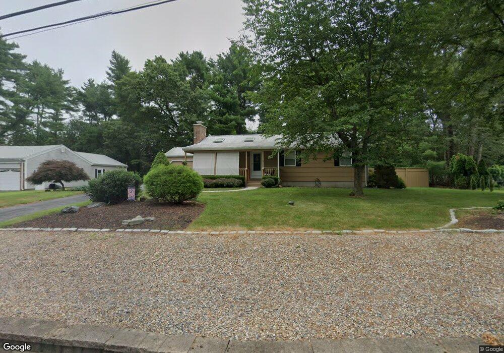
13 Allen St East Freetown, MA 02717
Estimated Value: $508,000 - $579,000
3
Beds
2
Baths
1,144
Sq Ft
$476/Sq Ft
Est. Value
About This Home
This home is located at 13 Allen St, East Freetown, MA 02717 and is currently estimated at $544,727, approximately $476 per square foot. 13 Allen St is a home located in Bristol County with nearby schools including Freetown Elementary School, George R Austin Intermediate School, and Freetown-Lakeville Middle School.
Ownership History
Date
Name
Owned For
Owner Type
Purchase Details
Closed on
Nov 10, 2011
Sold by
Looney Ft
Bought by
Looney Ft
Current Estimated Value
Purchase Details
Closed on
Nov 23, 2009
Sold by
Looney Peter and Looney Muriel B
Bought by
Looney Peter and Looney Muriel B
Purchase Details
Closed on
Oct 27, 1967
Bought by
Looney Ft
Create a Home Valuation Report for This Property
The Home Valuation Report is an in-depth analysis detailing your home's value as well as a comparison with similar homes in the area
Home Values in the Area
Average Home Value in this Area
Purchase History
| Date | Buyer | Sale Price | Title Company |
|---|---|---|---|
| Looney Ft | -- | -- | |
| Looney Peter | -- | -- | |
| Looney Ft | -- | -- |
Source: Public Records
Mortgage History
| Date | Status | Borrower | Loan Amount |
|---|---|---|---|
| Previous Owner | Looney Ft | $40,000 | |
| Previous Owner | Looney Ft | $80,000 |
Source: Public Records
Tax History Compared to Growth
Tax History
| Year | Tax Paid | Tax Assessment Tax Assessment Total Assessment is a certain percentage of the fair market value that is determined by local assessors to be the total taxable value of land and additions on the property. | Land | Improvement |
|---|---|---|---|---|
| 2025 | $4,332 | $437,100 | $173,700 | $263,400 |
| 2024 | $4,301 | $412,400 | $163,800 | $248,600 |
| 2023 | $4,202 | $392,300 | $147,500 | $244,800 |
| 2022 | $4,005 | $332,100 | $125,000 | $207,100 |
| 2021 | $2,434 | $302,400 | $113,600 | $188,800 |
| 2020 | $3,794 | $291,400 | $109,300 | $182,100 |
| 2019 | $3,586 | $272,700 | $104,100 | $168,600 |
| 2018 | $2,227 | $255,200 | $104,100 | $151,100 |
| 2017 | $3,306 | $248,200 | $104,100 | $144,100 |
| 2016 | $3,180 | $242,900 | $101,100 | $141,800 |
| 2015 | $3,099 | $240,200 | $101,100 | $139,100 |
| 2014 | $2,910 | $230,800 | $99,000 | $131,800 |
Source: Public Records
Map
Nearby Homes
- 3 Abraham Ave
- 247 Braley Hill Rd
- 269 Middleboro Rd
- 28 Cedar Hill Dr
- 9 Paul Ave
- 120 Hackett Ave
- 60 Lakeside Ave
- 714 Snipatuit Rd
- 21 Bennett Rd
- 168 Keene Rd
- 199 Quaker Ln
- 4597 Acushnet Ave
- 15 Morrison Way
- 562 North Ave
- 0 Keene Rd Unit 73459818
- 0 Costa Dr
- 319 Northwest St
- 353 Upland St
- 7 2nd Ave
- 14 2nd Ave