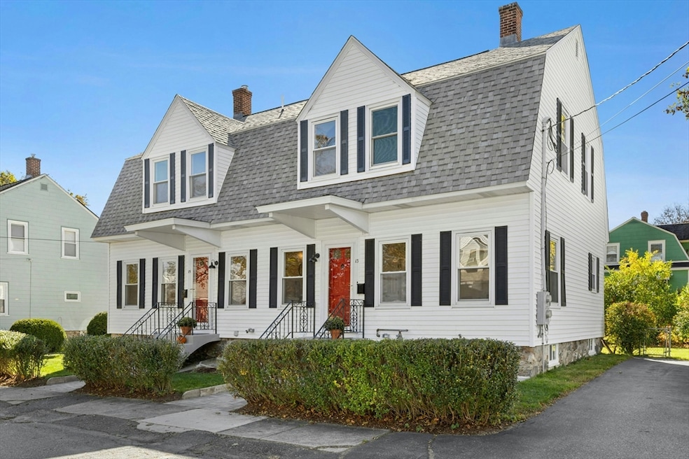

13 Arthur St Unit 15 Maynard, MA 01754
Highlights
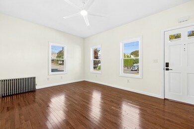
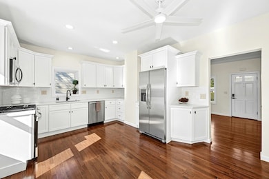
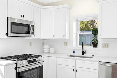
- Wood Flooring
- Stainless Steel Appliances
- Walk-In Closet
- Solid Surface Countertops
- Tandem Parking
- Bathtub with Shower
About This Home
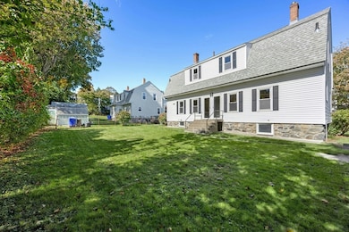
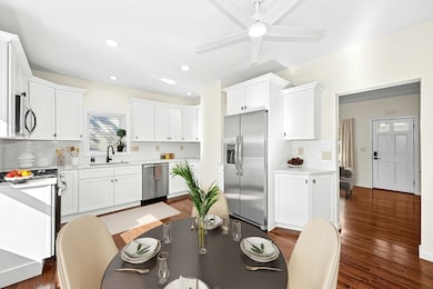
Here's your opportunity to own a completely renovated condominium and a piece of Maynard history. The home combines vintage charm with modern solutions. This striking 3 bedroom, 1.5 bath unit with high ceilings and hardwood floors is located in the desirable Presidential neighborhood convenient to Maynard center. Featuring a wonderful Cook’s kitchen with stainless appliances, tile backsplash, quartz counters and gas cooking. Also at this level, a spacious living room, and a half bath with laundry. Three bedrooms, and full bath upstairs help complete this must-see property. A large spacious backyard and parking for 2 cars. The unfinished basement, with utility sink & lav provides the perfect solution for storage space, exercise area, and workshop to mention a few.
Townhouse Details
Home Type
- Townhome
Year Built
- Built in 1915
HOA Fees
- $159 Monthly HOA Fees
Home Design
- Half Duplex
- Entry on the 1st floor
- Frame Construction
- Shingle Roof
Interior Spaces
- 1,144 Sq Ft Home
- 2-Story Property
- Ceiling Fan
- Light Fixtures
- Insulated Windows
- Window Screens
- Dining Area
- Center Hall
- Basement
Kitchen
- Range
- Microwave
- Dishwasher
- Stainless Steel Appliances
- Solid Surface Countertops
- Disposal
Flooring
- Wood
- Wall to Wall Carpet
- Ceramic Tile
Bedrooms and Bathrooms
- 3 Bedrooms
- Primary bedroom located on second floor
- Walk-In Closet
- Bathtub with Shower
- Linen Closet In Bathroom
Laundry
- Laundry on main level
- Washer and Electric Dryer Hookup
Home Security
Parking
- 2 Open Parking Spaces
- Tandem Parking
- Off-Street Parking
Schools
- Green Meadow Elementary School
- Fowler Middle School
- MHS High School
Utilities
- No Cooling
- 1 Heating Zone
- Heating System Uses Natural Gas
- Hot Water Heating System
Additional Features
- Rain Gutters
- 6,403 Sq Ft Lot
Listing and Financial Details
- Assessor Parcel Number 3636760
Community Details
Overview
- Association fees include insurance, reserve funds
- 2 Units
- 13 15 Arthur Street Condominium Community
Pet Policy
- Call for details about the types of pets allowed
Security
- Storm Doors
Map
Home Values in the Area
Average Home Value in this Area
Tax History
| Year | Tax Paid | Tax Assessment Tax Assessment Total Assessment is a certain percentage of the fair market value that is determined by local assessors to be the total taxable value of land and additions on the property. | Land | Improvement |
|---|---|---|---|---|
| 2025 | $8,689 | $487,300 | $267,700 | $219,600 |
| 2024 | $8,486 | $474,600 | $255,000 | $219,600 |
| 2023 | $8,514 | $448,800 | $242,800 | $206,000 |
| 2022 | $8,413 | $410,000 | $204,000 | $206,000 |
| 2021 | $8,066 | $400,300 | $204,000 | $196,300 |
| 2020 | $7,860 | $380,800 | $184,500 | $196,300 |
| 2019 | $7,225 | $343,400 | $176,300 | $167,100 |
| 2018 | $4,779 | $295,700 | $160,300 | $135,400 |
| 2017 | $6,508 | $295,700 | $160,300 | $135,400 |
| 2016 | $6,284 | $295,700 | $160,300 | $135,400 |
| 2015 | -- | $297,700 | $153,000 | $144,700 |
| 2014 | $6,743 | $302,500 | $148,100 | $154,400 |
Property History
| Date | Event | Price | List to Sale | Price per Sq Ft |
|---|---|---|---|---|
| 02/07/2026 02/07/26 | Pending | -- | -- | -- |
| 01/21/2026 01/21/26 | For Sale | $489,000 | 0.0% | $427 / Sq Ft |
| 01/20/2026 01/20/26 | Off Market | $489,000 | -- | -- |
| 01/09/2026 01/09/26 | For Sale | $489,000 | 0.0% | $427 / Sq Ft |
| 12/01/2025 12/01/25 | Pending | -- | -- | -- |
| 11/19/2025 11/19/25 | Price Changed | $489,000 | -2.0% | $427 / Sq Ft |
| 10/15/2025 10/15/25 | For Sale | $499,000 | -- | $436 / Sq Ft |
Purchase History
| Date | Type | Sale Price | Title Company |
|---|---|---|---|
| Quit Claim Deed | $610,000 | None Available | |
| Quit Claim Deed | $610,000 | None Available | |
| Deed | -- | -- | |
| Deed | -- | -- | |
| Deed | $280,000 | -- | |
| Deed | $240,000 | -- |
Mortgage History
| Date | Status | Loan Amount | Loan Type |
|---|---|---|---|
| Previous Owner | $224,000 | Purchase Money Mortgage | |
| Previous Owner | $210,000 | No Value Available | |
| Previous Owner | $190,000 | Purchase Money Mortgage |
Source: MLS Property Information Network (MLS PIN)
MLS Number: 73443898
APN: MAYN-000020-000000-000021
Disclaimer: Certain information contained herein is derived from information provided by parties other than Homes.com. All information provided is deemed reliable, but is not guaranteed to be accurate and should be independently verified.
![]() The property listing data and information, or the Images, set forth herein were provided to MLS Property Information Network, Inc. from third party sources, including sellers, lessors and public records, and were compiled by MLS Property Information Network, Inc. The property listing data and information, and the Images, are for the personal, non-commercial use of consumers having a good faith interest in purchasing or leasing listed properties of the type displayed to them and may not be used for any purpose other than to identify prospective properties which such consumers may have a good faith interest in purchasing or leasing. MLS Property Information Network, Inc. and its subscribers disclaim any and all representations and warranties as to the accuracy of the property listing data and information, or as to the accuracy of any of the Images, set forth herein.
The property listing data and information, or the Images, set forth herein were provided to MLS Property Information Network, Inc. from third party sources, including sellers, lessors and public records, and were compiled by MLS Property Information Network, Inc. The property listing data and information, and the Images, are for the personal, non-commercial use of consumers having a good faith interest in purchasing or leasing listed properties of the type displayed to them and may not be used for any purpose other than to identify prospective properties which such consumers may have a good faith interest in purchasing or leasing. MLS Property Information Network, Inc. and its subscribers disclaim any and all representations and warranties as to the accuracy of the property listing data and information, or as to the accuracy of any of the Images, set forth herein.
- 5 Hayes St Unit 5
- 31-33 Roosevelt St
- 22 Douglas Ave Unit 2
- 22 Douglas Ave Unit 1
- 38 Fairfield St
- 68 Powder Mill Rd
- 70 Powder Mill Rd
- 23 Deer Path Unit 5
- 12 Brown St
- 36 Brown St
- 41 Taylor Rd
- 10 Mill St Unit B
- 8 Snowberry Ln
- 57 Longfellow Rd
- 153 Summer St
- 63 Conant St
- 96 Forest Ridge Rd Unit 96
- 377 Willis Rd
- 1 Drummer Rd Unit A5
- 130 Parker St Unit J2

Ask me questions while you tour the home.