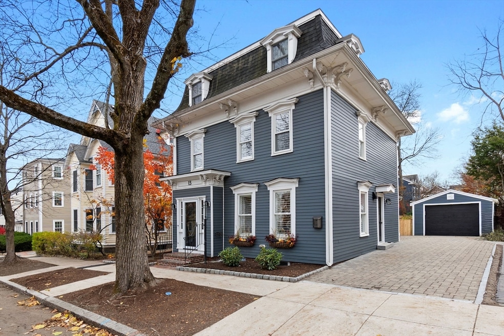
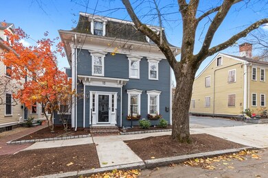

13 Broad St Newburyport, MA 01950
Estimated payment $9,346/month
Highlights
- Marina
- Golf Course Community
- Open Floorplan
- Newburyport High School Rated A-
- Medical Services
- 3-minute walk to Cashman Park
About This Home
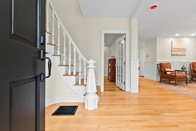
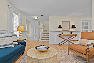
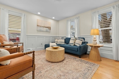
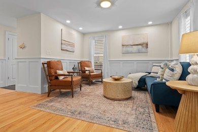
Welcome to 13 Broad Street, a beautifully updated Second Empire Mansard home in the heart of Newburyport. This property blends the charm of the era with the comfortable, modern updates today’s buyers appreciate. The main level features a freshly updated interior, including a stunning sunroom with a vaulted ceiling, radiant heated floors, and a cozy gas fireplace—an inviting space that opens directly to the private backyard. The updated kitchen, spacious living areas, and period millwork create a warm, welcoming flow throughout the home.Upstairs, the primary bedroom includes an en suite bath and walk-in closet, while additional well-proportioned bedrooms are served by a full bath with mosaic tile. The third floor offers an expansive family room, ideal for a media room, play space, or home office.A one-car garage, classic curb appeal, and a location close to downtown, parks, and the waterfront complete this special offering. A wonderful opportunity to enjoy Newburyport.

Home Details
Home Type
- Single Family
Est. Annual Taxes
- $11,164
Year Built
- Built in 1850
Lot Details
- 4,750 Sq Ft Lot
- Fenced Yard
- Property is zoned R3
Parking
- 1 Car Detached Garage
- Driveway
- Open Parking
Home Design
- Victorian Architecture
- Stone Foundation
- Frame Construction
- Shingle Roof
Interior Spaces
- 2,821 Sq Ft Home
- Open Floorplan
- Vaulted Ceiling
- Recessed Lighting
- 1 Fireplace
- Home Office
- Sun or Florida Room
- Walk-Out Basement
Kitchen
- Range
- Dishwasher
- Solid Surface Countertops
- Disposal
Flooring
- Wood
- Wall to Wall Carpet
- Ceramic Tile
Bedrooms and Bathrooms
- 3 Bedrooms
- Primary bedroom located on second floor
- Custom Closet System
- Bathtub with Shower
- Separate Shower
Laundry
- Laundry on upper level
- Gas Dryer Hookup
Outdoor Features
- Patio
Location
- Property is near public transit
- Property is near schools
Schools
- Bresnahan Elementary School
- Nock Middle School
- Newburyport High School
Utilities
- Ductless Heating Or Cooling System
- 5 Cooling Zones
- 7 Heating Zones
- Heating System Uses Natural Gas
- Radiant Heating System
- Baseboard Heating
- Gas Water Heater
Listing and Financial Details
- Assessor Parcel Number M:0054 B:0131 L:0000,2088229
Community Details
Overview
- No Home Owners Association
- Near Conservation Area
Amenities
- Medical Services
- Shops
- Coin Laundry
Recreation
- Marina
- Golf Course Community
- Tennis Courts
- Park
- Jogging Path
- Bike Trail
Map
Home Values in the Area
Average Home Value in this Area
Tax History
| Year | Tax Paid | Tax Assessment Tax Assessment Total Assessment is a certain percentage of the fair market value that is determined by local assessors to be the total taxable value of land and additions on the property. | Land | Improvement |
|---|---|---|---|---|
| 2025 | $11,164 | $1,165,300 | $415,100 | $750,200 |
| 2024 | $10,594 | $1,062,600 | $377,400 | $685,200 |
| 2023 | $10,884 | $1,013,400 | $328,200 | $685,200 |
| 2022 | $10,222 | $851,100 | $273,500 | $577,600 |
| 2021 | $9,475 | $749,600 | $248,600 | $501,000 |
| 2020 | $9,337 | $727,200 | $248,600 | $478,600 |
| 2019 | $9,055 | $692,300 | $248,600 | $443,700 |
| 2018 | $8,758 | $660,500 | $236,800 | $423,700 |
| 2017 | $8,564 | $636,700 | $225,500 | $411,200 |
| 2016 | $8,521 | $636,400 | $205,400 | $431,000 |
| 2015 | $8,036 | $602,400 | $205,400 | $397,000 |
Property History
| Date | Event | Price | List to Sale | Price per Sq Ft |
|---|---|---|---|---|
| 12/08/2025 12/08/25 | Pending | -- | -- | -- |
| 11/13/2025 11/13/25 | For Sale | $1,599,900 | -- | $567 / Sq Ft |
Purchase History
| Date | Type | Sale Price | Title Company |
|---|---|---|---|
| Deed | $1,250,000 | -- | |
| Quit Claim Deed | $1,200,000 | None Available | |
| Deed | $350,000 | -- |
Mortgage History
| Date | Status | Loan Amount | Loan Type |
|---|---|---|---|
| Open | $980,000 | Construction | |
| Previous Owner | $600,000 | Purchase Money Mortgage | |
| Previous Owner | $43,000 | No Value Available | |
| Previous Owner | $400,000 | No Value Available | |
| Previous Owner | $417,000 | No Value Available |
Source: MLS Property Information Network (MLS PIN)
MLS Number: 73454774
APN: NEWP-000054-000131
Disclaimer: Certain information contained herein is derived from information provided by parties other than Homes.com. All information provided is deemed reliable, but is not guaranteed to be accurate and should be independently verified.
![]() The property listing data and information, or the Images, set forth herein were provided to MLS Property Information Network, Inc. from third party sources, including sellers, lessors and public records, and were compiled by MLS Property Information Network, Inc. The property listing data and information, and the Images, are for the personal, non-commercial use of consumers having a good faith interest in purchasing or leasing listed properties of the type displayed to them and may not be used for any purpose other than to identify prospective properties which such consumers may have a good faith interest in purchasing or leasing. MLS Property Information Network, Inc. and its subscribers disclaim any and all representations and warranties as to the accuracy of the property listing data and information, or as to the accuracy of any of the Images, set forth herein.
The property listing data and information, or the Images, set forth herein were provided to MLS Property Information Network, Inc. from third party sources, including sellers, lessors and public records, and were compiled by MLS Property Information Network, Inc. The property listing data and information, and the Images, are for the personal, non-commercial use of consumers having a good faith interest in purchasing or leasing listed properties of the type displayed to them and may not be used for any purpose other than to identify prospective properties which such consumers may have a good faith interest in purchasing or leasing. MLS Property Information Network, Inc. and its subscribers disclaim any and all representations and warranties as to the accuracy of the property listing data and information, or as to the accuracy of any of the Images, set forth herein.
- 27 Warren St Unit 1
- 266 Merrimac St Unit F
- 288 Merrimac St
- 158 Merrimac St Unit 3
- 126 Merrimac St Unit 47
- 126 Merrimac St Unit 35
- 45 Boardman St Unit 1
- 41 Washington St Unit B
- 14 Dexter Ln Unit B
- 14 Dexter Ln Unit A
- 58 Merrimac St Unit 2-5
- 2 Court St Unit 4
- 175 Bridge Rd
- 110 Low St
- 138 Low St
- 10 10th St
- 1 Hill St
- 1 Hill St Unit 1
- 157 Bridge Rd
- 30-32 Water St Unit 4