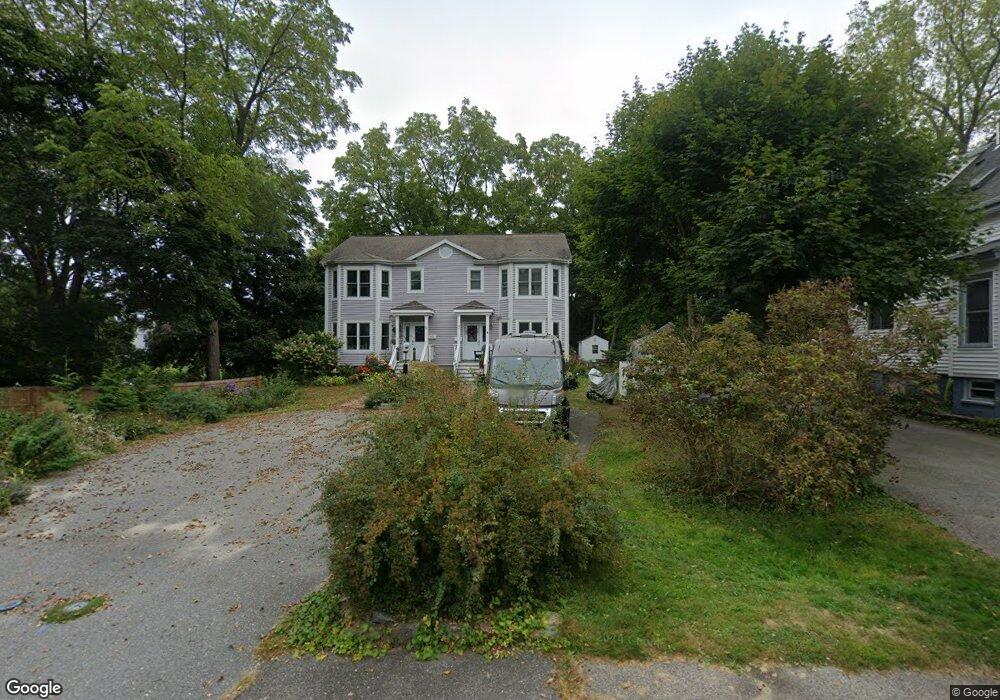
13 Bryant St Portland, ME 04103
Back Cove NeighborhoodEstimated Value: $550,000 - $627,000
3
Beds
3
Baths
1,444
Sq Ft
$397/Sq Ft
Est. Value
About This Home
This home is located at 13 Bryant St, Portland, ME 04103 and is currently estimated at $573,931, approximately $397 per square foot. 13 Bryant St is a home located in Cumberland County with nearby schools including Ocean Avenue Elementary School, Lyman Moore Middle School, and Baxter Academy for Tech & Sciences.
Ownership History
Date
Name
Owned For
Owner Type
Purchase Details
Closed on
Nov 13, 2023
Sold by
Rathbun Ellen L
Bought by
Ellen L Rathbun Lt and Rathbun
Current Estimated Value
Purchase Details
Closed on
Aug 24, 2015
Sold by
Foss Matthew A
Bought by
Rathbun Ellen L
Home Financials for this Owner
Home Financials are based on the most recent Mortgage that was taken out on this home.
Original Mortgage
$197,550
Interest Rate
4.07%
Mortgage Type
New Conventional
Purchase Details
Closed on
May 11, 2007
Sold by
Four Sills Llc
Bought by
Foss Matthew A
Home Financials for this Owner
Home Financials are based on the most recent Mortgage that was taken out on this home.
Original Mortgage
$184,500
Interest Rate
6.21%
Mortgage Type
Purchase Money Mortgage
Create a Home Valuation Report for This Property
The Home Valuation Report is an in-depth analysis detailing your home's value as well as a comparison with similar homes in the area
Home Values in the Area
Average Home Value in this Area
Purchase History
| Date | Buyer | Sale Price | Title Company |
|---|---|---|---|
| Ellen L Rathbun Lt | -- | None Available | |
| Ellen L Rathbun Lt | -- | None Available | |
| Rathbun Ellen L | -- | -- | |
| Rathbun Ellen L | -- | -- | |
| Foss Matthew A | -- | -- | |
| Foss Matthew A | -- | -- |
Source: Public Records
Mortgage History
| Date | Status | Borrower | Loan Amount |
|---|---|---|---|
| Previous Owner | Rathbun Ellen L | $197,550 | |
| Previous Owner | Foss Matthew A | $184,500 |
Source: Public Records
Tax History Compared to Growth
Tax History
| Year | Tax Paid | Tax Assessment Tax Assessment Total Assessment is a certain percentage of the fair market value that is determined by local assessors to be the total taxable value of land and additions on the property. | Land | Improvement |
|---|---|---|---|---|
| 2024 | $5,419 | $361,000 | $72,200 | $288,800 |
| 2023 | $5,202 | $361,000 | $72,200 | $288,800 |
| 2022 | $4,913 | $361,000 | $72,200 | $288,800 |
| 2021 | $4,689 | $361,000 | $72,200 | $288,800 |
| 2020 | $4,273 | $183,300 | $36,600 | $146,700 |
| 2019 | $4,273 | $183,300 | $36,600 | $146,700 |
| 2018 | $4,121 | $183,300 | $36,600 | $146,700 |
| 2017 | $3,968 | $183,300 | $36,600 | $146,700 |
| 2016 | $3,869 | $183,300 | $36,600 | $146,700 |
| 2015 | $3,781 | $183,300 | $36,600 | $146,700 |
| 2014 | $3,666 | $183,300 | $36,600 | $146,700 |
Source: Public Records
Map
Nearby Homes
- 42 Sawyer St
- 736 Forest Ave
- 25 Pleasant Ave
- 33 Mayland St
- 33 Bay View Dr
- 44 Hersey St
- 44 Pleasant Ave
- 89 Clinton St
- 45 George St
- 37 Wellington Rd
- 147 Pleasant Ave Unit 2
- 930 Forest Ave
- 48 Ashmont St
- 54 Read St
- 65 Mcauley Way Unit 506
- 14 Prospect St
- 37 Tremont St
- 75 Mcauley Way Unit 307
- 75 Mcauley Way Unit 206
- 75 Mcauley Way Unit 401