Estimated Value: $1,002,255 - $1,486,000
5
Beds
3
Baths
2,580
Sq Ft
$477/Sq Ft
Est. Value
About This Home
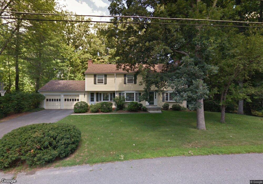
This home is located at 13 Captain Forbush Ln, Acton, MA 01720 and is currently estimated at $1,231,314, approximately $477 per square foot. 13 Captain Forbush Ln is a home located in Middlesex County with nearby schools including Acton-Boxborough Regional High School and The Imago School.
Ownership History
Date
Name
Owned For
Owner Type
Purchase Details
Closed on
Aug 18, 1993
Sold by
Vega John C and Vega Patricia A
Bought by
Gongwer R Scott and Gongwer Roberta K
Current Estimated Value
Home Financials for this Owner
Home Financials are based on the most recent Mortgage that was taken out on this home.
Original Mortgage
$230,000
Interest Rate
7.11%
Mortgage Type
Purchase Money Mortgage
Create a Home Valuation Report for This Property
The Home Valuation Report is an in-depth analysis detailing your home's value as well as a comparison with similar homes in the area
Home Values in the Area
Average Home Value in this Area
Purchase History
| Date | Buyer | Sale Price | Title Company |
|---|---|---|---|
| Gongwer R Scott | $321,000 | -- |
Source: Public Records
Mortgage History
| Date | Status | Borrower | Loan Amount |
|---|---|---|---|
| Open | Gongwer R Scott | $250,000 | |
| Closed | Gongwer R Scott | $25,000 | |
| Closed | Gongwer R Scott | $230,000 |
Source: Public Records
Tax History Compared to Growth
Tax History
| Year | Tax Paid | Tax Assessment Tax Assessment Total Assessment is a certain percentage of the fair market value that is determined by local assessors to be the total taxable value of land and additions on the property. | Land | Improvement |
|---|---|---|---|---|
| 2025 | $15,056 | $877,900 | $372,400 | $505,500 |
| 2024 | $14,099 | $845,800 | $372,400 | $473,400 |
| 2023 | $13,734 | $782,100 | $338,400 | $443,700 |
| 2022 | $13,214 | $679,400 | $294,000 | $385,400 |
| 2021 | $12,897 | $637,500 | $272,400 | $365,100 |
| 2020 | $12,167 | $632,400 | $272,400 | $360,000 |
| 2019 | $11,659 | $601,900 | $272,400 | $329,500 |
| 2018 | $11,465 | $591,600 | $272,400 | $319,200 |
| 2017 | $11,345 | $595,200 | $272,400 | $322,800 |
| 2016 | $11,140 | $579,300 | $272,400 | $306,900 |
| 2015 | $10,769 | $565,300 | $272,400 | $292,900 |
| 2014 | $10,445 | $537,000 | $272,400 | $264,600 |
Source: Public Records
Map
Nearby Homes
- 285 Central St Unit 285
- 9 Elm St Unit 1
- 5 Elm St Unit 1
- 31 Mohawk Dr
- 89 Windsor Ave
- 4,7,8 Crestwood Ln
- 4 Huron Rd
- 92 Willow St Unit 3
- 92 Willow St Unit 2
- 90 Willow St Unit 1
- 169 Main St
- 23 John Swift Rd
- 19 Railroad St Unit C2
- 129 Main St Unit 129
- 129 Main St
- 131 Main St
- 68 Macintosh Ln
- 5 Oakwood Rd
- 134 Russet Ln
- 8 Laurel Ct
- 11 Captain Forbush Ln
- 15 Captain Forbush Ln
- 24 Captain Browns Ln
- 14 Captain Forbush Ln
- 20 Captain Browns Ln
- 26 Captain Browns Ln
- 20 Captain Brown's Ln
- 16 Captain Forbush Ln
- 12 Captain Forbush Ln
- 17 Captain Forbush Ln
- 21 Joseph Reed Ln
- 9 Captain Forbush Ln
- 28 Captain Browns Ln
- 17 Joseph Reed Ln
- 23 Captain Browns Ln
- 10 Captain Forbush Ln
- 27 Captain Brown's Ln
- 25 Captain Browns Ln
- 29 Capt Brown's Ln
- 21 Captain Browns Ln