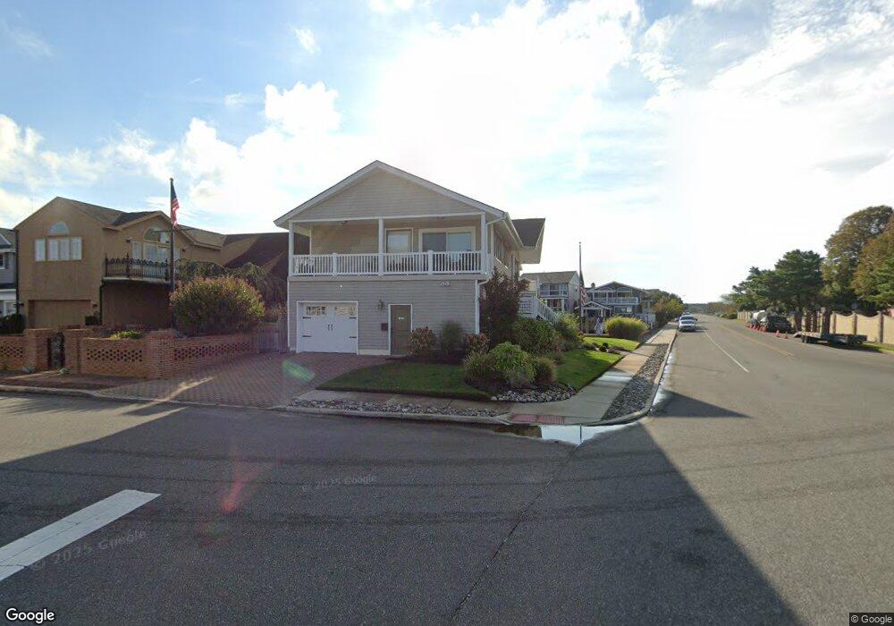
13 Coral Ln Ocean City, NJ 08226
Estimated Value: $2,020,000 - $2,733,000
--
Bed
--
Bath
2,829
Sq Ft
$825/Sq Ft
Est. Value
About This Home
This home is located at 13 Coral Ln, Ocean City, NJ 08226 and is currently estimated at $2,333,674, approximately $824 per square foot. 13 Coral Ln is a home located in Cape May County with nearby schools including Ocean City Primary School, Ocean City Intermediate School, and Ocean City High School.
Ownership History
Date
Name
Owned For
Owner Type
Purchase Details
Closed on
Jul 27, 2017
Sold by
Foglia Anthony R and Foglia Ellen A
Bought by
Iula Frank J and Iula Rosemary C
Current Estimated Value
Home Financials for this Owner
Home Financials are based on the most recent Mortgage that was taken out on this home.
Original Mortgage
$442,000
Outstanding Balance
$369,509
Interest Rate
4.03%
Mortgage Type
New Conventional
Estimated Equity
$1,964,165
Purchase Details
Closed on
Sep 15, 2011
Sold by
Albert Wayne and Albert Elissa
Bought by
Foglia Anthony R and Foglia Ellen A
Home Financials for this Owner
Home Financials are based on the most recent Mortgage that was taken out on this home.
Original Mortgage
$487,500
Interest Rate
4.38%
Mortgage Type
New Conventional
Purchase Details
Closed on
Nov 15, 1995
Sold by
Gross Larry
Bought by
Albert Wayne and Albert Elissa
Home Financials for this Owner
Home Financials are based on the most recent Mortgage that was taken out on this home.
Original Mortgage
$200,000
Interest Rate
7.53%
Create a Home Valuation Report for This Property
The Home Valuation Report is an in-depth analysis detailing your home's value as well as a comparison with similar homes in the area
Home Values in the Area
Average Home Value in this Area
Purchase History
| Date | Buyer | Sale Price | Title Company |
|---|---|---|---|
| Iula Frank J | $171,946 | Southern United Title Agency | |
| Foglia Anthony R | $975,000 | None Available | |
| Albert Wayne | $445,000 | -- |
Source: Public Records
Mortgage History
| Date | Status | Borrower | Loan Amount |
|---|---|---|---|
| Open | Iula Frank J | $442,000 | |
| Previous Owner | Foglia Anthony R | $487,500 | |
| Previous Owner | Albert Wayne | $200,000 |
Source: Public Records
Tax History Compared to Growth
Tax History
| Year | Tax Paid | Tax Assessment Tax Assessment Total Assessment is a certain percentage of the fair market value that is determined by local assessors to be the total taxable value of land and additions on the property. | Land | Improvement |
|---|---|---|---|---|
| 2025 | $10,826 | $964,900 | $722,500 | $242,400 |
| 2024 | $10,826 | $964,900 | $722,500 | $242,400 |
| 2023 | $10,334 | $964,900 | $722,500 | $242,400 |
| 2022 | $9,929 | $964,900 | $722,500 | $242,400 |
| 2021 | $9,697 | $964,900 | $722,500 | $242,400 |
| 2020 | $9,437 | $964,900 | $722,500 | $242,400 |
| 2019 | $9,331 | $964,900 | $722,500 | $242,400 |
| 2018 | $9,244 | $964,900 | $722,500 | $242,400 |
| 2017 | $9,099 | $964,900 | $722,500 | $242,400 |
| 2016 | $8,752 | $964,900 | $722,500 | $242,400 |
| 2015 | $8,636 | $964,900 | $722,500 | $242,400 |
| 2014 | $8,510 | $964,900 | $722,500 | $242,400 |
Source: Public Records
Map
Nearby Homes
- 9 Coral Ln
- 20 Gilbert Ln
- 2019 Glenwood Dr
- 100 Reef Dr
- 100 Reef Dr Unit 94
- 109 Easterly Dr Unit 130
- 4 Grenada Ln
- 71 Spruce Rd
- 126 Wahoo Dr
- 31 Spruce Rd
- 1909 Rosemar Ln
- 2104 Bay Ave
- 1906 Glenwood Dr
- 1904 Glenwood Dr
- 38 Arkansas Ave
- 2316 Simpson Ave Unit 18
- 1901 Glenwood Dr
- 6 Walnut Rd
- 2044 Haven Ave
- 2416 Haven Ave Unit 18