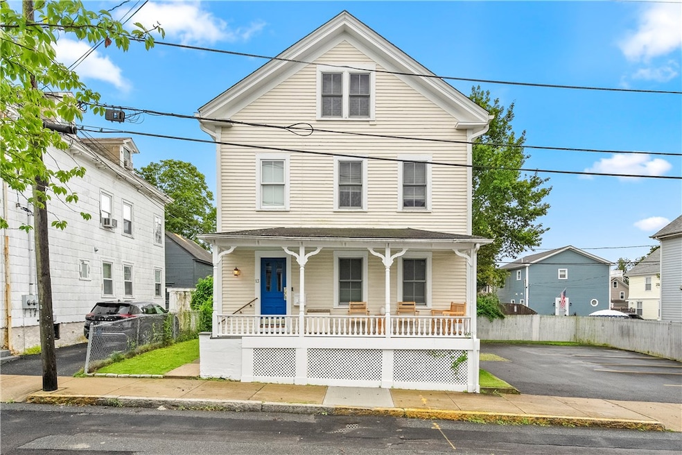
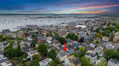

13 Dean Ave Newport, RI 02840
Fifth Ward NeighborhoodEstimated payment $8,642/month
Highlights
- Marina
- Deck
- Tennis Courts
- Golf Course Community
- Wood Flooring
- Walking Distance to Water
About This Home
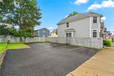
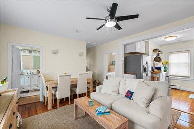
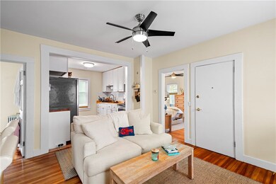
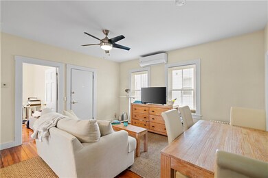
Newport is the place to be! Have your own place in the heart of yachting village with plenty of room to park your car and your tender. Walk to all the Newport happenings from your doorstep. Start your Newport story with this exceptional investment. Rent out the other two apts or have your in-laws or extended family join you next summer. Life is too short not to plan ahead for your summer fun. Sold furnished! Fully-restored 3 unit on oversized lot (25% building cov.) in the heart of Newport's Historic Yachting Village! Located steps to Thames Street and all Newport has to offer, this is a tremendous investment or owner occupant opportunity offering as high as a 8.2% Cap Rate--a stellar return for the area, and up to 6+ PARKING SPACES. The entire home has been renovated and restored from the roof to the Premium Andersen Replacement Windows with transferrable warranty. The home features three large units, (2) 2 BR/ 1.5 BA, and (1) 1BR/ 1 BA, all currently rented. Units feature hardwood flooring, premium bathrooms and kitchens completely updated and remodeled. Each unit has its own energy efficient ductless heating and cooling system, and is also connected to gas, water, sewer. The roof is young, and was stripped and replaced in 16 with transferrable warranties. Each unit comes w/ new dedicated Maytag washer/dryers.
Property Details
Home Type
- Multi-Family
Est. Annual Taxes
- $5,678
Year Built
- Built in 1900
Lot Details
- 4,095 Sq Ft Lot
- Fenced
Home Design
- Stone Foundation
- Wood Siding
- Clapboard
- Plaster
Interior Spaces
- 2,448 Sq Ft Home
- 3-Story Property
- Thermal Windows
- Storage Room
- Wood Flooring
Bedrooms and Bathrooms
- 5 Bedrooms
Laundry
- Laundry Room
- Dryer
- Washer
Unfinished Basement
- Basement Fills Entire Space Under The House
- Interior and Exterior Basement Entry
Parking
- 9 Parking Spaces
- No Garage
- Driveway
Eco-Friendly Details
- Energy-Efficient Windows
- Energy-Efficient HVAC
- Energy-Efficient Doors
Outdoor Features
- Walking Distance to Water
- Deck
Location
- Property near a hospital
Utilities
- Ductless Heating Or Cooling System
- Heating System Uses Gas
- Heat Pump System
- Water Heater
Listing and Financial Details
- Tax Lot 202
- Assessor Parcel Number 13DEANAVNEWP
Community Details
Overview
- 3 Units
- Yachting Village Subdivision
Amenities
- Shops
- Restaurant
- Public Transportation
Recreation
- Marina
- Golf Course Community
- Tennis Courts
- Recreation Facilities
Map
Home Values in the Area
Average Home Value in this Area
Tax History
| Year | Tax Paid | Tax Assessment Tax Assessment Total Assessment is a certain percentage of the fair market value that is determined by local assessors to be the total taxable value of land and additions on the property. | Land | Improvement |
|---|---|---|---|---|
| 2025 | $7,151 | $996,000 | $397,700 | $598,300 |
| 2024 | $5,674 | $814,100 | $397,700 | $416,400 |
| 2023 | $5,229 | $527,100 | $260,000 | $267,100 |
| 2022 | $5,065 | $527,100 | $260,000 | $267,100 |
| 2021 | $4,918 | $527,100 | $260,000 | $267,100 |
| 2020 | $4,258 | $414,200 | $221,700 | $192,500 |
| 2019 | $4,258 | $414,200 | $221,700 | $192,500 |
| 2018 | $4,138 | $414,200 | $221,700 | $192,500 |
| 2017 | $4,033 | $359,800 | $158,500 | $201,300 |
| 2016 | $3,933 | $359,800 | $158,500 | $201,300 |
| 2015 | $3,839 | $359,800 | $158,500 | $201,300 |
| 2014 | $3,589 | $297,600 | $134,800 | $162,800 |
Property History
| Date | Event | Price | List to Sale | Price per Sq Ft |
|---|---|---|---|---|
| 11/14/2025 11/14/25 | Price Changed | $1,549,999 | -3.1% | $633 / Sq Ft |
| 11/12/2025 11/12/25 | For Sale | $1,599,999 | 0.0% | $654 / Sq Ft |
| 11/11/2025 11/11/25 | Off Market | $1,599,999 | -- | -- |
| 11/09/2025 11/09/25 | Price Changed | $1,599,999 | -1.5% | $654 / Sq Ft |
| 10/29/2025 10/29/25 | Price Changed | $1,625,000 | -1.5% | $664 / Sq Ft |
| 10/25/2025 10/25/25 | Off Market | $1,650,000 | -- | -- |
| 10/24/2025 10/24/25 | Price Changed | $1,650,000 | 0.0% | $674 / Sq Ft |
| 10/24/2025 10/24/25 | For Sale | $1,650,000 | -1.5% | $674 / Sq Ft |
| 08/06/2025 08/06/25 | Price Changed | $1,675,000 | -5.7% | $684 / Sq Ft |
| 07/14/2025 07/14/25 | For Sale | $1,776,000 | -- | $725 / Sq Ft |
Purchase History
| Date | Type | Sale Price | Title Company |
|---|---|---|---|
| Deed | $310,000 | -- | |
| Deed | $310,000 | -- | |
| Warranty Deed | $135,000 | -- | |
| Warranty Deed | $135,000 | -- |
Mortgage History
| Date | Status | Loan Amount | Loan Type |
|---|---|---|---|
| Open | $245,100 | No Value Available | |
| Closed | $280,000 | No Value Available | |
| Closed | $280,000 | No Value Available |
Source: State-Wide MLS
MLS Number: 1389865
APN: NEWP-000035-000000-000202
Disclaimer: Certain information contained herein is derived from information provided by parties other than Homes.com. All information provided is deemed reliable, but is not guaranteed to be accurate and should be independently verified.
![]() IDX information is provided exclusively for personal, non-commercial use, and may not be used for any purpose other than to identify prospective properties consumers may be interested in purchasing. Information is deemed reliable but not guaranteed.
IDX information is provided exclusively for personal, non-commercial use, and may not be used for any purpose other than to identify prospective properties consumers may be interested in purchasing. Information is deemed reliable but not guaranteed.
Copyright © 2025 State-Wide MLS, Inc. All rights reserved.
- 29 Bacheller St
- 30 S Baptist St
- 6 Sharon Ct
- 604 Thames & 4 Dixon St
- 62 Dixon St
- 45 Hammond St Unit 2
- 28 Young St
- 364 Bellevue Ave Unit A1
- 364 Bellevue Ave Unit D7
- 24 Brown and Howard Wharf Unit 301
- 57 Clinton St Unit 57C
- 30 Brewer St Unit 3
- 39 Connection St
- 20 Berkeley Ave Unit 2
- 434 Bellevue Ave Unit 2B
- 91 Houston Ave
- 1 Harbor View Dr
- 13 Vaughan Ave
- 17 Meikle Ave Unit 19
- 0 Meikle Ave
- 21 Dean Ave Unit 2
- 23 Holland St Unit 1
- 20 Lee Ave Unit 2
- 27 Dean Ave Unit 1
- 46 Lee Ave Unit 1
- 13 Holland St Unit 1
- 461 Spring St
- 25 Dearborn St Unit 2
- 34 Bacheller St
- 7 Dearborn St Unit 2
- 7 Dearborn St Unit 1
- 580 Thames St Unit B2
- 468 Spring St Unit 2
- 7 Bacheller St
- 32 Mcallister St
- 426 Spring St Unit B101
- 492 Thames St Unit 4
- 28 Dixon St Unit 30
- 27 S Baptist St
- 594 Thames St
