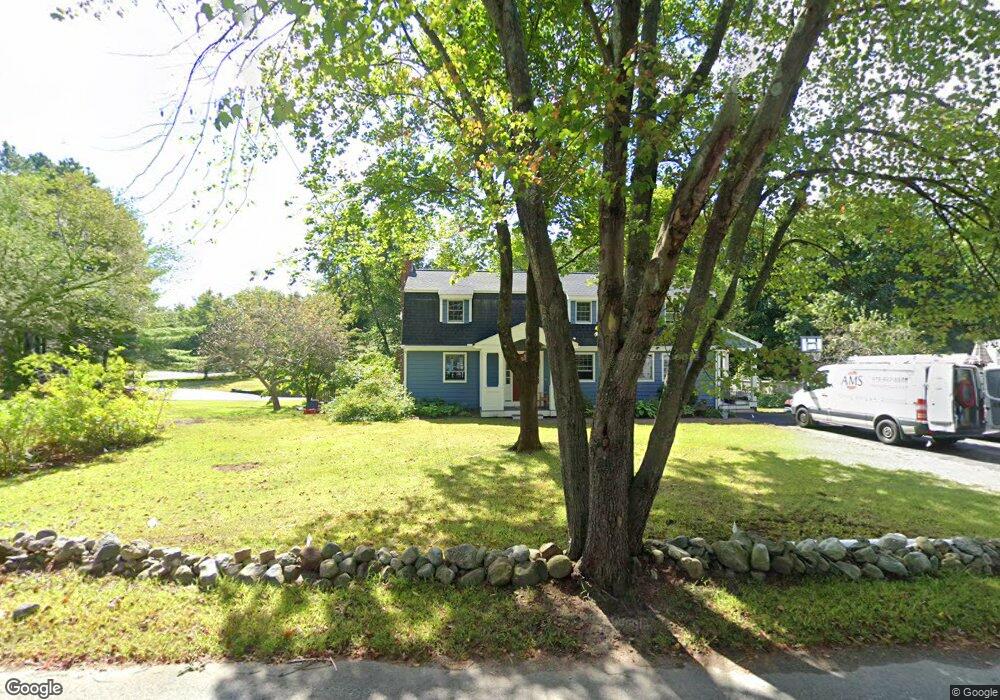
13 Dover St Concord, MA 01742
Estimated Value: $1,115,000 - $1,392,000
4
Beds
2
Baths
1,896
Sq Ft
$653/Sq Ft
Est. Value
About This Home
This home is located at 13 Dover St, Concord, MA 01742 and is currently estimated at $1,237,536, approximately $652 per square foot. 13 Dover St is a home located in Middlesex County with nearby schools including Willard School, Concord Middle School, and Concord Carlisle High School.
Ownership History
Date
Name
Owned For
Owner Type
Purchase Details
Closed on
Aug 30, 2005
Sold by
Ladd Barrett Lamothe and Ladd Gregory L
Bought by
Reed Pamela A and Reed Peter D
Current Estimated Value
Home Financials for this Owner
Home Financials are based on the most recent Mortgage that was taken out on this home.
Original Mortgage
$342,000
Interest Rate
5.68%
Mortgage Type
Purchase Money Mortgage
Purchase Details
Closed on
Jun 22, 2001
Sold by
Robbins John and Robbins Donna
Bought by
Ladd Gregory L and Ladd Barrett
Home Financials for this Owner
Home Financials are based on the most recent Mortgage that was taken out on this home.
Original Mortgage
$333,750
Interest Rate
7.09%
Mortgage Type
Purchase Money Mortgage
Create a Home Valuation Report for This Property
The Home Valuation Report is an in-depth analysis detailing your home's value as well as a comparison with similar homes in the area
Home Values in the Area
Average Home Value in this Area
Purchase History
| Date | Buyer | Sale Price | Title Company |
|---|---|---|---|
| Reed Pamela A | $639,000 | -- | |
| Ladd Gregory L | $445,000 | -- |
Source: Public Records
Mortgage History
| Date | Status | Borrower | Loan Amount |
|---|---|---|---|
| Open | Ladd Gregory L | $303,000 | |
| Closed | Reed Pamela A | $342,000 | |
| Previous Owner | Ladd Gregory L | $333,750 | |
| Closed | Ladd Gregory L | $66,750 |
Source: Public Records
Tax History
| Year | Tax Paid | Tax Assessment Tax Assessment Total Assessment is a certain percentage of the fair market value that is determined by local assessors to be the total taxable value of land and additions on the property. | Land | Improvement |
|---|---|---|---|---|
| 2025 | $136 | $1,026,200 | $470,400 | $555,800 |
| 2024 | $13,555 | $1,032,400 | $470,400 | $562,000 |
| 2023 | $12,744 | $983,300 | $448,000 | $535,300 |
| 2022 | $11,892 | $805,700 | $358,400 | $447,300 |
| 2021 | $11,442 | $777,300 | $358,400 | $418,900 |
| 2020 | $11,072 | $778,100 | $358,400 | $419,700 |
| 2019 | $10,445 | $736,100 | $347,900 | $388,200 |
| 2018 | $9,992 | $699,200 | $316,300 | $382,900 |
| 2017 | $9,427 | $670,000 | $322,800 | $347,200 |
| 2016 | $8,431 | $605,700 | $322,800 | $282,900 |
| 2015 | $7,688 | $538,000 | $279,000 | $259,000 |
Source: Public Records
Map
Nearby Homes
- 32 Bolton St
- 40 Rookery Ln Unit 5
- 72 Rookery Ln Unit 3
- 56 Seymour St
- 367 Powder Mill Rd
- 56 Rookery Ln Unit 4
- 108 Hawks Perch Unit 108
- 117 Cold Brook Dr Unit 7
- 401 Emery Ln Unit 304
- 850 Old Road to 9 Acre Corner
- 89 Mattison Dr
- 29 King Ln
- 132 Williams Rd
- 19 Skyview Ln
- 2 Skyview Ln
- 1201 Old Marlboro Rd
- 42 Dakin Rd
- 497 Old Road to 9 Acre Corner
- 1B Quaboag Valley Co-Op St
- Lot 5 Sailaway Ln
Your Personal Tour Guide
Ask me questions while you tour the home.