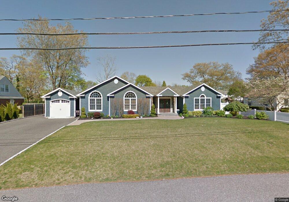
13 Edwards Ln E Blue Point, NY 11715
Estimated Value: $818,000 - $914,000
4
Beds
3
Baths
2,900
Sq Ft
$301/Sq Ft
Est. Value
About This Home
This home is located at 13 Edwards Ln E, Blue Point, NY 11715 and is currently estimated at $873,275, approximately $301 per square foot. 13 Edwards Ln E is a home located in Suffolk County with nearby schools including James Wilson Young Middle School, Bayport Blue Point High School, and Holy Angels Regional School.
Ownership History
Date
Name
Owned For
Owner Type
Purchase Details
Closed on
Apr 28, 2025
Sold by
Nicosia Linda L
Bought by
Linda Lee Nicoasia Irt and Nicosia
Current Estimated Value
Purchase Details
Closed on
Jan 10, 2025
Sold by
Nicosia John G and Nicosia Carol D
Bought by
Nicosia Linda L
Purchase Details
Closed on
May 16, 2016
Sold by
Garafola Joseph and Garafola Maria M
Bought by
Nicosia John G and Nicosia Carol D
Home Financials for this Owner
Home Financials are based on the most recent Mortgage that was taken out on this home.
Original Mortgage
$459,375
Interest Rate
3.59%
Mortgage Type
New Conventional
Purchase Details
Closed on
Aug 23, 2005
Sold by
Rohme Paul D
Bought by
Garafola Joseph
Create a Home Valuation Report for This Property
The Home Valuation Report is an in-depth analysis detailing your home's value as well as a comparison with similar homes in the area
Home Values in the Area
Average Home Value in this Area
Purchase History
| Date | Buyer | Sale Price | Title Company |
|---|---|---|---|
| Linda Lee Nicoasia Irt | -- | -- | |
| Linda Lee Nicoasia Irt | -- | -- | |
| Nicosia Linda L | $900,000 | Misc Company | |
| Nicosia Linda L | $900,000 | Misc Company | |
| Nicosia John G | $612,500 | Safe Harbor Title Agency Ltd | |
| Nicosia John G | $612,500 | Safe Harbor Title Agency Ltd | |
| Garafola Joseph | $479,900 | Albert Araneo | |
| Garafola Joseph | $479,900 | Albert Araneo |
Source: Public Records
Mortgage History
| Date | Status | Borrower | Loan Amount |
|---|---|---|---|
| Previous Owner | Nicosia John G | $459,375 |
Source: Public Records
Tax History
| Year | Tax Paid | Tax Assessment Tax Assessment Total Assessment is a certain percentage of the fair market value that is determined by local assessors to be the total taxable value of land and additions on the property. | Land | Improvement |
|---|---|---|---|---|
| 2022 | $14,834 | $3,560 | $300 | $3,260 |
| 2021 | $14,834 | $3,560 | $300 | $3,260 |
| 2020 | $15,375 | $3,560 | $300 | $3,260 |
| 2019 | $15,375 | $0 | $0 | $0 |
Source: Public Records
Map
Nearby Homes
- 85 Fairview Ave
- 94 Fairview Ave
- 20 Namkee Ln
- 4 Grandview Dr
- 103 Northwood Ct
- 249 Gerritsen Ave
- 6 Oyster Cove Ln
- 55 Oyster Cove Ln
- 36 Atlantic Ave
- 677 Montauk Hwy
- 18 Matilda Ct
- 339 Oakwood Ave
- 558 Gillette Ave
- 92 Oakwood Ave
- 84 Oakwood Ave
- 403 Middle Rd
- 115 Academy St
- 165 Edgewater Ave
- 485 3rd Ave
- 443 Renee Dr
Your Personal Tour Guide
Ask me questions while you tour the home.