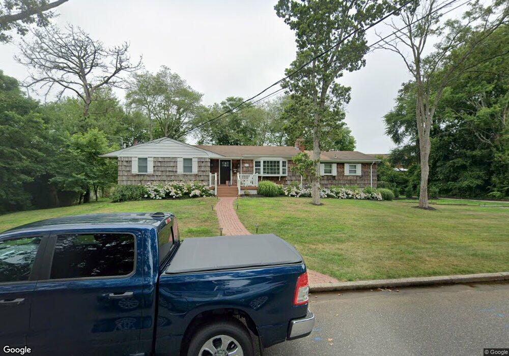
13 Lacy Ct Blue Point, NY 11715
Estimated Value: $710,444 - $990,000
4
Beds
3
Baths
--
Sq Ft
0.52
Acres
About This Home
This home is located at 13 Lacy Ct, Blue Point, NY 11715 and is currently estimated at $870,861. 13 Lacy Ct is a home located in Suffolk County with nearby schools including James Wilson Young Middle School, Bayport Blue Point High School, and Holy Angels Regional School.
Ownership History
Date
Name
Owned For
Owner Type
Purchase Details
Closed on
May 12, 2022
Sold by
Nigordo Michael and Nigordo Liat
Bought by
Nigordo Michael and Nigordo Liat
Current Estimated Value
Home Financials for this Owner
Home Financials are based on the most recent Mortgage that was taken out on this home.
Original Mortgage
$92,825
Interest Rate
5%
Mortgage Type
Stand Alone Refi Refinance Of Original Loan
Purchase Details
Closed on
May 5, 2014
Sold by
Tyson Thomas S and Ramirez Deborah D
Bought by
Ingordo Michael and Benedict Liat
Home Financials for this Owner
Home Financials are based on the most recent Mortgage that was taken out on this home.
Original Mortgage
$412,500
Interest Rate
4.33%
Mortgage Type
New Conventional
Purchase Details
Closed on
Aug 12, 2011
Sold by
Tyson Thomas S and Tyson Jeanmarie
Bought by
Tyson Thomas S and Ramirez Deborah D
Create a Home Valuation Report for This Property
The Home Valuation Report is an in-depth analysis detailing your home's value as well as a comparison with similar homes in the area
Home Values in the Area
Average Home Value in this Area
Purchase History
| Date | Buyer | Sale Price | Title Company |
|---|---|---|---|
| Nigordo Michael | -- | None Available | |
| Ingordo Michael | $435,000 | -- | |
| Tyson Thomas S | -- | -- |
Source: Public Records
Mortgage History
| Date | Status | Borrower | Loan Amount |
|---|---|---|---|
| Previous Owner | Nigordo Michael | $92,825 | |
| Previous Owner | Ingordo Michael | $412,500 |
Source: Public Records
Tax History Compared to Growth
Tax History
| Year | Tax Paid | Tax Assessment Tax Assessment Total Assessment is a certain percentage of the fair market value that is determined by local assessors to be the total taxable value of land and additions on the property. | Land | Improvement |
|---|---|---|---|---|
| 2024 | $16,251 | $3,375 | $200 | $3,175 |
| 2023 | $16,251 | $3,375 | $200 | $3,175 |
| 2022 | $15,680 | $3,375 | $200 | $3,175 |
| 2021 | $15,680 | $3,375 | $200 | $3,175 |
| 2020 | $13,283 | $3,375 | $200 | $3,175 |
| 2019 | $13,283 | $0 | $0 | $0 |
| 2018 | $15,482 | $4,100 | $200 | $3,900 |
| 2017 | $15,482 | $4,100 | $200 | $3,900 |
| 2016 | $15,654 | $4,100 | $200 | $3,900 |
| 2015 | -- | $4,100 | $200 | $3,900 |
| 2014 | -- | $4,100 | $200 | $3,900 |
Source: Public Records
Map
Nearby Homes
- 53 Oyster Cove Ln
- 25 Oyster Cove Ln
- 92 Park St
- 42 Corey Ave
- 19 Kuebler St
- 181 Blue Point Ave
- 63 Division Ave
- 146 Fairharbor Dr
- 151 Fairharbor Dr Unit 151
- 62 Hill St
- 159 Fairharbor Dr
- 8 Atlantic Ave
- 145 Fair Harbor Dr Unit 145
- 135 Fair Harbor Dr Unit 135
- 49 S Summit Ave
- 63 Fair Harbor Dr Unit 63
- 55 Fair Harbor Dr Unit 55
- 54 Fair Harbor Dr Unit 54
- 21 Fair Harbor Dr Unit 21
- 93 S Summit Ave