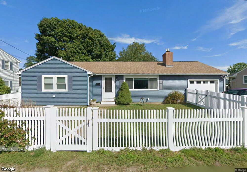
13 Linden Rd Gloucester, MA 01930
Riverview NeighborhoodEstimated Value: $744,000 - $858,000
3
Beds
2
Baths
1,289
Sq Ft
$613/Sq Ft
Est. Value
About This Home
This home is located at 13 Linden Rd, Gloucester, MA 01930 and is currently estimated at $789,851, approximately $612 per square foot. 13 Linden Rd is a home located in Essex County with nearby schools including Beeman Memorial, Ralph B O'maley Middle School, and Gloucester High School.
Ownership History
Date
Name
Owned For
Owner Type
Purchase Details
Closed on
Nov 8, 2024
Sold by
Curley Jon J and Curley Madith C
Bought by
Moose and Squirrel Jret
Current Estimated Value
Purchase Details
Closed on
Nov 13, 2009
Sold by
Curcuru Rosemary and Henry Linda A
Bought by
Curley Jon J
Home Financials for this Owner
Home Financials are based on the most recent Mortgage that was taken out on this home.
Original Mortgage
$267,200
Interest Rate
4.98%
Mortgage Type
Purchase Money Mortgage
Purchase Details
Closed on
Mar 4, 2003
Sold by
Parisi Grace and Curcuru Philip
Bought by
Curcuru Rosemary
Create a Home Valuation Report for This Property
The Home Valuation Report is an in-depth analysis detailing your home's value as well as a comparison with similar homes in the area
Home Values in the Area
Average Home Value in this Area
Purchase History
| Date | Buyer | Sale Price | Title Company |
|---|---|---|---|
| Moose | -- | None Available | |
| Moose | -- | None Available | |
| Curley Jon J | $334,000 | -- | |
| Curcuru Rosemary | $250,000 | -- | |
| Curley Jon J | $334,000 | -- | |
| Curcuru Rosemary | $250,000 | -- |
Source: Public Records
Mortgage History
| Date | Status | Borrower | Loan Amount |
|---|---|---|---|
| Previous Owner | Curcuru Rosemary | $256,500 | |
| Previous Owner | Curcuru Rosemary | $267,200 |
Source: Public Records
Tax History
| Year | Tax Paid | Tax Assessment Tax Assessment Total Assessment is a certain percentage of the fair market value that is determined by local assessors to be the total taxable value of land and additions on the property. | Land | Improvement |
|---|---|---|---|---|
| 2025 | $5,661 | $582,400 | $205,400 | $377,000 |
| 2024 | $5,515 | $566,800 | $195,600 | $371,200 |
| 2023 | $5,549 | $524,000 | $174,700 | $349,300 |
| 2022 | $5,206 | $443,800 | $148,500 | $295,300 |
| 2021 | $5,245 | $421,600 | $135,000 | $286,600 |
| 2020 | $5,013 | $406,600 | $135,000 | $271,600 |
| 2019 | $4,980 | $392,400 | $135,000 | $257,400 |
| 2018 | $4,924 | $380,800 | $135,000 | $245,800 |
| 2017 | $4,701 | $356,400 | $128,600 | $227,800 |
| 2016 | $4,437 | $326,000 | $129,000 | $197,000 |
| 2015 | $4,369 | $320,100 | $129,000 | $191,100 |
Source: Public Records
Map
Nearby Homes
- 13 Honeysuckle Rd
- 3 Deacon Farm Ln
- 31 Echo Ave
- 2 Breezy Point Rd
- 3 Rockland St
- 6 Monroe Ct
- 13 Mystic Ave
- 8 Mystic Ave
- 98 Maplewood Ave
- 167 Atlantic St
- 145 Essex Ave Unit 402
- 9 Cleveland Place
- 178 Atlantic St
- 15 Harvard St
- 12 Arthur St
- 5 Samoset Rd Unit B
- 24 Cobblestone Ln Unit 603
- 5 Lepage Ln
- 672 Washington St
- 40 Sargent St
Your Personal Tour Guide
Ask me questions while you tour the home.