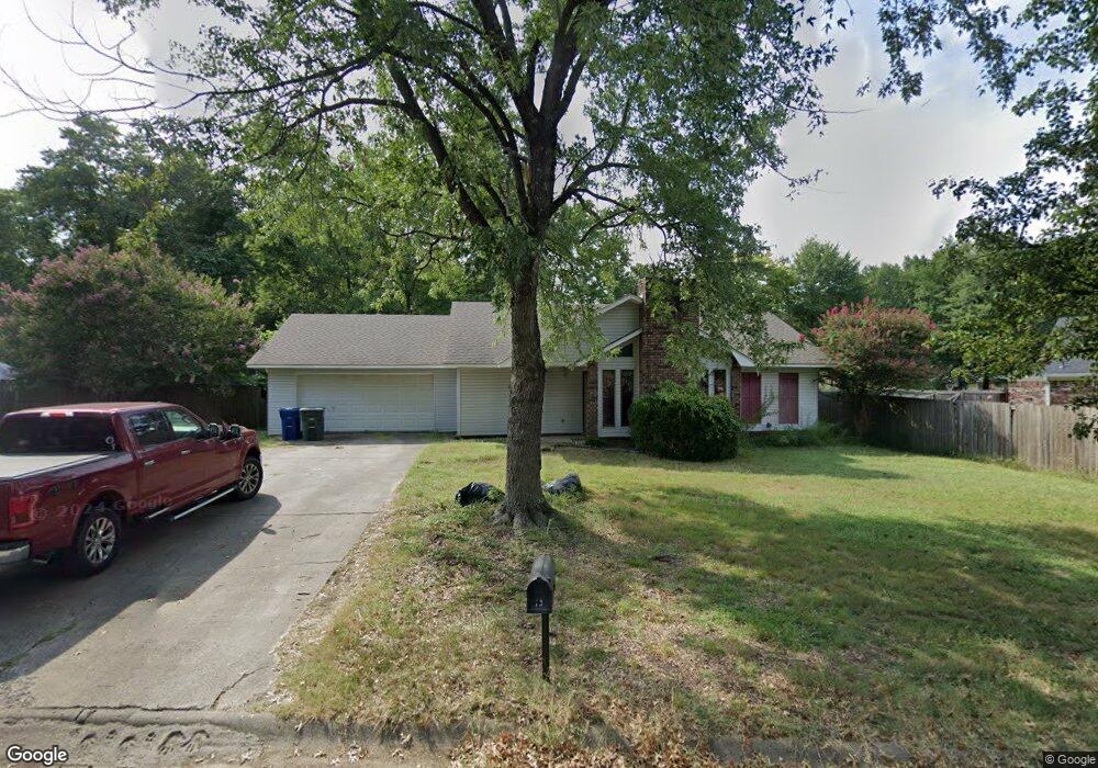
13 Mockingbird Ln Conway, AR 72032
East Conway NeighborhoodEstimated Value: $202,000 - $225,000
3
Beds
2
Baths
1,488
Sq Ft
$146/Sq Ft
Est. Value
About This Home
This home is located at 13 Mockingbird Ln, Conway, AR 72032 and is currently estimated at $216,703, approximately $145 per square foot. 13 Mockingbird Ln is a home located in Faulkner County with nearby schools including Preston & Florence Mattison Elementary School, Bob Courtway Middle School, and Conway Junior High School.
Ownership History
Date
Name
Owned For
Owner Type
Purchase Details
Closed on
Nov 21, 2016
Sold by
Dyer Kara and Dyer Jimmy
Bought by
Capps Joseph Alan and Capps Kristin
Current Estimated Value
Home Financials for this Owner
Home Financials are based on the most recent Mortgage that was taken out on this home.
Original Mortgage
$130,048
Outstanding Balance
$104,570
Interest Rate
3.47%
Mortgage Type
VA
Estimated Equity
$112,133
Purchase Details
Closed on
Mar 19, 2010
Sold by
Farris Sharon Y
Bought by
Propes Kara
Home Financials for this Owner
Home Financials are based on the most recent Mortgage that was taken out on this home.
Original Mortgage
$110,953
Interest Rate
4.87%
Mortgage Type
FHA
Purchase Details
Closed on
Aug 25, 2004
Bought by
Farris
Purchase Details
Closed on
Aug 19, 2004
Bought by
Farris
Create a Home Valuation Report for This Property
The Home Valuation Report is an in-depth analysis detailing your home's value as well as a comparison with similar homes in the area
Home Values in the Area
Average Home Value in this Area
Purchase History
| Date | Buyer | Sale Price | Title Company |
|---|---|---|---|
| Capps Joseph Alan | $127,000 | Conway Title Services & Escr | |
| Propes Kara | $113,000 | -- | |
| Farris | $93,000 | -- | |
| Farris | $93,000 | -- |
Source: Public Records
Mortgage History
| Date | Status | Borrower | Loan Amount |
|---|---|---|---|
| Open | Capps Joseph Alan | $130,048 | |
| Previous Owner | Propes Kara | $110,953 |
Source: Public Records
Tax History
| Year | Tax Paid | Tax Assessment Tax Assessment Total Assessment is a certain percentage of the fair market value that is determined by local assessors to be the total taxable value of land and additions on the property. | Land | Improvement |
|---|---|---|---|---|
| 2025 | $1,247 | $38,510 | $4,000 | $34,510 |
| 2024 | $1,190 | $38,510 | $4,000 | $34,510 |
| 2023 | $1,133 | $27,620 | $4,000 | $23,620 |
| 2022 | $709 | $27,620 | $4,000 | $23,620 |
| 2021 | $660 | $27,620 | $4,000 | $23,620 |
| 2020 | $611 | $19,490 | $3,200 | $16,290 |
| 2019 | $611 | $19,490 | $3,200 | $16,290 |
| 2018 | $636 | $19,490 | $3,200 | $16,290 |
| 2017 | $636 | $19,490 | $3,200 | $16,290 |
| 2016 | $636 | $19,490 | $3,200 | $16,290 |
| 2015 | $698 | $20,710 | $3,200 | $17,510 |
| 2014 | $698 | $20,710 | $3,200 | $17,510 |
Source: Public Records
Map
Nearby Homes
- 440 Bernard Dr
- 235 Great Falls
- 1906 Arrowhead Ln
- 2.2 Acres Amity Rd
- 360 Navaho Trail
- 000 E German Ln
- 2485 E Oak St
- 7 Ginger Dr
- 137 Union Rd
- 2510 E Oak St
- 2515 E Oak St
- 0 Hidden Valley Rd Unit 26009095
- 24 Lots Hays Add
- 82 Addi Ln
- 00 Caskay Dr
- 22 Southerland Rd
- 2100 Mary Alice Dr
- 00 Museum Rd
- 13 Martha Ln
- 575 5th Ave
Your Personal Tour Guide
Ask me questions while you tour the home.