Estimated Value: $781,637 - $904,000
4
Beds
2
Baths
1,930
Sq Ft
$446/Sq Ft
Est. Value
About This Home
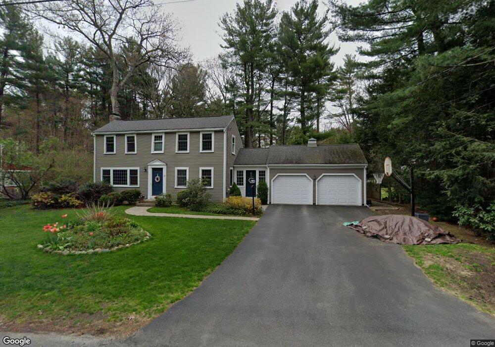
This home is located at 13 Mohegan Rd, Acton, MA 01720 and is currently estimated at $860,909, approximately $446 per square foot. 13 Mohegan Rd is a home located in Middlesex County with nearby schools including Acton-Boxborough Regional High School.
Ownership History
Date
Name
Owned For
Owner Type
Purchase Details
Closed on
May 28, 2020
Sold by
Kamieniecki Krzysztof and Kamieniecki Rebecca
Bought by
Tobey Amanda G and Collins Kathryn T
Current Estimated Value
Purchase Details
Closed on
Nov 14, 2005
Sold by
Boston David L and Boston Susan N
Bought by
Kamieniecki Krysztof E and Kamieniecki Rebecca
Home Financials for this Owner
Home Financials are based on the most recent Mortgage that was taken out on this home.
Original Mortgage
$353,000
Interest Rate
5.93%
Mortgage Type
Purchase Money Mortgage
Create a Home Valuation Report for This Property
The Home Valuation Report is an in-depth analysis detailing your home's value as well as a comparison with similar homes in the area
Home Values in the Area
Average Home Value in this Area
Purchase History
| Date | Buyer | Sale Price | Title Company |
|---|---|---|---|
| Tobey Amanda G | $609,000 | None Available | |
| Kamieniecki Krysztof E | $542,000 | -- |
Source: Public Records
Mortgage History
| Date | Status | Borrower | Loan Amount |
|---|---|---|---|
| Previous Owner | Kamieniecki Krysztof E | $353,000 |
Source: Public Records
Tax History
| Year | Tax Paid | Tax Assessment Tax Assessment Total Assessment is a certain percentage of the fair market value that is determined by local assessors to be the total taxable value of land and additions on the property. | Land | Improvement |
|---|---|---|---|---|
| 2025 | $12,381 | $721,900 | $312,600 | $409,300 |
| 2024 | $11,611 | $696,500 | $312,600 | $383,900 |
| 2023 | $11,303 | $643,700 | $284,100 | $359,600 |
| 2022 | $10,699 | $550,100 | $247,000 | $303,100 |
| 2021 | $10,400 | $514,100 | $228,700 | $285,400 |
| 2020 | $9,982 | $518,800 | $228,700 | $290,100 |
| 2019 | $9,454 | $488,100 | $228,700 | $259,400 |
| 2018 | $9,299 | $479,800 | $228,700 | $251,100 |
| 2017 | $9,067 | $475,700 | $228,700 | $247,000 |
| 2016 | $8,909 | $463,300 | $228,700 | $234,600 |
| 2015 | $8,593 | $451,100 | $228,700 | $222,400 |
| 2014 | $8,463 | $435,100 | $228,700 | $206,400 |
Source: Public Records
Map
Nearby Homes
- 5 Perkins Ln
- 60 Nashoba Rd
- 79 Charter Rd
- 20 Joseph Reed Ln
- 4 Littlefield Rd
- 235 Arlington St
- 631 Massachusetts Ave Unit 631
- 96 Newtown Rd
- 18 Hayward Rd
- 134 Russet Ln Unit 134
- 11 Braebrook
- 7 Kelley Rd
- 92 Willow St Unit 3
- 92 Willow St Unit 2
- 90 Willow St Unit 1
- 4 Omega Way
- 33 Meadowbrook Rd
- 46 Taylor Rd
- 184 Main St Unit 3
- 491 Main St
Your Personal Tour Guide
Ask me questions while you tour the home.