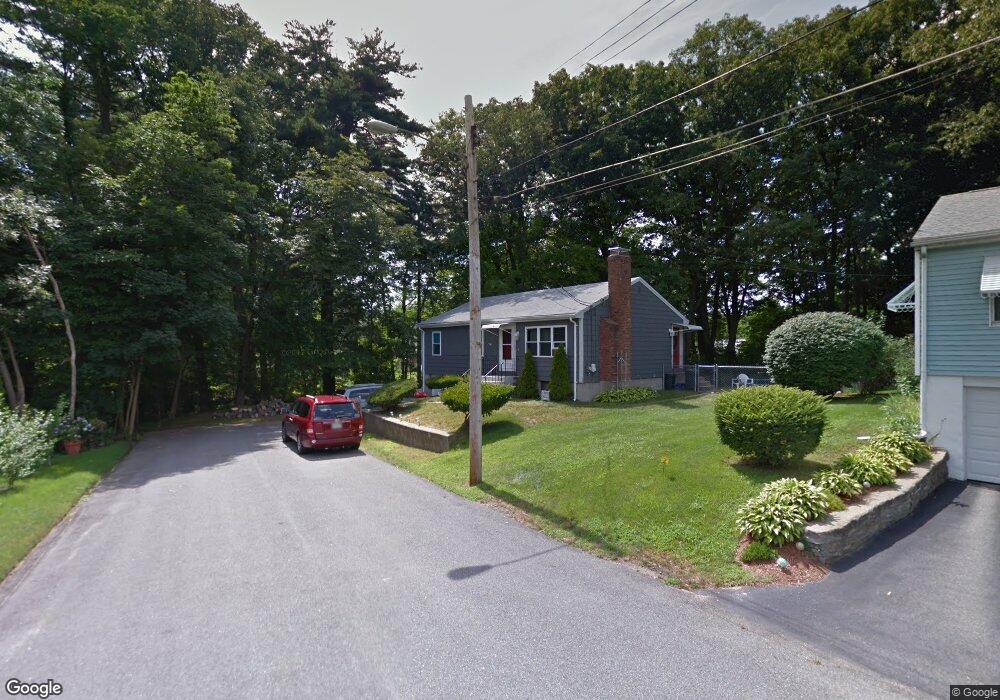
13 Mount Ida St Woburn, MA 01801
Cummingsville NeighborhoodEstimated Value: $627,116 - $751,000
3
Beds
1
Bath
988
Sq Ft
$699/Sq Ft
Est. Value
About This Home
This home is located at 13 Mount Ida St, Woburn, MA 01801 and is currently estimated at $690,529, approximately $698 per square foot. 13 Mount Ida St is a home located in Middlesex County with nearby schools including Hurld Elementary School, Daniel L. Joyce Middle School, and Woburn High School.
Ownership History
Date
Name
Owned For
Owner Type
Purchase Details
Closed on
Jul 30, 2004
Sold by
Marino Andrew and Marino Elizabth A
Bought by
Oleary Heather and Pacheco Michael
Current Estimated Value
Purchase Details
Closed on
Jan 30, 1998
Sold by
Hackett Diane E
Bought by
Marino Elizabeth A and Marino Andrew
Home Financials for this Owner
Home Financials are based on the most recent Mortgage that was taken out on this home.
Original Mortgage
$120,000
Interest Rate
7.02%
Mortgage Type
Purchase Money Mortgage
Purchase Details
Closed on
Jul 25, 1990
Sold by
Turbet Catherine B Est
Bought by
Hackett Diane E
Home Financials for this Owner
Home Financials are based on the most recent Mortgage that was taken out on this home.
Original Mortgage
$111,900
Interest Rate
10.01%
Mortgage Type
Purchase Money Mortgage
Create a Home Valuation Report for This Property
The Home Valuation Report is an in-depth analysis detailing your home's value as well as a comparison with similar homes in the area
Home Values in the Area
Average Home Value in this Area
Purchase History
| Date | Buyer | Sale Price | Title Company |
|---|---|---|---|
| Oleary Heather | $350,000 | -- | |
| Oleary Heather | $350,000 | -- | |
| Marino Elizabeth A | $160,400 | -- | |
| Hackett Diane E | $149,900 | -- | |
| Hackett Diane E | $149,900 | -- |
Source: Public Records
Mortgage History
| Date | Status | Borrower | Loan Amount |
|---|---|---|---|
| Previous Owner | Hackett Diane E | $120,000 | |
| Previous Owner | Hackett Diane E | $111,900 |
Source: Public Records
Tax History
| Year | Tax Paid | Tax Assessment Tax Assessment Total Assessment is a certain percentage of the fair market value that is determined by local assessors to be the total taxable value of land and additions on the property. | Land | Improvement |
|---|---|---|---|---|
| 2025 | $4,467 | $523,100 | $324,900 | $198,200 |
| 2024 | $4,090 | $507,400 | $309,400 | $198,000 |
| 2023 | $4,110 | $472,400 | $281,300 | $191,100 |
| 2022 | $3,977 | $425,800 | $244,600 | $181,200 |
| 2021 | $3,850 | $412,600 | $233,000 | $179,600 |
| 2020 | $3,639 | $390,500 | $233,000 | $157,500 |
| 2019 | $3,452 | $363,400 | $221,800 | $141,600 |
| 2018 | $3,323 | $336,000 | $203,500 | $132,500 |
| 2017 | $3,199 | $321,800 | $193,800 | $128,000 |
| 2016 | $3,046 | $303,100 | $181,200 | $121,900 |
| 2015 | $2,920 | $287,100 | $169,300 | $117,800 |
| 2014 | $2,801 | $268,300 | $169,300 | $99,000 |
Source: Public Records
Map
Nearby Homes
- 136 Bedford Rd
- 36 Cambridge Rd Unit 24
- 36 Cambridge Rd Unit 40
- 12 Cassidy Dr
- 19 Indian Hill Rd
- 16 Battlemarch Way
- 15 Crescent Rd
- 18 Beacon St Unit 18
- 31 Arlington Rd Unit 6
- 6 Randall Dr
- 80 N Warren St Unit 31
- 52 Pleasant St
- 15 Sturgis St
- 17 Wright St
- 148 Wyman St Unit 148
- 29 Overlook Ave
- 6 Porter St
- 7 Wainwright Rd Unit 15
- 230 Main St Unit 4
- 7 Prospect St