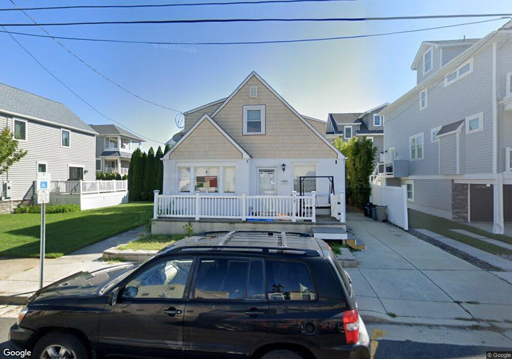
13 N Overbrook Ave Longport, NJ 08403
Estimated Value: $1,324,943 - $1,839,000
--
Bed
--
Bath
1,428
Sq Ft
$1,093/Sq Ft
Est. Value
About This Home
This home is located at 13 N Overbrook Ave, Longport, NJ 08403 and is currently estimated at $1,560,986, approximately $1,093 per square foot. 13 N Overbrook Ave is a home located in Atlantic County with nearby schools including Blessed Sacrament Regional School, St. James Elementary School, and Saint Joseph Regional School.
Ownership History
Date
Name
Owned For
Owner Type
Purchase Details
Closed on
Oct 7, 2021
Sold by
Dorothy Derose
Bought by
Fenimore Millie Ann and Derose Dorothy
Current Estimated Value
Purchase Details
Closed on
Aug 17, 2015
Sold by
Derose Dorothy and Marcasciano Joseph
Bought by
Derose Dorothy and Fenimore Millie Anne
Purchase Details
Closed on
Feb 4, 2007
Sold by
Marcasciano Joseph
Bought by
Dorothy Derose
Create a Home Valuation Report for This Property
The Home Valuation Report is an in-depth analysis detailing your home's value as well as a comparison with similar homes in the area
Home Values in the Area
Average Home Value in this Area
Purchase History
| Date | Buyer | Sale Price | Title Company |
|---|---|---|---|
| Fenimore Millie Ann | -- | Williams Robert W | |
| Derose Dorothy | -- | Attorney | |
| Dorothy Derose | -- | -- |
Source: Public Records
Tax History Compared to Growth
Tax History
| Year | Tax Paid | Tax Assessment Tax Assessment Total Assessment is a certain percentage of the fair market value that is determined by local assessors to be the total taxable value of land and additions on the property. | Land | Improvement |
|---|---|---|---|---|
| 2025 | $5,841 | $520,600 | $490,000 | $30,600 |
| 2024 | $5,841 | $520,600 | $490,000 | $30,600 |
| 2023 | $5,274 | $520,600 | $490,000 | $30,600 |
| 2022 | $5,274 | $520,600 | $490,000 | $30,600 |
| 2021 | $5,065 | $520,600 | $490,000 | $30,600 |
| 2020 | $5,133 | $520,600 | $490,000 | $30,600 |
| 2019 | $5,123 | $520,600 | $490,000 | $30,600 |
| 2018 | $5,123 | $520,600 | $490,000 | $30,600 |
| 2017 | $5,019 | $520,600 | $490,000 | $30,600 |
| 2016 | $4,821 | $520,600 | $490,000 | $30,600 |
| 2015 | $4,722 | $520,600 | $490,000 | $30,600 |
| 2014 | $4,675 | $520,600 | $490,000 | $30,600 |
Source: Public Records
Map
Nearby Homes
- 32 N Pelham Ave
- 32 N Manor Ave
- 24 N Evergreen Ave
- 3008 Ventnor Ave
- 2700 Atlantic Ave Unit 209
- 2700 Atlantic Ave Unit 419
- 2700 Atlantic Ave Unit 515
- 2404 Atlantic Ave
- 3216 Pacific Ave
- 3301 Atlantic Ave
- 212 N 33rd Ave
- 119 N 34th St
- 9801 Ventnor Ave Unit B-1
- 22 N Coolidge Ave
- 9704 Ventnor Ave Unit D
- 100 N Monroe #2 Ave
- 104 S Monroe Ave
- 7 S Monroe Ave
- 107 N Monroe Ave
- 9609 Pacific Ave Unit 5
- 9 N Overbrook Ave
- 10 N Pelham Ave
- 4 N Pelham Ave
- 17 N Overbrook Ave
- 18 N Pelham Ave
- 3 N Overbrook Ave
- 7 N 29th Ave
- 11 N 29th Ave
- 2906 Longport Dr
- 5 N 29th Ave
- 2908 Longport Dr
- 2 N Pelham Ave
- 15 N 29th Ave
- 1 N Overbrook Ave
- 3 N 29th Ave
- 2904 Longport Dr
- 5 N Pelham Ave
- 9 N Pelham Ave
- 2915 Ventnor Ave
- 15 N Pelham Ave