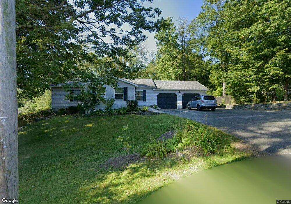
13 Opeechee St Lanesborough, MA 01237
Estimated Value: $368,000 - $472,000
3
Beds
2
Baths
1,835
Sq Ft
$229/Sq Ft
Est. Value
About This Home
This home is located at 13 Opeechee St, Lanesborough, MA 01237 and is currently estimated at $419,911, approximately $228 per square foot. 13 Opeechee St is a home located in Berkshire County with nearby schools including Lanesborough Elementary School, Lamar Co Voc Tech Center, and Mt. Greylock Regional High School.
Ownership History
Date
Name
Owned For
Owner Type
Purchase Details
Closed on
Oct 16, 1998
Sold by
Sinipoli Constr Co Inc
Bought by
Trybus Timothy J
Current Estimated Value
Create a Home Valuation Report for This Property
The Home Valuation Report is an in-depth analysis detailing your home's value as well as a comparison with similar homes in the area
Home Values in the Area
Average Home Value in this Area
Purchase History
| Date | Buyer | Sale Price | Title Company |
|---|---|---|---|
| Trybus Timothy J | $95,000 | -- |
Source: Public Records
Mortgage History
| Date | Status | Borrower | Loan Amount |
|---|---|---|---|
| Open | Trybus Timothy J | $187,325 | |
| Closed | Trybus Timothy J | $25,001 | |
| Closed | Trybus Timothy J | $120,000 |
Source: Public Records
Tax History Compared to Growth
Tax History
| Year | Tax Paid | Tax Assessment Tax Assessment Total Assessment is a certain percentage of the fair market value that is determined by local assessors to be the total taxable value of land and additions on the property. | Land | Improvement |
|---|---|---|---|---|
| 2025 | $5,825 | $348,200 | $81,600 | $266,600 |
| 2024 | $5,726 | $336,600 | $81,600 | $255,000 |
| 2023 | $5,425 | $307,000 | $74,200 | $232,800 |
| 2022 | $5,063 | $265,100 | $74,200 | $190,900 |
| 2021 | $4,890 | $241,100 | $64,400 | $176,700 |
| 2020 | $4,769 | $230,600 | $61,600 | $169,000 |
| 2019 | $4,291 | $233,400 | $61,600 | $171,800 |
| 2018 | $4,253 | $228,000 | $61,600 | $166,400 |
| 2017 | $4,244 | $226,900 | $63,000 | $163,900 |
| 2016 | $4,373 | $225,900 | $63,000 | $162,900 |
| 2015 | $4,269 | $224,900 | $63,000 | $161,900 |
Source: Public Records
Map
Nearby Homes
- 16 Opeechee St
- 0 Iroquois St
- 0 Umbagog St
- 2 Squanto Rd
- 0 Balance Rock Rd
- 22 Auburn St
- 0 Ocean St
- 15 Orlando Ave
- 211 Hancock Rd
- Lot 4 Ore Bed Rd
- 36 Beacon Ave
- 125 Hancock Rd
- 0 Beacon Ave
- 580 S Main St Unit 210
- 580 S Main St Unit 2-1
- 580 S Main St Unit Building 4 unit 2
- 144 Brombach St
- 10 Otis St
- 21 Sunset St
- 0 Miner Rd