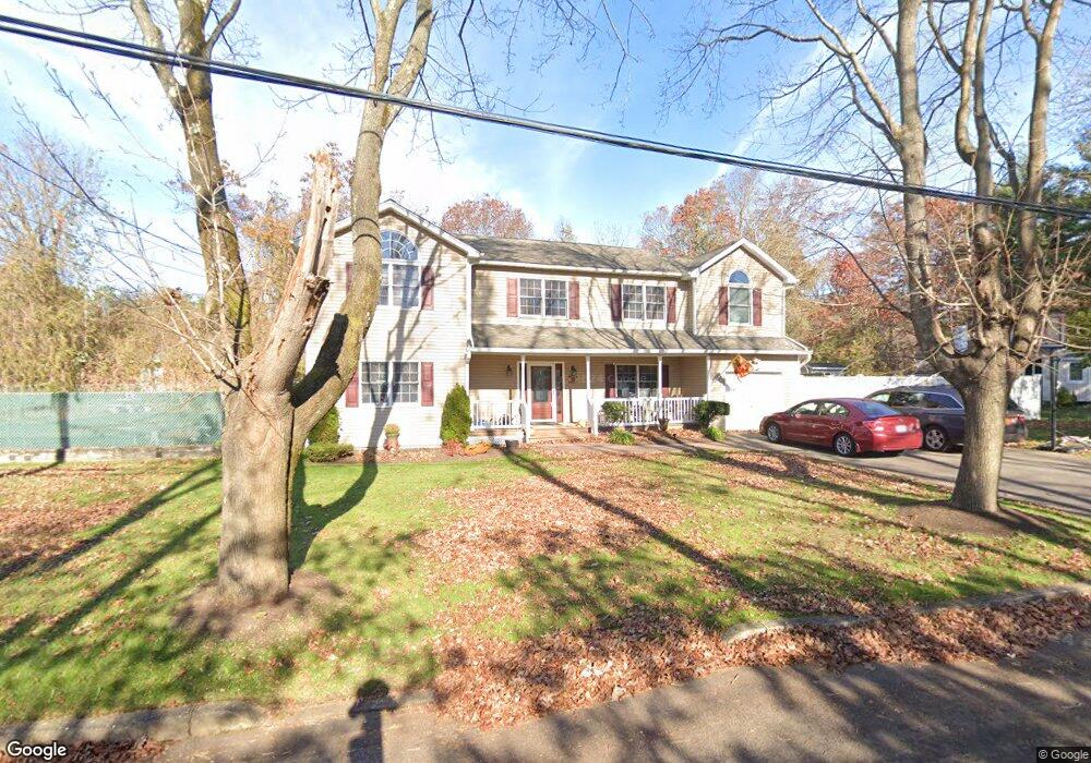
13 Pierson St Nesconset, NY 11767
Estimated Value: $822,000 - $913,000
4
Beds
3
Baths
2,255
Sq Ft
$379/Sq Ft
Est. Value
About This Home
This home is located at 13 Pierson St, Nesconset, NY 11767 and is currently estimated at $853,848, approximately $378 per square foot. 13 Pierson St is a home located in Suffolk County with nearby schools including Tackan Elementary School and St Patrick Elementary School.
Ownership History
Date
Name
Owned For
Owner Type
Purchase Details
Closed on
Mar 1, 2004
Sold by
Magistro Eugene R and Magistro Maria
Bought by
Rorick John F and Rorick Diane M
Current Estimated Value
Home Financials for this Owner
Home Financials are based on the most recent Mortgage that was taken out on this home.
Original Mortgage
$15,000
Outstanding Balance
$7,054
Interest Rate
5.65%
Mortgage Type
Credit Line Revolving
Estimated Equity
$846,794
Purchase Details
Closed on
Jan 7, 2003
Sold by
Zuppardo Ann
Bought by
Magistro Eugene R and Magistro Maria
Create a Home Valuation Report for This Property
The Home Valuation Report is an in-depth analysis detailing your home's value as well as a comparison with similar homes in the area
Home Values in the Area
Average Home Value in this Area
Purchase History
| Date | Buyer | Sale Price | Title Company |
|---|---|---|---|
| Rorick John F | $510,000 | -- | |
| Magistro Eugene R | $227,000 | Chicago Title Insurance Co |
Source: Public Records
Mortgage History
| Date | Status | Borrower | Loan Amount |
|---|---|---|---|
| Open | Rorick John F | $15,000 | |
| Open | Rorick John F | $250,000 |
Source: Public Records
Tax History Compared to Growth
Tax History
| Year | Tax Paid | Tax Assessment Tax Assessment Total Assessment is a certain percentage of the fair market value that is determined by local assessors to be the total taxable value of land and additions on the property. | Land | Improvement |
|---|---|---|---|---|
| 2024 | $16,880 | $6,520 | $80 | $6,440 |
| 2023 | $16,880 | $6,520 | $80 | $6,440 |
| 2022 | $12,043 | $6,520 | $80 | $6,440 |
| 2021 | $12,043 | $6,520 | $80 | $6,440 |
| 2020 | $16,099 | $6,520 | $80 | $6,440 |
| 2019 | $16,099 | $0 | $0 | $0 |
| 2018 | -- | $6,520 | $80 | $6,440 |
| 2017 | $12,325 | $5,775 | $80 | $5,695 |
| 2016 | $12,185 | $5,775 | $80 | $5,695 |
| 2015 | -- | $5,775 | $80 | $5,695 |
| 2014 | -- | $5,775 | $80 | $5,695 |
Source: Public Records
Map
Nearby Homes
- 19 Marion St
- 334 Lake Ave S
- 176 Southern Blvd
- 224 Southern Blvd
- 185 Southern Blvd
- 6 Hearthstone Ln
- 176 (Birmingham Plus Southern Blvd
- 6 Cleveland St
- 42 Maple Glen Ln
- 20 Lyda Dr
- 254 Gibbs Pond Rd
- 87 Mayfair Rd
- 310 Smithtown Blvd
- 477 Gibbs Pond Rd
- 177 San Juan Dr
- 115 Wood Ln
- 5 Roy Dr
- 87 Richmond Blvd Unit 2B
- 47 Jeremy Cir
- 64 Jeremy Cir
- 15 Pierson St
- 11 Pierson St
- 30 Brooks Ave
- 19 Pierson St
- 31 Lancaster Ave
- 9 Pierson St
- 31 Brooks Ave
- 29 Lancaster Ave
- 26 Brooks Ave
- 44 Roosevelt Ave
- 40 Roosevelt Ave
- 28 Lancaster Ave
- 24 Brooks Ave
- 24 Brooks Ave
- 24A Brooks Ave
- 38 Roosevelt Ave
- 27 Brooks Ave
- 27 Lancaster Ave
- 26 Lancaster Ave
- 8 Pierson St