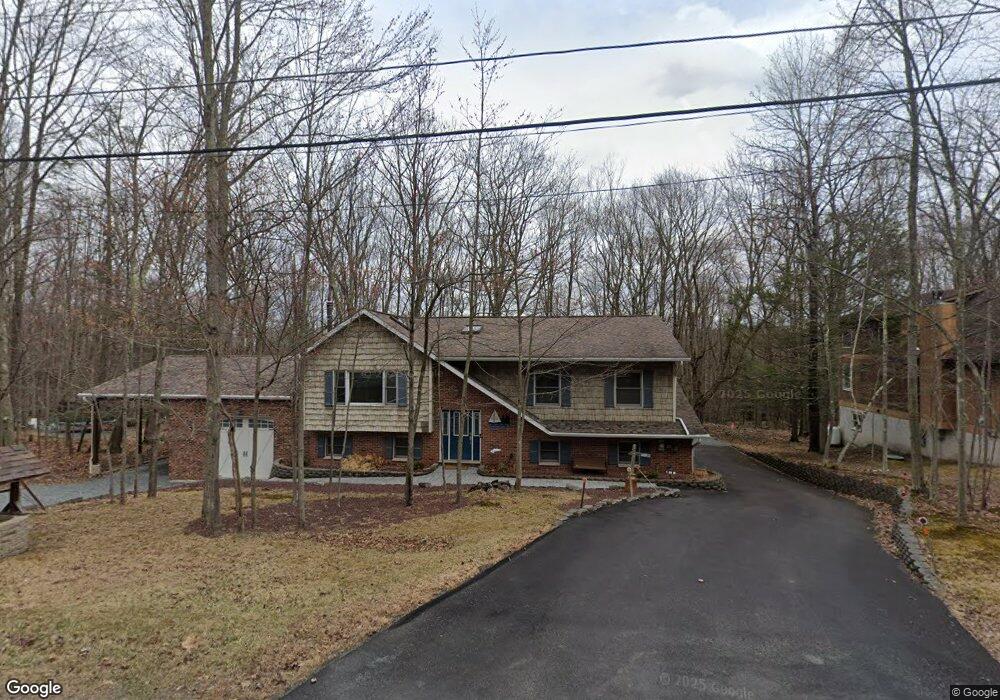
13 Silver Spring Rd Lake Ariel, PA 18436
Estimated Value: $306,000 - $361,000
3
Beds
2
Baths
1,652
Sq Ft
$208/Sq Ft
Est. Value
About This Home
This home is located at 13 Silver Spring Rd, Lake Ariel, PA 18436 and is currently estimated at $343,919, approximately $208 per square foot. 13 Silver Spring Rd is a home located in Wayne County with nearby schools including Western Wayne High School.
Ownership History
Date
Name
Owned For
Owner Type
Purchase Details
Closed on
Aug 26, 2014
Sold by
The Secretary Of Housing And Urban Devel
Bought by
Arnone Jennifer E and Arnone Steven J
Current Estimated Value
Home Financials for this Owner
Home Financials are based on the most recent Mortgage that was taken out on this home.
Original Mortgage
$97,600
Outstanding Balance
$74,664
Interest Rate
4.12%
Mortgage Type
New Conventional
Estimated Equity
$269,255
Purchase Details
Closed on
Apr 10, 2014
Sold by
Nationstar Mortgage Llc
Bought by
Secretary Of Hud
Purchase Details
Closed on
Feb 13, 2006
Sold by
Tri County Realty Agency Inc
Bought by
Tiniski Michael and Wodzenski Frances
Home Financials for this Owner
Home Financials are based on the most recent Mortgage that was taken out on this home.
Original Mortgage
$175,000
Interest Rate
7.37%
Mortgage Type
Assumption
Purchase Details
Closed on
Nov 7, 2005
Sold by
Tiniski Michael and Wodzenski Frances
Bought by
Tri County Realty Agency Inc
Create a Home Valuation Report for This Property
The Home Valuation Report is an in-depth analysis detailing your home's value as well as a comparison with similar homes in the area
Home Values in the Area
Average Home Value in this Area
Purchase History
| Date | Buyer | Sale Price | Title Company |
|---|---|---|---|
| Arnone Jennifer E | $122,500 | None Available | |
| Secretary Of Hud | -- | None Available | |
| Tiniski Michael | $197,116 | None Available | |
| Tri County Realty Agency Inc | $15,000 | None Available |
Source: Public Records
Mortgage History
| Date | Status | Borrower | Loan Amount |
|---|---|---|---|
| Open | Arnone Jennifer E | $97,600 | |
| Previous Owner | Tiniski Michael | $175,000 |
Source: Public Records
Tax History Compared to Growth
Tax History
| Year | Tax Paid | Tax Assessment Tax Assessment Total Assessment is a certain percentage of the fair market value that is determined by local assessors to be the total taxable value of land and additions on the property. | Land | Improvement |
|---|---|---|---|---|
| 2025 | $3,526 | $242,100 | $28,300 | $213,800 |
| 2024 | $3,366 | $242,100 | $28,300 | $213,800 |
| 2023 | $4,717 | $242,100 | $28,300 | $213,800 |
| 2022 | $3,239 | $149,400 | $15,000 | $134,400 |
| 2021 | $3,181 | $149,400 | $15,000 | $134,400 |
| 2020 | $3,172 | $149,400 | $15,000 | $134,400 |
| 2019 | $2,976 | $149,400 | $15,000 | $134,400 |
| 2018 | $2,918 | $149,400 | $15,000 | $134,400 |
| 2017 | $683 | $149,400 | $15,000 | $134,400 |
| 2016 | $2,758 | $149,400 | $15,000 | $134,400 |
| 2014 | -- | $149,400 | $15,000 | $134,400 |
Source: Public Records
Map
Nearby Homes
- 11 Meadow View Dr
- 1111 Advent Rd
- 921 Forest Ln
- 45 Forest Ln
- 29 Tanglewood Ln
- 58 Forest Ln
- 33 (2349) Crest View Rd
- 45 Crest View Rd
- 8 Brentwood Ct Unit Lot 1019
- 171 Ridgeview Dr
- 1412 Woodview Terrace Unit 56
- 139 Ridgeview Dr
- 1379 Woodview Terrace
- 68 Westwood Dr
- 34 Wildwood Ct
- 838 Wildwood Terrace
- 4 Avoy Heights Rd
- 1325 Lake Ariel Hwy
- 210 Deerfield Rd
- 297 E Shore Dr
- 10 Bluebird Dr
- 11 Bluebird Dr
- 24 Bluebird Dr
- 15 Bluebird Dr
- 22 Ln
- 2 Blue Bird Ln
- 49 Blue Bird Ln
- 21 Blue Bird Ln
- 1 Blue Bird Ln
- 111 Islandview Dr
- 95 Islandview Dr
- 93 Islandview Dr
- 116 Blue Bird Ln
- 120A Blue Bird Ln
- 1247 Advent Rd
- 119 Islandview Dr
- 119 Island View Dr
- 119 Island View Dr
- 22 Blue Bird Ln
- 118 Blue Bird Ln