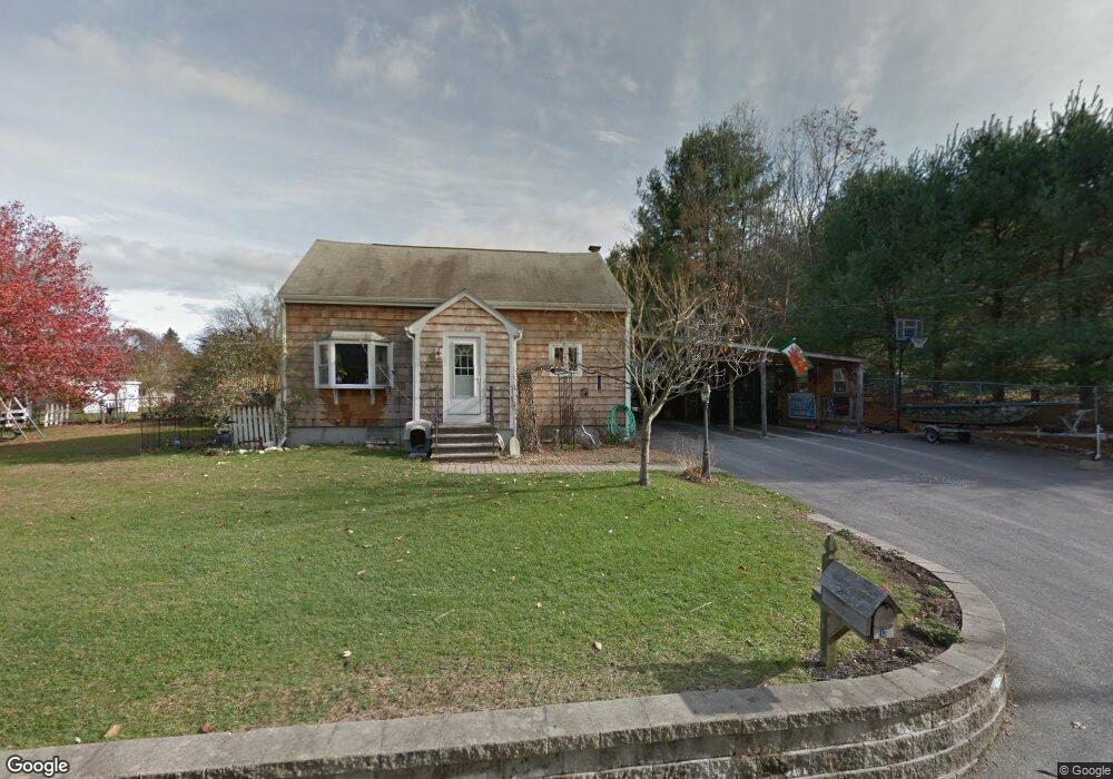
13 Staples Ln Blackstone, MA 01504
Estimated Value: $393,285 - $447,000
3
Beds
1
Bath
1,331
Sq Ft
$317/Sq Ft
Est. Value
About This Home
This home is located at 13 Staples Ln, Blackstone, MA 01504 and is currently estimated at $421,321, approximately $316 per square foot. 13 Staples Ln is a home located in Worcester County with nearby schools including Blackstone-Millville Regional High School, Founders Academy, and Beacon Charter School.
Ownership History
Date
Name
Owned For
Owner Type
Purchase Details
Closed on
Aug 22, 2005
Sold by
Erickson Errol R
Bought by
Tellier Nancy J and Tellier Peter J
Current Estimated Value
Home Financials for this Owner
Home Financials are based on the most recent Mortgage that was taken out on this home.
Original Mortgage
$241,650
Outstanding Balance
$126,942
Interest Rate
5.66%
Mortgage Type
Purchase Money Mortgage
Estimated Equity
$294,379
Create a Home Valuation Report for This Property
The Home Valuation Report is an in-depth analysis detailing your home's value as well as a comparison with similar homes in the area
Home Values in the Area
Average Home Value in this Area
Purchase History
| Date | Buyer | Sale Price | Title Company |
|---|---|---|---|
| Tellier Nancy J | $268,500 | -- |
Source: Public Records
Mortgage History
| Date | Status | Borrower | Loan Amount |
|---|---|---|---|
| Open | Tellier Nancy J | $241,650 |
Source: Public Records
Tax History Compared to Growth
Tax History
| Year | Tax Paid | Tax Assessment Tax Assessment Total Assessment is a certain percentage of the fair market value that is determined by local assessors to be the total taxable value of land and additions on the property. | Land | Improvement |
|---|---|---|---|---|
| 2025 | $4,609 | $305,200 | $136,100 | $169,100 |
| 2024 | $5,048 | $309,100 | $122,400 | $186,700 |
| 2023 | $4,924 | $304,300 | $122,400 | $181,900 |
| 2022 | $4,434 | $247,700 | $117,100 | $130,600 |
| 2021 | $3,967 | $211,900 | $106,500 | $105,400 |
| 2020 | $4,172 | $221,200 | $106,500 | $114,700 |
| 2019 | $4,304 | $227,600 | $108,800 | $118,800 |
| 2018 | $4,112 | $211,000 | $103,600 | $107,400 |
| 2017 | $3,779 | $196,200 | $103,600 | $92,600 |
| 2016 | $3,827 | $197,900 | $96,100 | $101,800 |
| 2015 | $3,820 | $196,100 | $96,100 | $100,000 |
Source: Public Records
Map
Nearby Homes
- 0 Main St
- 259 Main St
- 1 Tupperware Dr Unit 226
- 1 Tupperware Dr Unit 138
- 1 Tupperware Dr Unit 108
- 225-227 Main St
- 6 Old Mendon St
- 8 Old Mendon St Unit 8
- 122 Canal St
- 175 Saint Paul St
- 22 Colerick Ave
- 81 Fountain St
- 24 Reilly Ave
- 96 Main St Unit 1
- 470 Saint Paul St
- 12 Keough St
- 29 Graves Ave
- 4 Sharon Pkwy
- 15 Blackstone St
- 5 Lincoln Dr