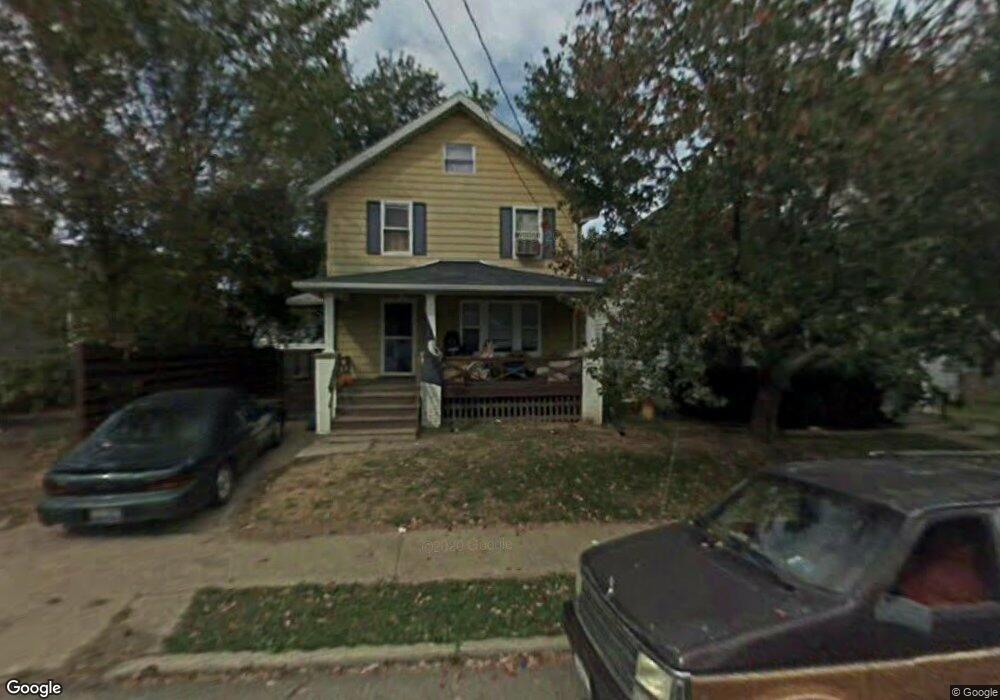
13 State St Mansfield, OH 44907
Estimated Value: $134,000
--
Bed
--
Bath
--
Sq Ft
1.01
Acres
About This Home
This home is located at 13 State St, Mansfield, OH 44907 and is currently priced at $134,000. 13 State St is a home located in Richland County with nearby schools including St. Peter's Elementary/Montessori School, St. Peter's High School/Junior High, and Discovery School.
Ownership History
Date
Name
Owned For
Owner Type
Purchase Details
Closed on
Aug 4, 2008
Sold by
Homesales Inc
Bought by
Bascom Eric and Bascom Shari
Current Estimated Value
Home Financials for this Owner
Home Financials are based on the most recent Mortgage that was taken out on this home.
Original Mortgage
$200,400
Interest Rate
6.41%
Mortgage Type
Purchase Money Mortgage
Purchase Details
Closed on
Jun 9, 2008
Sold by
Loretta Mark A
Bought by
Homesales Inc
Home Financials for this Owner
Home Financials are based on the most recent Mortgage that was taken out on this home.
Original Mortgage
$200,400
Interest Rate
6.41%
Mortgage Type
Purchase Money Mortgage
Purchase Details
Closed on
Apr 26, 2005
Sold by
Loretta Mark A
Bought by
Loretta Mark A and Loretta Terri L
Home Financials for this Owner
Home Financials are based on the most recent Mortgage that was taken out on this home.
Original Mortgage
$345,400
Interest Rate
8.73%
Mortgage Type
New Conventional
Create a Home Valuation Report for This Property
The Home Valuation Report is an in-depth analysis detailing your home's value as well as a comparison with similar homes in the area
Home Values in the Area
Average Home Value in this Area
Purchase History
| Date | Buyer | Sale Price | Title Company |
|---|---|---|---|
| Bascom Eric | $250,500 | Accutitle Agency Inc | |
| Homesales Inc | $150,000 | None Available | |
| Loretta Mark A | -- | Landsel Title Agency Inc |
Source: Public Records
Mortgage History
| Date | Status | Borrower | Loan Amount |
|---|---|---|---|
| Previous Owner | Bascom Eric | $200,400 | |
| Previous Owner | Loretta Mark A | $345,400 |
Source: Public Records
Tax History Compared to Growth
Tax History
| Year | Tax Paid | Tax Assessment Tax Assessment Total Assessment is a certain percentage of the fair market value that is determined by local assessors to be the total taxable value of land and additions on the property. | Land | Improvement |
|---|---|---|---|---|
| 2024 | $46 | $3,080 | $2,470 | $610 |
| 2023 | $46 | $3,080 | $2,470 | $610 |
| 2022 | $31 | $2,220 | $1,680 | $540 |
| 2021 | $31 | $2,220 | $1,680 | $540 |
| 2020 | $31 | $2,220 | $1,680 | $540 |
| 2019 | $45 | $1,950 | $1,410 | $540 |
| 2018 | $45 | $1,950 | $1,410 | $540 |
| 2017 | $49 | $1,950 | $1,410 | $540 |
| 2016 | $53 | $1,460 | $920 | $540 |
| 2015 | $53 | $1,460 | $920 | $540 |
| 2014 | $55 | $1,460 | $920 | $540 |
| 2012 | $17 | $1,460 | $920 | $540 |
Source: Public Records
Map
Nearby Homes
- 394 S Main St
- 94 Winding Way
- 147 Wolfe Ave
- 79 Greenwood Ave
- 139 Winwood Dr
- 223 Reform St
- 506 Harter Ave
- 506 Harter Ave Unit 508
- 172 -172 1 2 Lexington Ave
- 137 Lexington Ave
- 120 Grover St
- 0 Cline Ave Hedeen Abbeyfeale Unit 9066362
- 26 Florence Ave
- 286 S Main St
- 430 Beethoven St
- 490 Rembrandt St
- 505 Wood St
- 519 S Diamond St
- 205 S Diamond St
- 610 Woodville Rd