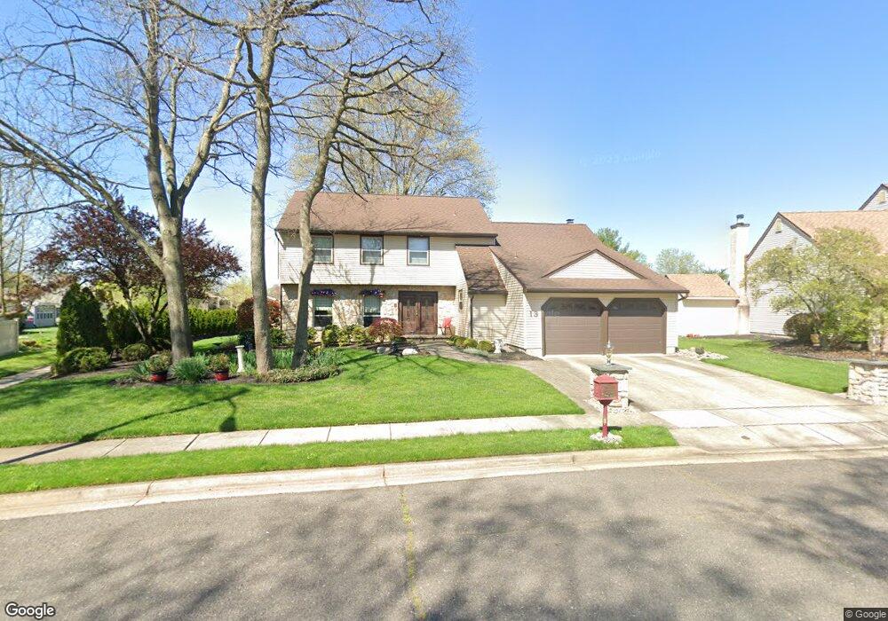
13 W Oleander Dr Mount Laurel, NJ 08054
Estimated Value: $495,570 - $565,000
--
Bed
--
Bath
2,708
Sq Ft
$198/Sq Ft
Est. Value
About This Home
This home is located at 13 W Oleander Dr, Mount Laurel, NJ 08054 and is currently estimated at $536,893, approximately $198 per square foot. 13 W Oleander Dr is a home located in Burlington County with nearby schools including Parkway Elementary School, T.E. Harrington Middle School, and Mount Laurel Hartford School.
Ownership History
Date
Name
Owned For
Owner Type
Purchase Details
Closed on
Mar 7, 2025
Sold by
Mclellan Robert B and Mclellan Monica M
Bought by
Robert And Monica Mclellan Trust and Mclellan
Current Estimated Value
Purchase Details
Closed on
Jul 9, 2008
Sold by
Israel Karen B and Israel Joseph L
Bought by
Israel Joseph L and Israel Karen B
Purchase Details
Closed on
Nov 15, 1988
Bought by
Mclellan Robert and Mclellan Monica
Create a Home Valuation Report for This Property
The Home Valuation Report is an in-depth analysis detailing your home's value as well as a comparison with similar homes in the area
Home Values in the Area
Average Home Value in this Area
Purchase History
| Date | Buyer | Sale Price | Title Company |
|---|---|---|---|
| Robert And Monica Mclellan Trust | -- | None Listed On Document | |
| Robert And Monica Mclellan Trust | -- | None Listed On Document | |
| Israel Joseph L | -- | None Available | |
| Mclellan Robert | $215,000 | -- |
Source: Public Records
Tax History Compared to Growth
Tax History
| Year | Tax Paid | Tax Assessment Tax Assessment Total Assessment is a certain percentage of the fair market value that is determined by local assessors to be the total taxable value of land and additions on the property. | Land | Improvement |
|---|---|---|---|---|
| 2025 | $8,669 | $274,600 | $78,500 | $196,100 |
| 2024 | $8,342 | $274,600 | $78,500 | $196,100 |
| 2023 | $8,342 | $274,600 | $78,500 | $196,100 |
| 2022 | $8,315 | $274,600 | $78,500 | $196,100 |
| 2021 | $8,158 | $274,600 | $78,500 | $196,100 |
| 2020 | $7,999 | $274,600 | $78,500 | $196,100 |
| 2019 | $7,917 | $274,600 | $78,500 | $196,100 |
| 2018 | $7,856 | $274,600 | $78,500 | $196,100 |
| 2017 | $7,653 | $274,600 | $78,500 | $196,100 |
| 2016 | $7,538 | $274,600 | $78,500 | $196,100 |
| 2015 | $7,450 | $274,600 | $78,500 | $196,100 |
| 2014 | $7,376 | $274,600 | $78,500 | $196,100 |
Source: Public Records
Map
Nearby Homes
- 70B Sumac Ct Unit 70B
- 74 Poppy Ct
- 60B Sumac Ct
- 23 E Oleander Dr
- 130B Birchfield Ct Unit 130B
- 123A Birchfield Ct Unit 123A
- 31 Quince Ct
- 13 Village Ct Unit 13
- 12 B E Daisy Ln
- 11 E Berwin Way
- 6 E Azalea Ln
- 124 W Berwin Way
- 5 Keswick Ct
- 10 Gretna Ct
- 907A Oliphant Ln Unit 907A
- 53 Saw Mill Dr
- 16 W Azalea Ln
- 1201A Ginger Ct
- 112B W Bluebell Ln Unit 112B
- 1 Adner Dr
- 12 W Oleander Dr
- 14 Oleander Ct
- 15 Oleander Ct
- 28 W Oleander Dr
- 11 W Oleander Dr
- 29 W Oleander Dr
- 7 Marigold Ct
- 16 Oleander Ct
- 6 Marigold Ct
- 27 W Oleander Dr
- 30 W Oleander Dr
- 38 W Peachtree Ct
- 10 W Oleander Dr
- 17 Oleander Ct
- 37 W Peachtree Ct
- 5 Marigold Ct
- 8 Marigold Ct
- 24 Oleander Ct
- 23 Oleander Ct
- 31 W Oleander Dr