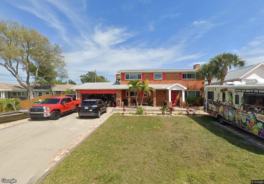
13 West Point Dr Cocoa Beach, FL 32931
Estimated Value: $858,000 - $1,483,000
3
Beds
2
Baths
2,269
Sq Ft
$494/Sq Ft
Est. Value
About This Home
This home is located at 13 West Point Dr, Cocoa Beach, FL 32931 and is currently estimated at $1,120,034, approximately $493 per square foot. 13 West Point Dr is a home located in Brevard County with nearby schools including Theodore Roosevelt Elementary School, Cocoa Beach Junior/Senior High School, and Cocoa Beach Christian School.
Ownership History
Date
Name
Owned For
Owner Type
Purchase Details
Closed on
Apr 1, 2015
Sold by
Krill John B and Krill Rose Mary
Bought by
Bunin Andrew S
Current Estimated Value
Home Financials for this Owner
Home Financials are based on the most recent Mortgage that was taken out on this home.
Original Mortgage
$376,000
Outstanding Balance
$290,814
Interest Rate
3.87%
Mortgage Type
New Conventional
Estimated Equity
$829,220
Purchase Details
Closed on
Jan 16, 2007
Sold by
Krill John B and Krill Rose Mary
Bought by
Krill John B and Krill Rose Mary
Purchase Details
Closed on
Jun 10, 1999
Sold by
Luetjen Ronald Dean and Luetjen Robin Michael
Bought by
Krill John B and Krill Rose Mary
Purchase Details
Closed on
Mar 29, 1999
Sold by
Luetjen H H
Bought by
Luetjen Ronald Dean and Luetjen Robin Michael
Create a Home Valuation Report for This Property
The Home Valuation Report is an in-depth analysis detailing your home's value as well as a comparison with similar homes in the area
Home Values in the Area
Average Home Value in this Area
Purchase History
| Date | Buyer | Sale Price | Title Company |
|---|---|---|---|
| Bunin Andrew S | $470,000 | International Title & Escrow | |
| Krill John B | -- | None Available | |
| Krill John B | $210,000 | -- | |
| Luetjen Ronald Dean | -- | -- |
Source: Public Records
Mortgage History
| Date | Status | Borrower | Loan Amount |
|---|---|---|---|
| Open | Bunin Andrew S | $376,000 |
Source: Public Records
Tax History
| Year | Tax Paid | Tax Assessment Tax Assessment Total Assessment is a certain percentage of the fair market value that is determined by local assessors to be the total taxable value of land and additions on the property. | Land | Improvement |
|---|---|---|---|---|
| 2025 | $10,205 | $823,470 | -- | -- |
| 2024 | $8,730 | $858,190 | -- | -- |
| 2023 | $8,730 | $697,360 | $430,000 | $267,360 |
| 2022 | $8,009 | $696,140 | $0 | $0 |
| 2021 | $7,345 | $547,510 | $370,000 | $177,510 |
| 2020 | $6,770 | $491,430 | $310,000 | $181,430 |
| 2019 | $7,072 | $504,270 | $310,000 | $194,270 |
| 2018 | $7,007 | $494,400 | $295,000 | $199,400 |
| 2017 | $6,429 | $423,090 | $280,000 | $143,090 |
| 2016 | $6,243 | $390,270 | $230,000 | $160,270 |
| 2015 | $5,420 | $322,280 | $200,000 | $122,280 |
| 2014 | $5,220 | $294,440 | $200,000 | $94,440 |
Source: Public Records
Map
Nearby Homes
- 1790 Bayshore Dr
- 1675 Bayshore Dr
- 1375 Bayshore Dr
- 2 River Falls Dr
- 1299 S Orlando Ave
- 1277 S Orlando Ave Unit 4B
- 2050 S Atlantic Ave
- 1527 S Atlantic Ave Unit 201
- 1563 S Atlantic Ave Unit 13
- 1305 S Atlantic Ave Unit 110
- 1515 S Atlantic Ave Unit 404
- 24 Olive St
- 1700 S Atlantic Ave Unit 104
- 1800 S Orlando Ave Unit 1
- 1139 S Brevard Ave
- 1155 S Atlantic Ave Unit 203
- 2001 Julep Dr Unit 206- 3rd Floor
- 7 Cove View Ct
- 1835 S Atlantic Ave Unit 301
- 1081 S Atlantic Ave
- 13 W Point Dr
- 12 W Point Dr
- 12 West Point Dr
- 14 W Point Dr
- 14 West Point Dr
- 11 W Point Dr
- 11 West Point Dr
- 23 West Point Dr
- 22 West Point Dr
- 23 W Point Dr
- 22 W Point Dr
- 24 West Point Dr
- 1800 Bayshore Dr
- 10 West Point Dr
- 15 West Point Dr
- 25 W Point Dr
- 1770 Bayshore Dr
- 21 West Point Dr
- 21 West Point Dr Unit 101
- 21 W Point Dr
Your Personal Tour Guide
Ask me questions while you tour the home.