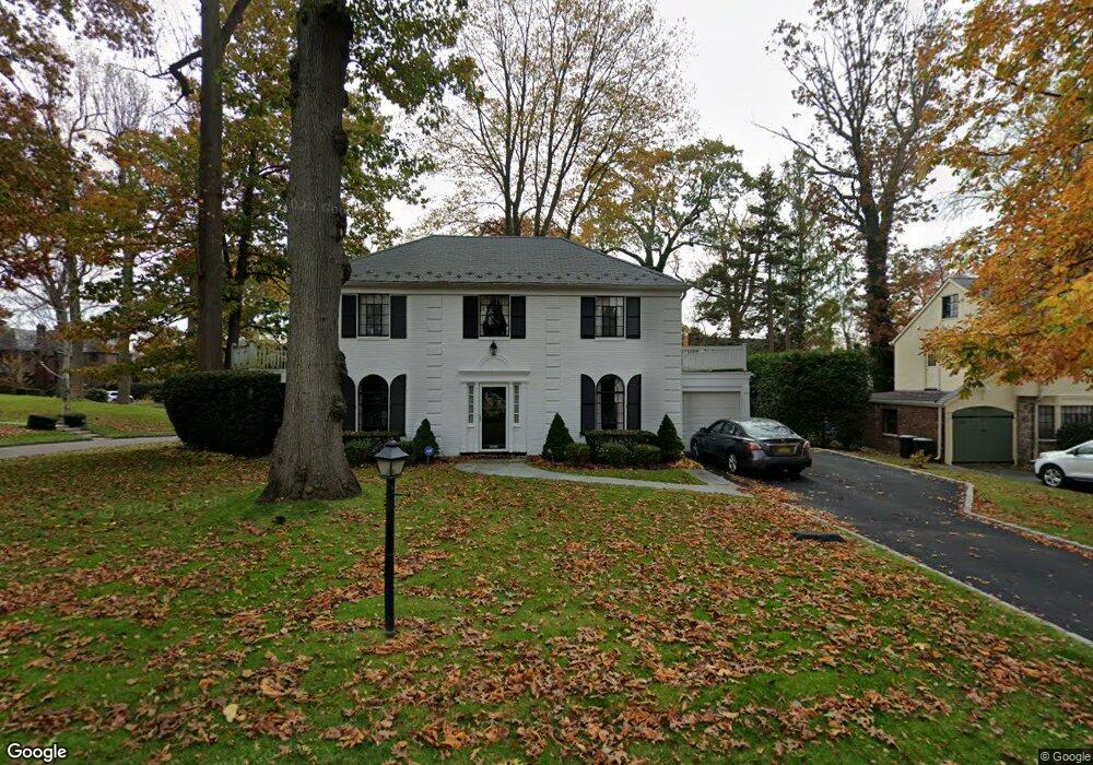
130 Andrew Rd Manhasset, NY 11030
Estimated Value: $1,725,884 - $2,030,000
--
Bed
3
Baths
2,007
Sq Ft
$936/Sq Ft
Est. Value
About This Home
This home is located at 130 Andrew Rd, Manhasset, NY 11030 and is currently estimated at $1,877,942, approximately $935 per square foot. 130 Andrew Rd is a home located in Nassau County with nearby schools including Manhasset Secondary School, St Mary's Elementary School, and Our Lady of Grace Montessori School.
Ownership History
Date
Name
Owned For
Owner Type
Purchase Details
Closed on
Jun 24, 2013
Sold by
Cobos Peter and Cobos Mary Ellen
Bought by
Cobos Maary Ellen
Current Estimated Value
Purchase Details
Closed on
Oct 13, 1995
Sold by
Boyd Helen
Bought by
Cobos Peter and Cobos Mary
Home Financials for this Owner
Home Financials are based on the most recent Mortgage that was taken out on this home.
Original Mortgage
$348,000
Interest Rate
7.6%
Create a Home Valuation Report for This Property
The Home Valuation Report is an in-depth analysis detailing your home's value as well as a comparison with similar homes in the area
Home Values in the Area
Average Home Value in this Area
Purchase History
| Date | Buyer | Sale Price | Title Company |
|---|---|---|---|
| Cobos Maary Ellen | -- | -- | |
| Cobos Peter | $435,000 | -- |
Source: Public Records
Mortgage History
| Date | Status | Borrower | Loan Amount |
|---|---|---|---|
| Previous Owner | Cobos Peter | $348,000 |
Source: Public Records
Tax History Compared to Growth
Tax History
| Year | Tax Paid | Tax Assessment Tax Assessment Total Assessment is a certain percentage of the fair market value that is determined by local assessors to be the total taxable value of land and additions on the property. | Land | Improvement |
|---|---|---|---|---|
| 2025 | $18,121 | $1,134 | $579 | $555 |
| 2024 | $5,711 | $1,094 | $558 | $536 |
| 2023 | $19,283 | $1,247 | $731 | $516 |
| 2022 | $19,283 | $1,158 | $601 | $557 |
| 2021 | $17,922 | $1,259 | $653 | $606 |
| 2020 | $20,285 | $1,983 | $1,827 | $156 |
| 2019 | $19,642 | $1,983 | $1,827 | $156 |
| 2018 | $18,615 | $1,983 | $0 | $0 |
| 2017 | $10,848 | $1,983 | $1,827 | $156 |
| 2016 | $17,113 | $1,983 | $1,827 | $156 |
| 2015 | $5,975 | $1,983 | $1,827 | $156 |
| 2014 | $5,975 | $1,983 | $1,827 | $156 |
| 2013 | $5,684 | $1,983 | $1,827 | $156 |
Source: Public Records
Map
Nearby Homes
- 44 Old ox Rd
- 60 Thayer Rd
- 50 Eakins Rd
- 305 Nassau Ave
- 414 Hunt Ln
- 53 Stuart Place
- 65 Old Mill Rd
- 39 Hawthorne Place
- 90 Gaynor Ave
- 15 Gaynor Ave Unit 2H
- 80 Clapham Ave
- 17 Pinewood Rd
- 20 Mill Spring Rd
- 17 Highland Terrace
- 4 Kimson Ct
- 207 Mill Spring Rd
- 183 Mill Spring Rd
- 112 Chapel Rd
- 42 Mora Ct
- 191 Elderfields Rd
- 124 Andrew Rd
- 41 Rockywood Rd
- 89 Woodcut Ln
- 70 Woodcut Ln
- 127 Andrew Rd
- 33 Rockywood Rd
- 118 Andrew Rd
- 80 Woodcut Ln
- 121 Andrew Rd
- 27 Rockywood Rd
- 90 Woodcut Ln
- 112 Andrew Rd
- 59 Rockywood Rd
- 115 Andrew Rd
- 44 Rockywood Rd
- 126 Ridge Crescent
- 132 Ridge Crescent
- 34 Rockywood Rd
- 21 Rockywood Rd
- 120 Ridge Crescent