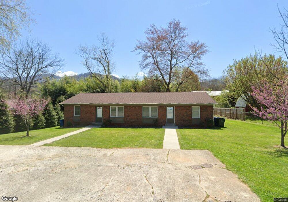
130 Broad St Waynesville, NC 28786
Estimated Value: $399,000 - $422,000
4
Beds
2
Baths
1,740
Sq Ft
$236/Sq Ft
Est. Value
About This Home
This home is located at 130 Broad St, Waynesville, NC 28786 and is currently estimated at $411,000, approximately $236 per square foot. 130 Broad St is a home located in Haywood County with nearby schools including Hazelwood Elementary, Waynesville Middle, and Tuscola High.
Ownership History
Date
Name
Owned For
Owner Type
Purchase Details
Closed on
Sep 4, 2025
Sold by
Rich Jackie G and Bowers Jackie G
Bought by
Bowers Jackie G and Bowers Charles T
Current Estimated Value
Home Financials for this Owner
Home Financials are based on the most recent Mortgage that was taken out on this home.
Original Mortgage
$100,000
Outstanding Balance
$100,000
Interest Rate
6.63%
Mortgage Type
Credit Line Revolving
Estimated Equity
$311,000
Purchase Details
Closed on
Sep 13, 2017
Sold by
Rich Michael W
Bought by
Rich Jackie G
Purchase Details
Closed on
Jan 11, 1999
Bought by
Rich Michael W and Rich Jackie G
Create a Home Valuation Report for This Property
The Home Valuation Report is an in-depth analysis detailing your home's value as well as a comparison with similar homes in the area
Home Values in the Area
Average Home Value in this Area
Purchase History
| Date | Buyer | Sale Price | Title Company |
|---|---|---|---|
| Bowers Jackie G | -- | Servicelink | |
| Rich Jackie G | -- | None Available | |
| Rich Michael W | $83,900 | -- |
Source: Public Records
Mortgage History
| Date | Status | Borrower | Loan Amount |
|---|---|---|---|
| Open | Bowers Jackie G | $100,000 |
Source: Public Records
Tax History Compared to Growth
Tax History
| Year | Tax Paid | Tax Assessment Tax Assessment Total Assessment is a certain percentage of the fair market value that is determined by local assessors to be the total taxable value of land and additions on the property. | Land | Improvement |
|---|---|---|---|---|
| 2025 | -- | $194,300 | $40,600 | $153,700 |
| 2024 | $1,387 | $194,300 | $40,600 | $153,700 |
| 2023 | $1,387 | $194,300 | $40,600 | $153,700 |
| 2022 | $1,358 | $194,300 | $40,600 | $153,700 |
| 2021 | $1,358 | $194,300 | $40,600 | $153,700 |
| 2020 | $1,146 | $141,500 | $40,600 | $100,900 |
| 2019 | $1,156 | $141,500 | $40,600 | $100,900 |
| 2018 | $1,156 | $141,500 | $40,600 | $100,900 |
| 2017 | $1,156 | $141,500 | $0 | $0 |
| 2016 | $1,145 | $144,400 | $0 | $0 |
| 2015 | $1,145 | $144,400 | $0 | $0 |
| 2014 | $966 | $144,400 | $0 | $0 |
Source: Public Records
Map
Nearby Homes
- 204 Oakdale Rd
- 154 Lowell St
- 158 Morning Dr
- 71 Auburn Park Dr
- 508 Pigeon St
- 30 Babb St
- 161 S Hill St
- 149 Short St
- 84 S Hill St
- 684 Woodfield Dr
- 152 Springview Dr
- 671 S Haywood St Unit 108B
- 111 Digging Seng Trail
- 111 Digging Seng Trail Unit 138
- 169 East St
- 622 S Haywood St Unit 207
- 147 Preservation Way
- 156 Burma Rd
- 9999 Cavalier Dr
- TBD Adams St Unit 1