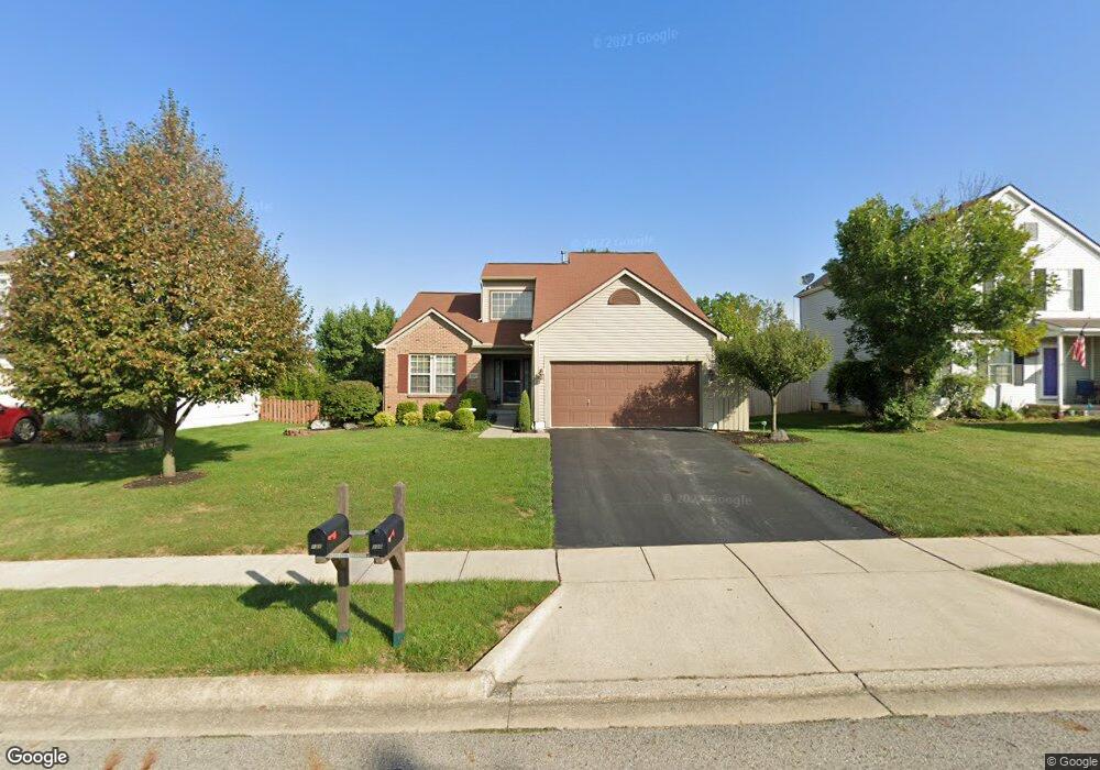
130 Brooksedge Dr Pataskala, OH 43062
Estimated Value: $339,136 - $370,000
3
Beds
3
Baths
1,660
Sq Ft
$215/Sq Ft
Est. Value
About This Home
This home is located at 130 Brooksedge Dr, Pataskala, OH 43062 and is currently estimated at $357,034, approximately $215 per square foot. 130 Brooksedge Dr is a home located in Licking County with nearby schools including Licking Heights High School and Grace Christian School.
Ownership History
Date
Name
Owned For
Owner Type
Purchase Details
Closed on
Feb 24, 2022
Sold by
Woodling Jr Robert J and Woodling Glenda H
Bought by
Adams Kendra
Current Estimated Value
Purchase Details
Closed on
Apr 2, 1997
Sold by
2728 Holding Corp
Bought by
Robert J and Glenda
Home Financials for this Owner
Home Financials are based on the most recent Mortgage that was taken out on this home.
Original Mortgage
$126,687
Interest Rate
7.65%
Mortgage Type
FHA
Create a Home Valuation Report for This Property
The Home Valuation Report is an in-depth analysis detailing your home's value as well as a comparison with similar homes in the area
Home Values in the Area
Average Home Value in this Area
Purchase History
| Date | Buyer | Sale Price | Title Company |
|---|---|---|---|
| Adams Kendra | -- | Holfinger Stevenson Law Firm | |
| Robert J | $132,000 | -- |
Source: Public Records
Mortgage History
| Date | Status | Borrower | Loan Amount |
|---|---|---|---|
| Previous Owner | Robert J | $126,687 |
Source: Public Records
Tax History
| Year | Tax Paid | Tax Assessment Tax Assessment Total Assessment is a certain percentage of the fair market value that is determined by local assessors to be the total taxable value of land and additions on the property. | Land | Improvement |
|---|---|---|---|---|
| 2024 | $5,473 | $104,650 | $22,750 | $81,900 |
| 2023 | $5,672 | $104,650 | $22,750 | $81,900 |
| 2022 | $4,400 | $71,410 | $15,930 | $55,480 |
| 2021 | $4,485 | $71,410 | $15,930 | $55,480 |
| 2020 | $4,433 | $71,410 | $15,930 | $55,480 |
| 2019 | $3,988 | $59,610 | $11,380 | $48,230 |
| 2018 | $4,029 | $0 | $0 | $0 |
| 2017 | $4,123 | $0 | $0 | $0 |
| 2016 | $3,072 | $0 | $0 | $0 |
| 2015 | $2,929 | $0 | $0 | $0 |
| 2014 | $3,842 | $0 | $0 | $0 |
| 2013 | $3,090 | $0 | $0 | $0 |
Source: Public Records
Map
Nearby Homes
- 5284 Taylor Rd SW
- 771 Lilly Landing Ln
- 8176 Kennedy Rd
- 8674 Aconite Dr Unit 460
- 8722 Conestoga Valley Dr
- 8640 Melton Fields Dr
- 1219 Bohannon St
- 8648 Crooked Maple Dr
- 8661 Crooked Maple Dr
- 8565 Haleigh Woods Dr
- 725 Flowering Cherry Ct
- 748 Loreto Ln
- 670 Redwood Valley Dr
- 7913 Birch Creek Dr
- 242 Monarch Dr
- 7894 Champaign Dr
- 8340 Crete Ln
- 8442 Arlen Dr
- 392 Old Ivory Ct
- 7800 Birch Creek Dr
- 126 Brooksedge Dr
- 132 Brooksedge Dr
- 136 Brooksedge Dr
- 120 Brooksedge Dr
- 416 Lockmead Dr
- 412 Lockmead Dr
- 420 Lockmead Dr
- 408 Lockmead Dr
- 131 Brooksedge Dr
- 140 Brooksedge Dr
- 424 Lockmead Dr
- 125 Brooksedge Dr
- 116 Brooksedge Dr
- 119 Brooksedge Dr
- 404 Lockmead Dr
- 428 Lockmead Dr
- 302 Stonemast Loop
- 146 Brooksedge Dr
- 112 Brooksedge Dr
- 294 Stonemast Loop
Your Personal Tour Guide
Ask me questions while you tour the home.