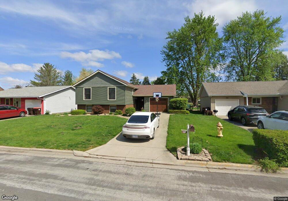
130 Heritage Ave Lincoln, IL 62656
Estimated Value: $145,633 - $230,000
4
Beds
--
Bath
840
Sq Ft
$213/Sq Ft
Est. Value
About This Home
This home is located at 130 Heritage Ave, Lincoln, IL 62656 and is currently estimated at $179,158, approximately $213 per square foot. 130 Heritage Ave is a home located in Logan County with nearby schools including Chester-East Lincoln Elementary School, Lincoln Community High School, and Carroll Catholic School.
Ownership History
Date
Name
Owned For
Owner Type
Purchase Details
Closed on
Aug 25, 2010
Sold by
Irwin Thomas M and Irwin Laura M
Bought by
Kavelman Trent J and Kavelman Lindsey A
Current Estimated Value
Home Financials for this Owner
Home Financials are based on the most recent Mortgage that was taken out on this home.
Original Mortgage
$125,492
Outstanding Balance
$83,286
Interest Rate
4.54%
Mortgage Type
Stand Alone First
Estimated Equity
$95,872
Create a Home Valuation Report for This Property
The Home Valuation Report is an in-depth analysis detailing your home's value as well as a comparison with similar homes in the area
Home Values in the Area
Average Home Value in this Area
Purchase History
| Date | Buyer | Sale Price | Title Company |
|---|---|---|---|
| Kavelman Trent J | -- | -- |
Source: Public Records
Mortgage History
| Date | Status | Borrower | Loan Amount |
|---|---|---|---|
| Open | Kavelman Trent J | $125,492 |
Source: Public Records
Tax History Compared to Growth
Tax History
| Year | Tax Paid | Tax Assessment Tax Assessment Total Assessment is a certain percentage of the fair market value that is determined by local assessors to be the total taxable value of land and additions on the property. | Land | Improvement |
|---|---|---|---|---|
| 2024 | $3,413 | $45,840 | $7,610 | $38,230 |
| 2023 | $3,182 | $42,450 | $7,050 | $35,400 |
| 2022 | $3,022 | $39,670 | $6,590 | $33,080 |
| 2021 | $2,902 | $38,090 | $6,330 | $31,760 |
| 2020 | $2,868 | $37,530 | $6,240 | $31,290 |
| 2019 | $2,803 | $36,800 | $6,120 | $30,680 |
| 2018 | $2,770 | $36,080 | $6,000 | $30,080 |
| 2017 | $2,775 | $36,080 | $6,000 | $30,080 |
| 2016 | $2,756 | $36,040 | $5,990 | $30,050 |
| 2015 | $2,923 | $38,960 | $5,790 | $33,170 |
| 2014 | $2,923 | $38,960 | $5,790 | $33,170 |
| 2013 | $2,923 | $36,990 | $5,500 | $31,490 |
| 2012 | $2,923 | $37,660 | $5,600 | $32,060 |
Source: Public Records
Map
Nearby Homes
- 2294 Railsplitter Ave
- 1354 Airport Rd
- 2354 Railsplitter Ave
- 103 Crestwood Dr
- 102 Crestwood Dr
- 145 Half Moon St
- 180 Regent St
- 1503 N Kankakee St
- 1431 N Ottawa St
- 1208 N Kankakee St
- 1204 N Ottawa St
- 1019 N Mclean St
- 1107 N Kankakee St
- 311 Davenport St
- 1842 Castle Pine Place
- 6 Meadow Ln
- 915 Peoria St
- 1624 Delavan St
- 620 Tremont St
- 315 N Sherman St
- 140 Heritage Ave
- 120 Heritage Ave
- 150 Heritage Ave
- 135 Heritage Ave
- 145 Heritage Ave
- 110 Heritage Ave
- 125 Heritage Ave
- 155 Heritage Ave
- 160 Heritage Ave
- 115 Heritage Ave
- 105 Heritage Ave
- 170 Heritage Ave
- 2295 Railsplitter Ave
- 165 Heritage Ave
- 180 Heritage Ave
- 185 Heritage Ave
- 1360 Airport Rd
- 1362 Airport Rd
- 2305 Railsplitter Ave
- 200 Heritage Ave