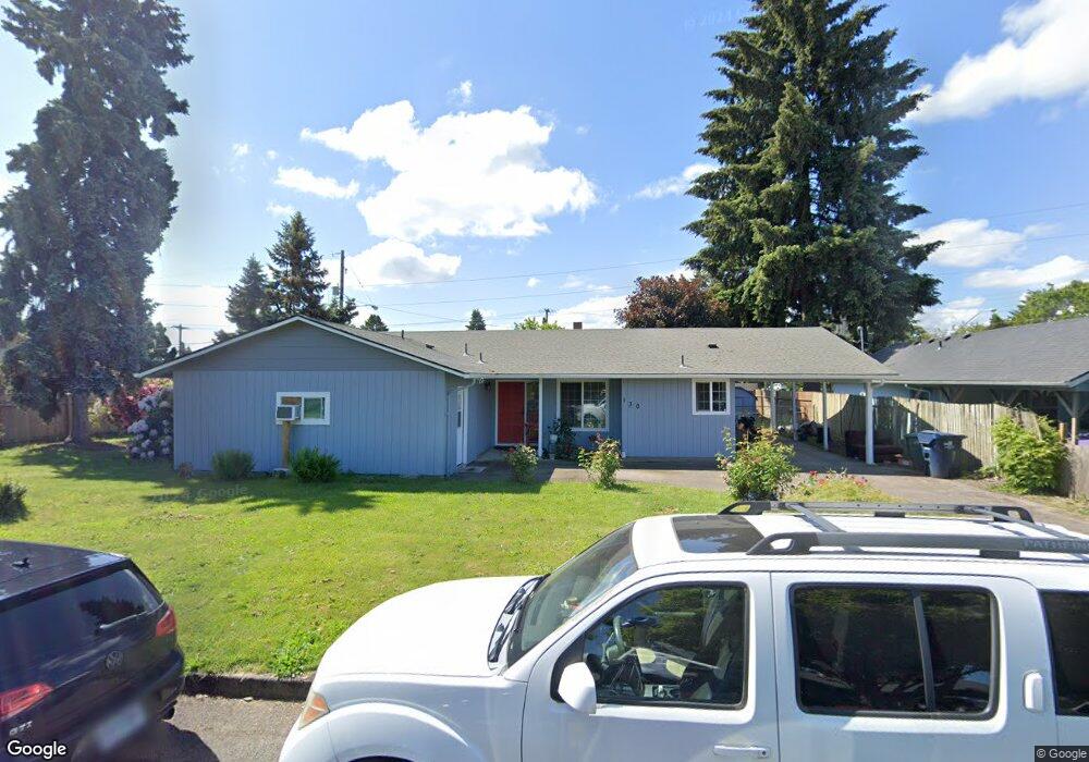
130 Hoyt Ave Eugene, OR 97404
Santa Clara NeighborhoodEstimated Value: $381,114 - $434,000
3
Beds
2
Baths
1,274
Sq Ft
$322/Sq Ft
Est. Value
About This Home
This home is located at 130 Hoyt Ave, Eugene, OR 97404 and is currently estimated at $410,279, approximately $322 per square foot. 130 Hoyt Ave is a home located in Lane County with nearby schools including Spring Creek Elementary School, Madison Middle School, and North Eugene High School.
Ownership History
Date
Name
Owned For
Owner Type
Purchase Details
Closed on
Mar 12, 2003
Sold by
Gilbert Michael A and Gilbert Darlene P
Bought by
Silva Anastacio Dario and Figueroa Virginia
Current Estimated Value
Home Financials for this Owner
Home Financials are based on the most recent Mortgage that was taken out on this home.
Original Mortgage
$130,100
Outstanding Balance
$54,733
Interest Rate
5.83%
Estimated Equity
$355,546
Purchase Details
Closed on
Jan 24, 2001
Sold by
Gilbert Michael A
Bought by
Gilbert Michael A and Gilbert Darlene P
Home Financials for this Owner
Home Financials are based on the most recent Mortgage that was taken out on this home.
Original Mortgage
$108,000
Interest Rate
7.41%
Create a Home Valuation Report for This Property
The Home Valuation Report is an in-depth analysis detailing your home's value as well as a comparison with similar homes in the area
Home Values in the Area
Average Home Value in this Area
Purchase History
| Date | Buyer | Sale Price | Title Company |
|---|---|---|---|
| Silva Anastacio Dario | $130,100 | Fidelity Natl Title Co Of Or | |
| Gilbert Michael A | -- | Western Pioneer Title Co |
Source: Public Records
Mortgage History
| Date | Status | Borrower | Loan Amount |
|---|---|---|---|
| Open | Silva Anastacio Dario | $130,100 | |
| Previous Owner | Gilbert Michael A | $108,000 |
Source: Public Records
Tax History
| Year | Tax Paid | Tax Assessment Tax Assessment Total Assessment is a certain percentage of the fair market value that is determined by local assessors to be the total taxable value of land and additions on the property. | Land | Improvement |
|---|---|---|---|---|
| 2025 | $2,664 | $208,154 | -- | -- |
| 2024 | $2,650 | $202,092 | -- | -- |
| 2023 | $2,650 | $196,206 | $0 | $0 |
| 2022 | $2,491 | $190,492 | $0 | $0 |
| 2021 | $2,286 | $184,944 | $0 | $0 |
| 2020 | $2,328 | $179,558 | $0 | $0 |
| 2019 | $2,242 | $174,329 | $0 | $0 |
| 2018 | $2,038 | $164,322 | $0 | $0 |
| 2017 | $1,883 | $164,322 | $0 | $0 |
| 2016 | $1,753 | $159,536 | $0 | $0 |
| 2015 | $1,678 | $154,889 | $0 | $0 |
| 2014 | $1,569 | $150,378 | $0 | $0 |
Source: Public Records
Map
Nearby Homes
- 124 E Anchor Ave
- 355 River Loop 2
- 3648 Rivercrest Dr
- 158 Mackin Ave
- 229 Mackin Ave
- 3724 Alladin Way
- 3755 Kendra St
- 349 Greenfield Ave
- 514 Warrington Ave
- 47 van Fossen Ct
- 4060 Hampshire Ln
- 161 Lynnbrook Dr
- 190 River Loop 1
- 3007 River Rd
- 2989 Dahlia Ln
- 4366 Berry Ln
- 4385 Berry Ln
- 240 Dibblee Ln
- 4351 Katy Ln
- 110 Calumet Ave
Your Personal Tour Guide
Ask me questions while you tour the home.